
Vietnam collaborates with Thales Alenia Space on SAR solution
April 3, 2023
Thales Alenia Space, along with Viettel and MKE, have been selected by Vinamarine to provide Vietnam with a MEOLUT Next ground station.
Read More
Thales Alenia Space, along with Viettel and MKE, have been selected by Vinamarine to provide Vietnam with a MEOLUT Next ground station.

The catastrophic earthquake that struck Turkiye and northern Syria on Feb. 6, killing more than 50,000 people, has highlighted the need for improved methods to monitor surface changes.
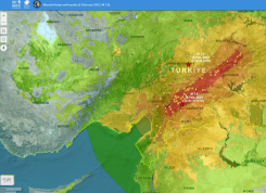
UNOSAT announced via Twitter that it had activated emergency mapping services of Turkey and northern Syria after the magnitude 7.8 earthquake hit.
The U.S. Department of Transportation’s Federal Aviation Administration (FAA) has awarded $2.7 million to support research on how […]
![Image: NAPSG [https://www.napsgfoundation.org/]](https://www.gpsworld.com/wp-content/uploads/2020/11/NAPSG-webpage-2.jpg)
Tenacity of spirit is one of the great virtues. Supporters of geospatial technology have often had to endure […]
Communities in need of resources can access location intelligence technology at no cost with six-month trial Location intelligence […]

Jeremy Kirkendall, senior GIS administrator for the NASA Disasters Program, gives GPS World an overview of the program […]
High-resolution airborne lidar data to be acquired over 34,000 square miles for disaster response and recovery. Under an […]


Follow Us