February 17, 2026 New Emesent GX1 is all-in-one SLAM lidar, RTK and 360° imagery scanner By Tracy Cozzens
December 4, 2025 Voyant Photonics expands Carbon lidar platform with chip-scale sensing By Tracy Cozzens
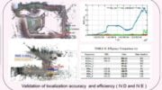
November 24, 2025 New data collection and mobile mapping software used in surveying and mapping projects By Jesse Khalil
December 16, 2024 Launchpad: New surveying and mapping products, MEMS sensors and more By Jesse Khalil