
Launchpad: Rescue beacon, satellite imagery, z-axis positioning
November 10, 2022
A roundup of recent products in the GNSS and inertial positioning industry from the November 2022 issue of GPS World magazine.
Read More
A roundup of recent products in the GNSS and inertial positioning industry from the November 2022 issue of GPS World magazine.
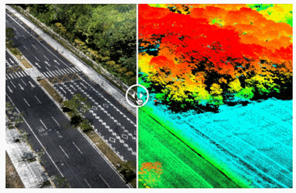
Cepton Inc. is working with LidarSwiss Solutions GmbH to deploy its lidar technology in a drone-based mapping and […]

The Earth Archive Initiative is an unprecedented scientific effort to create a digital twin of the entire surface […]

Avalanches can be a danger for skiers as well as for the resort towns that welcome them. For […]
SLAM-based mobile mapping with integrated 360° color is a rugged, geo-enabled, high-density and versatile workhorse Kaarta, an innovator […]

Streaming 3D geospatial technology company Cesium will support the Smithsonian Institution by streaming 3D models of massive objects in […]

DT Research has designed a new rugged tablet with 3D imaging that is purpose-built for 3D mapping with […]
Topcon Positioning Group introduced Topcon ContextCapture, powered by Bentley Systems, a reality modeling software solution that will be […]


Follow Us