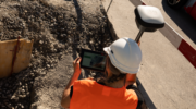
July 13, 2026 High-precision GNSS moves into the mainstream: What wider access to precision positioning means for geospatial workflows By Jose Aponte
October 14, 2025 NV5 to deploy Hexagon’s Leica CoastalMapper bathymetric lidar system By Jesse Khalil
March 20, 2025 Launchpad: Surveying and mapping solutions, latest OEM innovations and more By Jesse Khalil
December 16, 2024 Launchpad: New surveying and mapping products, MEMS sensors and more By Jesse Khalil
December 4, 2024 Notre Dame Cathedral reopens: 3D mapping guides historic restoration By Jesse Khalil
September 19, 2024 Leica Geosystems unveils AI-powered solution for construction layout By Jesse Khalil
June 17, 2024 Launchpad: Upgraded surveying software, application suite, GPS integrity module By Jesse Khalil