Listen to this content
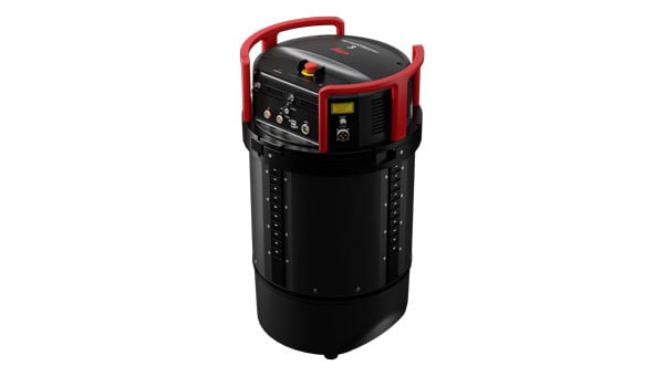
Leica Geosystems, part of Hexagon, has introduced the Leica TerrainMapper-3 airborne lidar sensor. It features new scan pattern reconfigurability to support a variety of applications and requirements in a single system.
The system offers three scan patterns, which allow users to customize the sensor’s performance to fit specific applications. Its circle scan patterns are designed to improve 3D modeling of urban areas or steep terrains. The ellipse scan patterns use data capture for more traditional mapping applications. Skew ellipse scan patterns are aimed at improving point density for infrastructures and corridor mapping applications.
The sensor has a high scan speed rate and a 60° adjustable field of view to maximize data collection with fewer flight lines. The TerrainMapper-3 is complemented by the Leica MFC150 4-band camera, which operates with the same 60° field of view coverage as the lidar for exact data consistency.
The device’s reduced beam divergence offers more accurate results, while its new multiple pulses in air (MPiA) handling is designed to deliver more consistent data acquisition, even in steep terrain.
The new system introduces possibilities for real-time full waveform recording at maximum pulse rate to open opportunities for advanced and automated point classification.


