Listen to this content

This is an introduction to the February 2024 Innovation article, “GNSS Timing Measurements from a Low-Earth Orbiting Satellite.”
In 1999, professors Jordi Puig-Suari at California Polytechnic State University and Bob Twiggs at Stanford University proposed a design for a miniaturized satellite that would allow students to more easily develop the skills necessary for the design, construction, testing and operation of satellites in low-Earth orbit (LEO). These nanosatellites would be built using standardized modules with a useful volume of 10 × 10 × 10 centimeters (hence the designation cube satellite or CubeSat) with a maximum mass of 2 kilograms. Apparently, the inspiration for the design came from the plastic box used to display “Beanie Babies,” a line of small stuffed toys. While a CubeSat can be constructed using one module or unit, termed a 1U design, modules can be stacked together to form sizes of 2U, 3U and so on.
Initially just a suggested form factor, the design was widely adopted by nanosatellite developers and in 2017 the International Organization for Standardization published the ISO 17770:2017 standard to formally define the physical, mechanical, electrical and operational requirements of CubeSats.
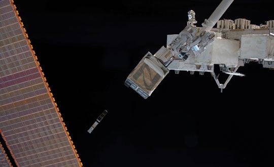
While some CubeSats have been launched as secondary payloads on launch vehicles, many have been released into space having been first launched to the International Space Station (ISS) in a cargo resupply vehicle. For example, Nanoracks developed a CubeSat deployer that can house multiple CubeSats. Once on the ISS, the deployer is positioned so that when its forward-facing door is opened, a spring at the back of the deployer pushes the CubeSats into space.
As of January 1, 2024, 2,323 CubeSats have been launched according to a nanosatellite database. Some of these satellites demonstrated new space technologies while others were science investigation missions to study Earth’s atmosphere or space weather or astronomical objects or other satellites. Many of these CubeSats, if not most, have been built by universities from around the world. In fact, various space agencies have programs to support the development and launch of CubeSats by students, such as NASA’s CubeSat Launch Initiative and the Canadian Space Agency’s Canadian CubeSat Project (CCP). As most CubeSats go into LEO, a lot of them have already deorbited. However, while in space, they provided a wealth of data of various kinds and many of the accumulated datasets are still being mined for new results. A nice example of such a dataset is that provided by Bobcat-1, a 3U CubeSat developed by Ohio University. Its mission, in addition to training students in aerospace technologies, was primarily to assess the feasibility of monitoring the time offsets between different GNSS, but also GNSS spectrum monitoring and testing a software-defined GNSS receiver. In this quarter’s “Innovation” column, authors from the Bobcat-1 team discuss some of their work on Galileo-to-GPS system time offsets. Go Bobcats!


