No audio available for this content.
Just a couple of pieces of drone news this month — who would imagine flying a fixed-wing drone into the plume of a volcano? And some new advances in tethered drone capability.
Global warming/climate change — a collection of words which can sometimes lead to disputes, disagreements and dismay. These words can fill people with enthusiasm for change and in others have them just shaking heads. I saw a video some time ago made by an eminent scientist who claimed that all the efforts made by humans to pollute over the centuries and the efforts being made now to help the atmosphere, were insignificant when all the junk kicked out on a daily basis by volcanoes around the world was taken into account.
Nevertheless, it’s for sure that the climate is changing — by human hand or by nature — some people are still seeking a scientific basis to establish if it can somehow be remedied — a greener approach which could stop or limit our ability to go on polluting the only world we have, or at least some version of curbing what we are doing to make things worse.
So it was exciting for me to see recent reports of an expedition from last year in Papua New Guinea where an international group used drones in an attempt to measure carbon dioxide, sulfur dioxide and hydrogen sulfide coming out of the active Manam volcano. The objective appeared to be direct sampling of the volcano plume to determine content, not just for measurement alone but perhaps also eventually maybe monitoring changes in gas content to forecast future eruptions.
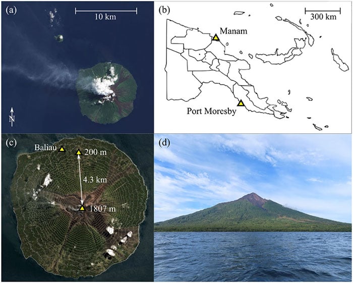
A series of significant eruptions last took place 2004-2006, and again in 2014, but since then Manam has continued to be explosively active all the way up to the present day. It’s possible to climb almost 6,000 feet to the upper dome, but for more efficient regular monitoring the expedition wanted to demonstrate that a fixed wing drone, operated from a village 2.7 miles away, almost at sea level, would work better. Satellite data on emissions is also available, but apparently no predictions of CO2 content has so far been possible, so land based survey and direct sampling might greatly improve understanding.
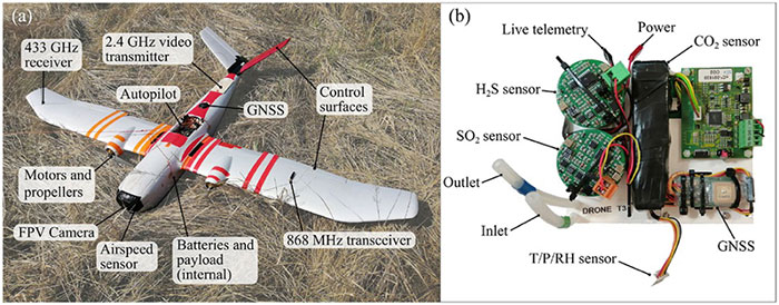
Hand launched, with an internal parachute system for recovery, the Titan UAV, which can lift a payload of around 2 pounds to an altitude of 7,500 feet and has a range of more than six miles. For the trip to the volcano, two 4k cameras provided forward and rear views, oversized electric motors were installed to provide more thrust and onboard data capture allowed for subsequent analysis of the vehicle dynamics as well as the gas content of the environment. Live data was also transmitted real-time to the operator and monitoring crew and was also stored for later review. The autopilot on the drone is capable of automatic GPS waypoint navigation and manual flight mode may be engaged by the operator. The drone carries GNSS, barometric altitude, airspeed indication and IMU sensors.
The automatically flown flight path up 5,300 feet to one of the two volcanic outlets on the mountain followed a zig-zag path to a point offset from the smoking caldera, and if the drone failed to then turn and intercept the plume automatically, it was manually maneuvered in level flight into the smoke column. Plume intercept was interpreted as a steep increase in sulphur dioxide concentration, and at the same time there were increases forces on the drone, at times up to 2.5 g, with roll deviations up to 25 degrees and significant uplift. Not unsurprising rock and roll given the energy being released by the volcano.
After each plume intercept the drone then left the area and descended in a spiral to the launch site, being recovered by manual parachute release. Two flights were successful, yielding lots of data for analysis, but there was an upset while in the plume on the third flight and the vehicle was lost, thought to be related to pulsating increases in the velocity of gas released by magma in the crater and what looked like a 7-g increase in forces on the vehicle. The plume was figured to be between 1800 ft and 2,500 feet wide, using the length of time spent in the smoke column and the speed being flown.
The flights were all conducted under Beyond Visual Line of Sight (BVLOS) conditions as agreed by the local air control agency and significant drone design improvements and flight techniques for subsequent ‘volcano operations’ were recommended. Gas emissions were measured at 3,450 to 4,360 tons/day CO2 and 4,840 to 5,880 tons/day SO2 — so lots of carbon pollution from one of the earth’s most active volcanos, one of around 500 worldwide.
Accreditations: Copyright © 2020 Wood K, et. al. BVLOS UAS Operations in Highly-Turbulent Volcanic Plumes. Frontiers in Robotics and AI. doi: https://doi.org/10.3389/frobt.2020.549716
Tethered drones offer advantages for some specific applications such as longer flight times for surveillance. Recent outings by Elistair tethered drone systems have included crowd monitoring and TV coverage for Super Bowl in Atlanta, Ryder Cup golf near Paris France, traffic monitoring in Lyon France, TV coverage for the Alpine World Ski Championships in Sweden, Paris Le Bourget airport approach light monitoring, Trinidad carnival crowd monitoring, Kentucky festival crowd monitoring and communications relay, fire control exercises in Greece, New Year’s crowd monitoring in Vienna and crowd monitoring at Madrid’s soccer stadium.
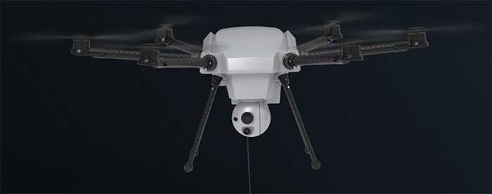
But endurance is a key element for longer term surveillance, so Elistair has come out with Orion 2 which has extended the previous 8-12 hours operations envelop all the way out to 24 hours — and added IP54 dust and water rating, so weather shouldn’t interrupt service.
The tether now extends up to 330 feet so the drone can see out further and it can now also lift a 4.5-pound payload such as a combined ISR (intelligence, surveillance and reconnaissance) and telecom platform. While streaming georeferenced electro-optical and infrared video, 4G/5G communications nodes may also be brought online at the same time.
So an insight into what it takes to fly a drone into active volcano emissions to move us further towards understanding climate change, and improvements in tethered drone endurance. Doubt many of would expect a drone to survive the extreme turbulence created by the energy released from a volcano, or would even try to do so, but one group has been successful and found a new way to monitor activity and measure bad stuff being pumped into the atmosphere. And if we can hover a multi-rotor drone in the air for 24 hours at about 300 feet, who knows what new applications will soon come out of it.