No audio available for this content.
Trimble has introduced the Trimble X12 scanning system to the geospatial scanning portfolio. The X12 integrates intuitive Trimble software for precise data capture and in-field registration with 3D laser scanning and imaging hardware technology from Zoller+Fröhlich (Z+F), combining the expertise of two industry leaders into a single solution.
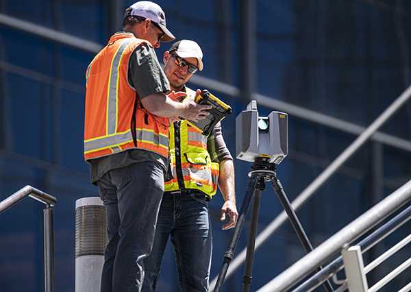
The Trimble X12 can be operated by using Trimble Perspective field software installed on a Trimble T10x tablet to enable registration and refinement of scans in the field, ensuring project accuracy and completion before leaving the jobsite. Users can also leverage Trimble’s customized onboard software menu to configure and operate the scanner.
Data is exported from the field and processed in the office with Trimble RealWorks software or third-party software. Final deliverables can be shared online with clients and stakeholders using Trimble Clarity, a browser-based data collaboration and visualization tool.
Transforming high-quality 3D data into decisions — such as using scans, models and imagery to determine the structural integrity of aging infrastructure — is streamlined with the Trimble X12 because the data can reside within the Trimble software ecosystem. This allows users to easily visualize, manage and evaluate the project throughout the entire workflow, even for beginners and new users to scanning technology.
With features including range (from 0.3 up to 365 meters) and scan speed of up to 2.187 million points per second, the Trimble X12 produces scan data and images with high quality and clarity, complementing the Trimble X7’s capabilities within the scanning product portfolio.
“The Trimble X12 puts the most advanced 3D scan and image capture within reach for a variety of skill levels,” said Jacek Pietruczanis, business area director for Scanning and Mobile Mapping, Trimble Geospatial. “The system enables advanced scanning professionals to improve their productivity with top-of-the-line performance and efficiency gains, while those new to scanning can easily unlock this advanced capability with the touch of a button.”


