No audio available for this content.

A survey consulting firm accustomed to using drones to capture data in the field recently found that data gathering was taking too long, and after just one day, the field manager knew the project wasn’t going to meet budget.
“Some of the areas were more congested than we originally planned, and we had to consider other tools to do it better and faster,” said Mike George of Downtown Design Services Inc. (DDSI).
The company turned to an laser rangefinder and got the job back on track.
To learn more about the exact processes involved in Integrating a professional measurement and mapping laser to your GIS toolbox, both saving time and enabling collection of additional attribute data attend GPS World’s free webinar on Thursday, Aug. 16: LaserGIS: Your Gateway to Collect More GIS Data in Less Time.
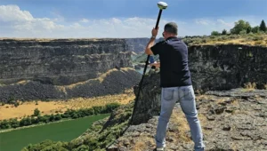
George used the Laser Technology TruPulse 360 rangefinder as a first walk-around to obtain site data for the company’s drone, identifying the peak above ground level, establishing ground control points, and setting the pre-programmed grid for the flight. The laser rangefinder significantly sped up the process without sacrificing any measurement accuracy.
“As the project went along and we started processing data,” George added, “we realized that the drone didn’t capture everything, and that some data wasn’t as high-quality as we had hoped.” Many of the smaller trees in the area were difficult for the drone camera to pick up. “We needed to know they were there. We could shoot them using the LTI laser, mark them in the field notes, and have the drafters add them in later when creating the plats for review.”
After the drone mission, the field team used the laser to quickly survey the remaining landscape. With the appropriate heights and widths, DDSI could use the missing line routine with the built-in compass as well as the height routine to get the additional measurements they needed.
“The laser rangefinder was a huge time-saver because some of these sites had up to 100 trees, and trying to identify some of these smaller ones from the drone imagery proved very tough.”
The company also saved time from not having to make a second trip to each site. “You don’t know what you’re going to get until you get back to the office. It often takes four to six hours to process the drone imagery. But after processing and analyzing data for this project, we didn’t have to go back and fill in the gaps, because we knew we had what we needed.”
After surveying only 1.5 sites on the first day, switching to a laser rangefinder brought the team up to four sites a day, and the project was completed on time and on budget. DDSI also delivered comprehensive, high-quality documentation to its client, an architectural and engineering firm.
“When we turned our imagery over to the A&E team, they had high-resolution ortho-imagery instead of only the typical black-and-white deliverables,” George said. “The team found that invaluable.”