No audio available for this content.
Stacking containers
Septentrio
Septentrio has been working on port automation projects with Kalmar, a Finnish company that offers a wide range of cargo handling solutions and services to ports, terminals, distribution centers and heavy industry. I discussed this collaboration with Stef van der Loo, market access manager at Septentrio. Following are excerpts of our conversation. For a much longer version, click here.
What are the challenges operating in a port?
In a container terminal or port, everything is interconnected and, therefore, complex. Lately, GNSS has become more popular, especially when coupled with inertial navigation, because the technology has become more capable of delivering centimeter-level accuracy even in challenging environments where the line-of-sight to GNSS satellites may be partially blocked by containers or structures.
What drives higher accuracy?
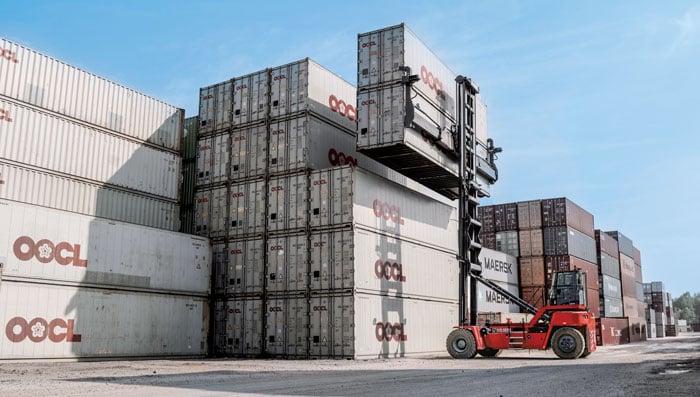
Every year, every terminal stacks a certain number of containers, but not all the information about them is given to the terminal operating system (TOS) automatically. Sometimes, operators must search for misplaced containers, which may require stopping operations and deploying additional personnel. Additionally, it is not very safe to go into these yards. This is one reason why ports began to deploy positioning systems. However, ten years ago, with meter accuracy, they were failing all the time. Now, improvements in the technology have enabled GNSS to become fit for the challenge. In terminals, you can use GNSS or INS systems for vehicle traffic management, autonomous vehicles and tasks, or to get the position of a container.
For example, when a reach stacker reaches into a stack and locks a container in place, it’s crucial to have a very reliable centimeter-level position. Errors grow as the data is processed from the control systems to the TOS. To know for certain the position of a container when it was placed in a stack errors must not exceed half a meter. Therefore, the reliability and accuracy of the GNSS/INS is crucial for container positioning.
Do you buy the IMUs and do all the integration?
We buy the IMUs mostly from Analog Devices. The integrated inertial navigation solution is our own. We focus on inertial navigation in several markets — including logistics, autonomous mining, and agricultural robotics.
What is the division of labor between you and Kalmar?
Kalmar is both an OEM and an integrator. They are a guru for the automation of logistics terminals. We work with them mainly as an integrator. They will go to a terminal, like other integrators, and install the systems and other equipment. Kalmar built a whole sensor stack with all types of sensors and integrated this in their packages, such as SmartPort. With a train-the-trainer principle, our engineers trained Kalmar employees, so they have first line control of the installations and troubleshooting. Then we are ready to support them where we can. We have a continuous feedback loop with several logistics customers for suggestions and product recommendations for the evolution of our products and services for this segment.
Straddling containers
JAVAD GNSS

One of the largest container companies in the world needed a solution to manage its straddle carriers, which are specialized container handling vehicles at ports that can pick up large containers and move them to trucks, trains, or other container stacks. This is very challenging for container terminal operators because ports are highly complex operating environments that also provide other maritime services, such as storing and managing cargo, forwarding freight, and clearing customs. To handle containers safely and efficiently, modern terminals have buildings, equipment, and cranes in addition to straddle carriers. All this infrastructure creates a lot of multipath that stresses the capabilities of GNSS receivers.
To develop and install this new system for straddle carrier vehicles, the container company turned to JAVAD GNSS and to ALLSAT GmbH, a German engineering, geodetic and electronic company founded in 1991 that has been JAVAD’s German distribution partner since 1995. To address the challenge, in 2022, ALLSAT GmbH applied a new digital twin concept to supply and support the commissioning of several hundred JAVAD GNSS rover solutions at three international seaports. This required obtaining real-time and highly accurate positional data for moving straddle carriers and uploading it to a terminal information system for control and documentation.
ALLSAT deployed a geodetic conceptual design that integrates JAVAD GNSS Delta-3S receivers and RingAnt G5T and GrAnt-G5T antennas to deliver precise surveying of two GNSS reference stations per port, then commissioned the system on all the straddle carrier vehicles from a single source. It also developed a solution employing two redundantly operating reference stations that broadcast RTK correction data for all GNSS (GPS, Galileo, GLONASS, and BeiDou) on different IP addresses/radio frequencies. All the JAVAD RTK rovers can receive and process data from both correction sources in parallel thanks to their 874 channels and parallel processors. This offers two advantages. First, it provides a comprehensive fallback in the unlikely event that one reference station fails. Second, it greatly improves the reliability, speed and accuracy of the rovers, which operate in an environment rife with signal shadowing and multipath influences.
Working closely with its client and JAVAD GNSS, ALLSAT was able to implement this project, from initial idea to verification and commissioning, in only a few weeks. The combination of redundant, multi-constellation reference stations and JAVAD GNSS multi-base RTK yielded a solution that is highly reliable and available, providing for continuous operation despite the challenging environmental conditions. Additionally, JAVAD GNSS provides firmware updates for the life of the devices, which will enable the customer to rely on this base rover solution for the next 10 years.
Tracking trains
M3 Systems

M3 Systems, a French-Belgian geolocation company founded in 1999, has long supported the R&D activities of European space and civil aviation agencies. It also markets products that it developed through its R&D activities. In recent years, M3 Systems expanded its activities into the automotive and rail sectors. To develop a new device for trains, it partnered with two Belgian companies: Logiplus, which makes onboard electronic systems for trains, and ALSTOM Belgium, a division of ALSTOM group, which builds trains and equipment for train tracks. “The objective during the product design was the development of a hybrid sensor that uses both a GNSS sensor to provide absolute positioning, and an inertial measurement unit (IMU) to compensate for environmental obstructions such as trees and urban canyons by calculating the train’s position based on its last GNSS-based absolute position,” explained Jérémy Skelton, project lead at M3 Systems.
IMUs have long been coupled with GNSS because each technology compensates for the other one’s limitations: IMUs suffer from drift and GNSS receivers from signal loss in certain environments. In theory, surveying the tracks and using odometry to monitor a train’s linear position on them would suffice to locate it. In practice, however, wheel encoders “are prone to errors because the wheels are subjected to a lot of sliding and skidding,” Skelton said. “So, we need completely independent sensors.”
This requirement led ALSTOM to propose the development of the IGLOO (an acronym for IMU & GNSS vehicle odometry) input device, which integrates all the different sensors. Logiplus designed and manufactured the hardware, while M3 Systems wrote the algorithm.
The project, which was partially funded thanks to a grant from the European Regional Development Fund and supported by the Région Wallonne of Belgium, was divided into three components:
- The software to couple the IMU and the GNSS to compute the train’s velocity.
- The auto-calibration solution, which eliminates the need for automatic calibration when starting the sensor.
- A hardware platform that incorporates a low cost IMU.
The consortium defines three kinds of zones in which a train will operate, depending on the trustworthiness in each zone of the GNSS signals. “For example, an environment with a clear view of the sky and no nearby obstacles is trustworthy,” Skelton said, “while a forest, an urban canyon, or the entry into a tunnel are not. Without GNSS support, eventually the IMU will also become unreliable.”
At very low speeds, errors must be very low, but at higher speeds a greater speed error is allowed. Operators can extract different levels of data from a GNSS receiver. To achieve a tight GNSS-INS coupling, they can use the Doppler delays and hybridize them with the IMU or use the tracking loop and set the range and Doppler. For a loose coupling, they can directly use the GNSS receiver’s positioning, velocity, and timing data. All couplings are performed by using Bayesian filters, for example the Kalman filter. “Loose coupling will give you less accuracy, reliability, and integrity, but it will also be less CPU-intensive,” Skelton said.
For data acquisition on a train, M3 Systems generated a printed circuit board (PCB) with a u-blox GNSS receiver, a Septentrio Asterix GNSS receiver, nine IMUs (which enables them to choose the best one for the use case), a reference trajectory unit that provides ground truth, and a computer that takes the data from the GNSS receivers and the IMUs. “Everything was integrated for measurement purposes on a rack on a train that runs here in Belgium,” Skelton said, “and all the data was retrieved automatically via a 4G internet connection. We have collected a few thousand kilometers traveled, a few hours of tunnels, and both trustworthy and untrustworthy GNSS signals.”
M3 Systems’ partner Logiplus designed the product to support the hybridization software and interface with the European vital computer (EVC), which monitors and continuously calculates the train’s maximum speed and braking curve. “It is critical for the EVC to have perfect knowledge of the train’s speed, which is the main reason we designed this new device,” Skelton said. “What is specific in that hardware is the computing power, the two systems (GNSS and inertial), and the data fusion algorithm, which allows the hardware to evolve. For example, we can switch to a different IMU.”
The IGLOO system complies with the specified safety requirements, contributing to a more reliable knowledge of the train speed, which reduces the risk of accidents and fatalities, improves traffic flow, and improves the efficiency and safety of the train operations, Skelton pointed out.
Surveying a railroad
Eos Positioning Systems

Network Rail, which owns and manages the railway infrastructure in England, Scotland and Wales, needed an as-is survey of up to 50,000 electrical assets along 400 miles of rails in the eastern region of the country. It turned to Arcadis, a design and consultancy firm that specializes in sustainable design and engineering services. The project required delivering accurate building information modeling (BIM) plans of the rail line to support operations and maintenance of the electrified infrastructure, while ensuring a safe working environment for the surveying teams. Using Arrow 100 GNSS receivers from Canadian manufacturer Eos Positioning Systems and Esri’s ArcGIS Survey123 and ArcGIS Hub software, Arcadis was able to efficiently capture the data with sub-meter accuracy and share it with Network Rail in real-time.
Arcadis decided to conduct a digital field survey to collect the data and to use GIS to manage it, said Gideon Simons, Associate Director of GIS and Geospatial Consultant at Arcadis. “We provided the survey teams iPads, the Esri application, and the GNSS receivers.” For corrections, it used the Ordnance Survey’s OS Net. “We found through a few assessments and testing that the Eos Arrow’s precision was good enough to meet the project’s requirements.”
The region surveyed is mostly rural but the rail line traverses some very urbanized areas. “One of the first challenges was surveying under cover in stations and in quite a few tunnels. So, we developed methodologies using georeferenced plans and imagery and taking temporary datums using GNSS outside the tunnels, to measure distance and offsets to the assets in the tunnels with measuring wheels that allowed for post-survey processing and the location accuracy required,” said Simons.
Photography was also a key to the success of the project. “In just one depot, we surveyed thousands of assets with many inside train sheds,” said Simons. “We use 360-degree cameras and train view cameras, so that we really understand where assets should be placed.”
The next stage for Network Rail is to maintain that equipment — whether it’s replacing it, bringing it up to code, or potentially installing new assets, Simons pointed out. “In the UK, we use a variety of measurements — imperial and metric. So, it’s been very helpful for the client to have just one source of truth reference that supports their work yet that can still link with other systems and ease communication with wider teams.”


