No audio available for this content.
Plus: Visual AI radar aids drone searches, and a drone is released into Hurricane Ian
Just when you imagine there couldn’t be any more twists and turns to the war in Ukraine, another one turns up. Some may recall that Estonian security forces caught an Estonian/Russian man trying to send drones to Russia. The Estonian government confiscated the shipment of DJI drones.
Now Estonia has donated those drones to Ukraine for use against Russia in the ongoing war.
Remember the drones we confiscated from a person trying to donate them for the Russian aggression in Ukraine? Well, these drones still made it to Ukraine. But the right way around and on the right side of the battlefront. https://t.co/No38Bbjkom
— Kaitsepolitseiamet (@kaitsepolitsei) October 3, 2022
Some might say that this is an example of, “What comes around goes around.” Nevertheless, everyone respects Russia’s nuclear options…
Making Drones Smart
It’s all well and good that we have all shapes and sizes of battery- and gas-powered drones, ones that take off and land vertically (eVTOL) or horizontally (generally, fixed-wing). But how do we make them smart enough to complete tasks on their own?
Artificial intelligence (AI) could be the answer. Take the Boeing Loyal Wingman drone. It is being developed to fly autonomously alongside high-end fighters, and perhaps to control other drones flying nearby. Those tasks require AI, which is being incorporated into the capabilities of drone systems.
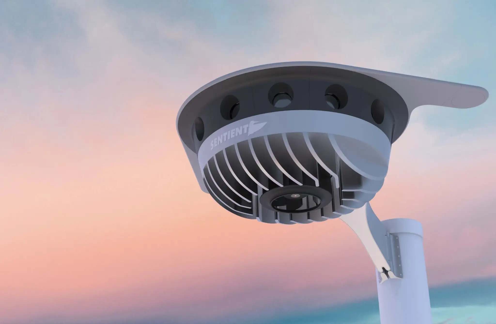
We also have immediate needs, such as search and rescue, security patrol and inspection (for commercial and military facilities, border and crowd control) and military intelligence, surveillance, target acquisition and reconnaissance (ISR/ISTAR). Along comes Sentient Vision Systems of Australia with a passive, software-based “visual radar” solution.
Sentient Vision Systems uses its digital AI processing with existing visual and infrared sensors. This combination can apparently surpass human and conventional radar capability to detect and track small moving objects.
Search and rescue at sea can be a really difficult task for people. It’s not surprising that a lot of lengthy searches end up with zilch. During a search, an aircraft flies from 20,000 feet down to 500 feet over the waves. If you have seen cabin video of air-sea searches in progress, with a searcher gazing out of the aircraft’s window for hours, straining to see something small bobbing in the sea below, it does seem like a herculean task.
As an alternative, take a long-range (>55 nautical miles) drone, such as a Boeing/Insitu ScanEagle. Hook up the scanning search camera and high-resolution nose turret to the vidar (visual detection and ranging) processing.
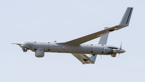
As a result, you have an autonomous airborne system that can find a person in the water from a distance of about 1.7 nautical miles, and spot a ferry deck from ~30 nautical miles. Insitu claims that conventional radar systems cannot do this. In 12 hours it can search an area of about 13,400 square nautical miles.
Several such sorties might just have found an early trace of Malaysian Airlines Flight MH370 in 2014. The Boeing 777 with 239 people on board disappeared over the South China Sea 38 minutes after takeoff on a flight to Beijing. Over three years, long-range patrol aircraft covered 46,000 square miles before the search was abandoned.
During 2015 and 2016, pieces of the airplane began washing up on the shores of countries on the Western Indian Ocean. The search would probably not have been easy even for a fleet of ScanEagles, considering the logistics and the available range of the unmanned aircraft, but major incidents might find success with vidar-equipped UAVs.
Into the Eye of the Hurricane
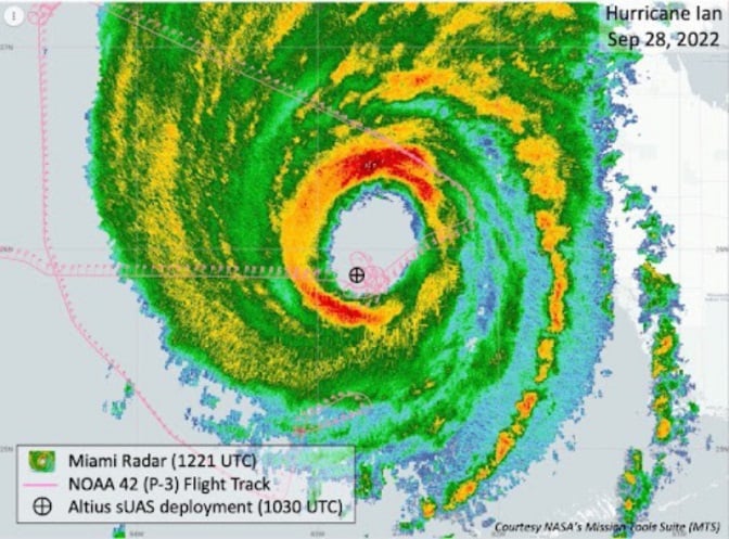
The devastation that Hurricane Ian wrought in Southwest Florida has been terrible. A shark swimming up a street in Fort Meyers illustrates the degree of flooding left from landfall of the category 4-5 hurricane.
Ian was the strongest hurricane to make landfall in the United States in decades, with extremely high winds and strong storm surge. I sat through the storm 75 miles to the North, and it was one scary hurricane even there. I can’t sympathize enough with the residents of Lee County, who only received a warning to evacuate one day before it hit them.
Nevertheless, the National Oceanic and Atmospheric Administration (NOAA) had its Hurricane Hunter Orion aircraft up to investigate on Sep. 28 as the storm came in from the Caribbean. Despite bad turbulence, the P-3 aircraft flew into the upper regions of the Hurricane and launched an Altus-600 27-pound drone into the eye at 4,500 feet. With a 275-mile range at up to 100 mph, the aircraft crew controlled the small drone, using it to collect data on wind speed, pressure, temperature and humidity.

During the two-hour mission, the Altus drone flew into the eye wall, where winds of 187 mph were detected at altitudes between 2,300 and 200 feet. It’s not exactly clear whether the drone survived.
While information gathered may have assisted with the immediate forecasting for us Florida folks on the ground, the real scientific value comes from feeding the data into National Hurricane Center models for storm detection and analysis to keep us safer in the future.
Wrap up
To sum up, this month we saw drones destined for Russia sent to Ukrainian forces. Vidar artificial intelligence on Insitu ScanEagle drones promises huge gains for search and rescue. And, once again, a NOAA crew flew directly into the eye of a hurricane, this time releasing a drone to aid in gathering essential storm data.
Tony Murfin
GNSS Aerospace


