Listen to this content
In my February GPS World newsletter, I highlighted that the National Geodetic Survey (NGS) staff participated in GeoWeek 2026 in Denver. They engaged with geospatial product and service users and provided the latest updates on the status of the modernization. On March 25, 2026, as President of American Association for Geodetic Surveying (AAGS), I participated in a GeoWeek webinar titled “NSRS Modernization is Here: What Surveyors Need to Know Now.”
The webinar was based on presentations by NGS and others at GeoWeek 2026. The webinar provided the status of NGS’s new modernized NSRS and the professional societies (AAGS, ASCE, ASPRS, and NSPS) addressed how they are helping others to prepare for the change. It is available to everyone under the “On-Demand Webinars” section of Geo Week News here: https://www.geoweeknews.com/webinars.
This newsletter will highlight the 2026 Society of Land Surveyors of Iowa (SLSI) Annual Meeting, which I had the opportunity to attend at the SLSI 89th Annual Land Surveyors Conference, held on March 4-6, 2026, in Ames, IA.
First, at the end of February’s newsletter, I shared my main thoughts and concerns that I believe NGS and the broader community should carefully consider before NGS adopts the new modernized NSRS.
I encourage you to watch the GeoWeek Webinar mentioned above for the latest update from NGS on the modernized NSRS.
I have already shared my concerns directly with NGS, but it’s important that they also hear from the user community. You can provide feedback via NGS.Feedback@noaa.gov, user forums, or upcoming webinars and Q&A sessions.
Although I covered these points in my last newsletter, I believe they remain important, so here’s a shorter version of my key thoughts and concerns:
- Timeline uncertainty: Clearer, more frequent milestone updates (beyond the Track Our Progress page) would help manage expectations.
- OPUS and processing continuity: NGS should commit to a longer grace period — or ideally a defined parallel support window — for legacy OPUS tools (particularly OPUS-Projects 5) after the official adoption of the modernized NSRS.
- Data access and usability in the new DDS: The new web-based system needs to provide robust APIs or export options that are comparable to those in current datasheets/legacy tools.
- Transformation tools and legacy data handling: Users need confidence that transformations minimize errors, especially in deformation-prone areas.
- Communication and outreach: Case studies, training resources, and FAQs that describe real-world practical examples, tailored to common workflows, need to be developed and documented.
Again, I encourage anyone reading this (including NGS staff) to test the beta products actively, submit detailed feedback, and participate in forums/Q&As. The community input will make or break the success of this once-in-a-generation update
Regarding the 2026 Society of Land Surveyors of Iowa (SLSI) Annual Meeting, I was grateful to receive the invitation and truly enjoyed attending. As always, I came away from this gathering of surveyors with valuable insights.
The conference was exceptionally well organized, with plenty of time for meaningful interactions among attendees, exhibitors, and speakers. In total, 285 people attended.
As expected, I presented on the new modernized NSRS. The topics I covered are listed in the box titled “Topics Addressed During my ½ Day Session on the New NSRS.”
I was fortunate to have Ben Sullivan, Seiler Geospatial, set the stage for my presentation by providing a short introduction to the new modernized NSRS. He provided an overview that addressed: (1) what the new national datum is, (2) how it will affect the geospatial community, and (3) how users can prepare for it once officially released by the NGS.
Topics Addressed During My Half-Day Session on the New NSRS
- What to expect between NAD 83 (2011) and NATRF2022 in Iowa?
- Why is NGS modernizing the NSRS and what are the expected coordinate changes in Iowa?
- How are reference frames and datums defined?
- What are the differences in CORS coordinates between the Multi-year CORS Solution 2 (MYCS2) and Multi-year CORS Solution 3 (MYCS 3) in Iowa?
- What does NGS mean by time-dependent coordinates and why is it necessary for the new, modernized NSRS?
- How will plate tectonics be handled in the new, modernized NSRS?
- What’s the difference between NAD 83 (2011) epoch 2010.0 and NATRF2022 epoch 2020.0 in Iowa?
- What are the differences between Reference Epoch Coordinates (REC) and Survey Epoch Coordinates (SEC)?
- What’s the difference between ITRF2020 and NATRF2022 in Iowa?
- How do you use NCAT to convert between reference frames and compute State Plane Coordinates?
- Why is it important to have the appropriate metadata of your old projects for the implementation of the new, modernized NSRS?
- What to expect between NAVD 88 and NAPGD2022 in Iowa?
- How will orthometric heights be determined in the new, modernized NSRS; that is, how will NAPGD2022 orthometric heights be determined in the new NSRS?
- Review of Computing GNSS-Derived Heights
- What’s the estimated difference between NAVD 88 and NAPGD2022 epoch 2020.0 in Iowa?
- How will NAPGD2022 Orthometric heights be determined using GEOID2022?
- What are the differences between GEOID2022 models and Hybrid Geoid Model GEOID18 in Iowa?
- How will NAPGD2022 affect the National Flood Insurance Program and the Elevation Certificate?
- Updates from the National Geodetic Survey at GeoWeek 2026
Many of the topics covered in my session have been addressed in previous newsletters. For example:
- My June 2020 newsletter explained how NAPGD2022 orthometric heights will be determined using GEOID2022, and why NGS will require GNSS occupations on primary marks when submitting leveling projects.
- My October 2022 newsletter discussed NGS’s Multi-year CORS Solution 3 (MYCS 3).
- My August 2022 newsletter covered Reference Epoch Coordinates (REC) and Survey Epoch Coordinates (SEC).
- My March 2026 GPS World newsletter addressed the updates from NGS presented at GeoWeek 2026.
Whenever I attend conferences, I visit exhibitors to ask about the modernized NSRS. Many had heard of it, but only a few could explain the differences or how their company will adapt products and services to the new reference frames. Several said their company is aware of the change but couldn’t specify how or when they’ll respond. I encourage all users to contact their equipment and software providers and request a detailed plan for addressing the new NSRS.
I want to highlight two sessions I found both very interesting and important for surveyors. They were presented by Todd Horton, PE, PLS of Meridian Geospatial.
| Meridian Geospatial Consulting Todd Horton, PE, PLS, is the owner of Meridian Geospatial Consulting, LLC. Todd has provided technician training and continuing education seminars for the land surveying industry since 2005. Todd served in the US Air Force and with the Illinois Department of Transportation in planning, design, construction, surveying and maintenance of civil engineering projects including commercial structures, airfields, utility systems and highways. He joined the full-time faculty at Parkland College in Champaign, IL, where he taught land surveying and construction management courses for 25 years. Todd founded the land surveying associate degree program at Parkland College in 2001. Having retired from full-time teaching, Todd has joined Farnsworth Group Inc. as a part-time senior project land surveyor. You can reach him at todd@meridiangeospatial.com. (From https://www.meridiangeospatial.com/) |
One of Horton’s presentations was titled “Professional Ethics.” In it, he highlighted how new technology is reducing the size of surveying crews and improving overall efficiency. However, this comes at the cost of reduced opportunities for mentoring the next generation of survey technicians and surveyors.
I’ve recreated his diagram below to illustrate the issue.
Crew Size vs. Mentorship
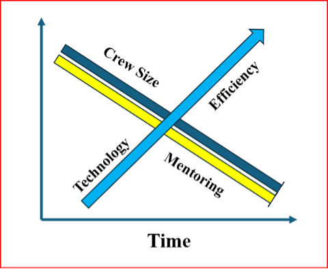
As shown in Horton’s diagram, while new technology increases efficiency and allows for smaller survey crews, it also reduces the time available for surveyors to mentor technicians and the next generation of professionals.
Training and mentoring are extremely important for the continued growth and development of individuals in the surveying and mapping community.
He explained that the world consists of two types of individuals: specialists, who have a narrow skill set and limited opportunities, and generalists, who possess broader knowledge and skills, think multi-faceted, and are forward-looking.
He emphasized that a professional surveyor typically needs 3 to 5 surveying technicians to successfully complete a project. While professional surveyors regularly attend training sessions (as evidenced by many participants at this conference), technicians often have little or no access to formal training.
He advocated that technicians should be trained as generalists. This means equipping them not only with better tools and equipment, but also with a strong foundational knowledge and skill set — especially understanding the “why” behind the “how.” This deeper knowledge enables them to prevent problems before they occur and effectively troubleshoot issues when they arise.
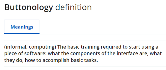
I addressed this same concern in my November 2022 newsletter, where I warned that the industry is creating a growing number of “buttonologists” — technicians who rely heavily on pushing buttons without deeper understanding.
This trend concerned me then, and it still does today. That’s why I was especially pleased to hear Todd directly address the issue and offer a clear path forward for improving training and development for both technicians and surveyors.
Excerpt from November 2022 GPS World Survey Scene Newsletter
A participant at one of my workshops stated that “GPS has made geodesists out of all of us.” In my opinion, the advancements in GNSS equipment and processing software provided some users with a “false sense of knowledge or security” that they understood what was happening within the “black box.” One of my colleagues at NGS said that the new equipment and software programs were creating a field force of “buttonologists.”
He highlighted that the surveying community needs more technicians than licensed professionals. As a result, we should prioritize training and development for technicians. This is a constant need and would help reduce turnover rates.
He also emphasized the importance of growing future professionals from within the technical ranks. Doing so would increase technicians’ motivation and desire for advancement, making them more eager to take on greater responsibility and pursue professional growth.
He provided the following training approaches:
- On-the-job training
- Self-guided study
- Continuing education resources
- Online content
- College courses
- Live skill training
He noted that these investments in training will yield the following advantages in professional and organizational development:
- Enhanced employee skills
- Opportunities for career advancement
- Stronger organizational performance
- Sustained competitiveness via continuous learning
- Increased productivity
- Higher employee retention
- A thriving culture of innovation
Horton also discussed a training program he’s involved in that not only trains technicians but also includes training for the trainers. This “train-the-trainer” approach helps accelerate the program’s growth and impact.
For more information, I encourage you to reach out to Horton directly for additional details about his programs and his ideas on improving technician training.
Horton also gave a very good session on a very difficult subject, that is ALTA/NSPS “Relative Positional Precision (RPP).”
As a side note: see the box titled “Top 5 Key Changes in the 2026 ALTA/NSPS Standards” for the key changes in the 2026 ALTA/NSPS standards. Detailed information on the ALTA/NSPS 2026 document can be downloaded at the following NSPS weblink: https://nsps.us.com/page/2026ALTA.
Top 5 Key Changes in the 2026 ALTA/NSPS Standards
- Precision (RPP): The clarification of RPP is a core technical change. While it does not alter how surveys are performed, it improves consistency and understanding of measurement quality expectations across the profession.
- Shift from “on the ground” to “practices generally recognized as acceptable” (Sections 5 & 6): This is one of the most significant forward-looking changes. It explicitly accommodates modern technologies such as drones, lidar and future tools (including AI), without locking the standards to specific methods.
- Expanded guidance on sourcing title evidence when a recent title commitment is unavailable: This change directly affects research responsibilities and risk management, especially on projects where title information is incomplete, delayed, or unconventional.
- Requirement to note evidence of possession or occupation along the entire perimeter: This materially broadens what must be considered and documented in the field, regardless of how close that evidence is to the boundary line – an important title-risk issue.
- Clarification that verbal (“parol”) statements must be noted when made: This adds explicit documentation requirements tied to conversations with landowners or occupants, which can be critical in dispute resolution and liability defense.
Todd started his presentation by providing RPP as defined by ALTA/NSPS (2026):
- Relative Positional Precision (RPP) is the acceptable indicator of measurement quality on an ALTA.NSPS Land Title Survey.
- It is defined as the length of the semi-major axis, expressed in meters or feet, of the error ellipse of the line connecting the monuments or witnesses marking adjacent boundary corners of the surveyed property at the 95 percent confidence level.
His session was organized into nine sections labeled RPP Keys for Success:
- Choose one equipment and a measurement method based on the accuracy needs of the project.
- Use well-adjusted instruments and procedures to eliminate systematic errors in measures.
- Make internal checks to detect blunders in measurements.
- Make redundant measurements to have a large degree of freedom.
- Access the quality of control that will be used.
- Avoid weak network geometry.
- Organize all field measurements for software input.
- Establish standard errors for all observation conditions.
- Adjust and analyze results.
In these sessions, he covered fundamentals including:
- precision vs. accuracy,
- systematic vs. random errors, and
- absolute vs. relative accuracy.
Horton emphasized that systematic errors follow mathematical or physical laws and can usually be modeled or reduced with proper procedures, while random errors persist after blunders and systematic errors are addressed. By using improved equipment and proper procedures to detect, reduce, or remove errors, users lower the uncertainty in their results — reducing uncertainty should be a goal for any product or service.
Many people are familiar with the classic bow-and-arrow (or target) diagram that illustrates the difference between precision and accuracy.
I recreated Horton’s diagram on this topic because it effectively highlights that our ultimate goal in surveying is to reduce uncertainty in our results.
As the diagram shows, simply repeating observations can give the appearance of good precision, but it does not guarantee accuracy. The result can be high precision with low accuracy — and therefore a large remaining uncertainty.
Precision vs. Accuracy
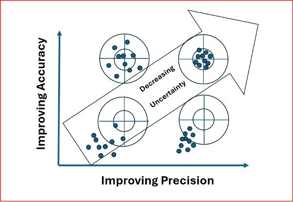
Recreated from Todd Horton presentation
Todd noted that most RPP values are derived from a properly weighted least-squares adjustment. Many manufacturers’ software packages now use least squares to estimate RPP, making it essential to provide accurate error estimates so the data are correctly weighted in the adjustment.
To illustrate this point, he provided clear examples of the following concepts:
- Determining the appropriate error estimates for data,
- Measuring errors,
- Degrees of freedom and redundancy,
- Significance and confidence intervals,
- Appropriate weights of measurements,
- Propagation of errors, and
- Statistical tests for analysis of data and results.
He explained how to compute the allowable RPP and offered practical advice on selecting the appropriate equipment and measurement methods, tailored to the accuracy requirements of the project.
In my opinion, this topic can be challenging to grasp without a strong mathematical background. Todd did an excellent job explaining the concepts clearly while avoiding excessive mathematical detail.
To illustrate the RPP, Todd presented two real-world examples of combined networks using GNSS and traverse data. The first example combined GNSS with an open traverse using EDM, horizontal, and zenith angles. The second example incorporated RTK GNSS vectors with a closed traverse using classical survey data.
This was an excellent session. I highly recommend reaching out to Todd for more details about his programs and insights.
I want to thank the organizing committee of the 2026 SLSI Annual Meeting for the kind invitation to participate in their conference. I truly enjoyed the experience and came away with many valuable insights from this excellent gathering of surveyors.


