No audio available for this content.
Datumate, a photogrammetry solution and 3D mapping software developer, has released its updated DatuSurvey 5.5 software, which offers 2D vectorized measurements and 3D point cloud models.
According to the company, with the updated software, users can now process thousands of images locally in an accelerated mode while maintaining survey-grade accuracy and professional engineering results. Organizations can also deploy Datumate’s solutions on single or multiple computers and take advantage of the accelerated and user-friendly processing of the project field data.
In addition, DatuSurvey 5.5 can process large amounts of drone imaging data locally and quickly. The software can also achieve survey-grade accuracy and geo-reference the model quickly and easily, the company added. Finally, it can plan and execute consecutive drone missions on unmapped and frequently changing areas.
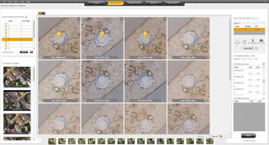
According to Datumate, its team improved the geo-referencing workflow of the software when using ground control points. Users can now quickly and easily mark ground control points using zoomed-in image projections.
The company also added the ability to import coordinates to DatuFly Professional in addition to on-site or on-map mission planning. This will enable an efficient and accurate drone mission execution on specific and designated areas without depending on satellite and map source views, Datumate said.


