No audio available for this content.

Three weeks ago, GPS World / Geospatial Solutions held a webinar highlighting new technologies for imagery and data capture. The webinar had four presenters: Paul Smith of CycloMedia, Ted Ralston with Soft Power Solutions, Peter VanAmburgh from IIF Data, and John Ciampa CEO of Alta. You can view a YouTube video of the session. Because webinar time is limited, we couldn’t cover the technologies in detail, so I’m covering some of the technologies one column at a time.
In February, I devoted my column to CycloMedia, so you may want to review that material if you want more detail. This month I want to delve into the Alta balloon system that was presented by John Ciampa, the CEO of Alta. John was the original patent holder of Pictometry, the revolutionary high resolution geo-referenced metric oblique imagery system. He and Steve Schultz took the concept from theory to a practical functioning system that has been an industry standard for over 10 years.
John continues his research, dividing his time between the Rochester Institute of Technology (RIT) and Florida International University (FIU) while also working with the National Science Foundation (NSF). Although Pictometry was very successful, he also understood the limitations and cost of a manned aircraft as a capture system, especially for disaster response. Pictometry was a very capable system, but John felt that what was needed was a system that had a “lighter footprint” figuratively and literally. John took his knowledge and experience, and combined it with the latest developments in micro-miniaturized technology, to develop a system that was elegant in its simplicity and usefulness.
The Platform
Simply put, the Alta balloon is a steerable oblique geo-referenced camera system attached to a weather balloon. By using a balloon, John solved several problems associated with manned aircraft — cost, image quality, and accessibility. A balloon is cheaper than an aircraft, doesn’t require a licensed pilot, is more easily deployable, and can “fly” at lower altitudes.
Even a small aircraft is expensive, and requires a trained pilot and complex support logistics. A small used aircraft can run $50,000 to several hundred thousand dollars. Additionally, most high-end aerial imagery systems generally require expensive FAA-approved modifications of the airframe. This adds cost, and limits the aircraft that can be used. Equipped with Pictometry cameras and electronics, a total aircraft capture system can easily cost $300,000 and up.
A significant factor during disaster response events is transportability and support. Past experience has shown that it can be very difficult to transport and operate even small aircraft in disaster regions, especially if the damage is widespread. Fuel and ground support in disaster sites can also be a serious limitation. By comparison, a balloon system can be carried in a suitcase, shipped quickly, and set up in less than an hour. Since the cost is in the range of several thousand dollars, multiple systems are practical and can be deployed in numerous remote locations. Equally impressive is that operators can be trained in less than an hour.
But don’t get the impression that Alta is as simple as strapping a digital camera to a balloon. Achieving the image quality, accuracy and dynamic performance of the Alta system requires a very sophisticated package, including the balloon, controls, communications and sensors. The balloon system is actually two balloons, one within the other, an outer balloon and inner lift gas balloon. The outer balloon provides some external protection while presenting a consistent profile. The inner balloon provides the lift and is filled with either hydrogen or helium.
The altitude is remotely controlled by venting lift gas to descend or by dumping water ballast to ascend. An onboard computer and sensors can also maintain altitude autonomously. When the balloon is brought down, a tethered weight drops to several feet under the balloon. The weight contacts the ground first and “anchors” the balloon and payload for retrieval. This keeps the balloon and payload off the ground, and also makes it easier to spot.
There are several modes of operation that are determined by the operator prior to launch:
- “Path Mode”: The balloon is released, ascending to the programmed altitude, then drifting with the wind currents before descending back to the ground.
- “Patch Mode – single tether”: Used to launch and retrieve the balloon. The balloon ascends to altitude, and its position is downwind based on the strength of the wind acting on both the balloon and tether.

- “Patch Mode – multiple tethers”: Very precisely controls the location of the balloon over a limited area. This is very similar to the overhead cameras used in televised football games but in reverse, since the balloon wants to fly up.

The system can also be equipped with a parachute for emergency landings, a solar trickle charger for extended missions, and even a quadcopter that can steer the balloon to specific target areas. The lift capability of the balloon permits significantly longer duration flights than a quadcopter alone. A detailed operator’s manual is available for review at the Alta website — look for the Operators Manual.
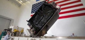
The Payload
The modular payload is complex, but also lightweight and compact thanks to the latest developments in miniaturization. It consists of a precision GPS unit, inertial measurement/navigation unit (IMU), an onboard computer, environmental sensors, Wi-Fi communications, and an aimable high-resolution camera on a stabilized gimbal. The camera can be RGB, night vision or even multi-spectral. The imagery is downloaded as captured and delivered almost real-time.

The Output
Because the balloon floats at low altitudes, image resolution is an impressive “game changer.” Here is just one example comparing a 4-inch pixel Pictometry/Bing image taken from 3,000 feet to a 1-centimeter pixel Alta image of the same location taken from several hundred feet.

Similar to Pictometry, the system uses GPS and IMUs to very accurately determine the camera location and attitude. That information, linked via algorithms to the captured imagery, results in imagery that is geo-referenced, measurable and available with full metadata, including the time of capture. I can’t over emphasize how important this is. Having instant access to imagery is nice, but having that imagery already geo-referenced means that the imagery can be quickly and easily imported into a GIS and overlaid with legacy GIS data for instant analytics.
The system has been used for many mundane applications such a real estate, agriculture, construction/engineering and event planning. More critical applications include crime-scene monitoring, surveillance and disaster response. Recently, in response to a South Florida Mall shooting, police launched an Alta balloon to view the crime-scene location. The imagery was instantly and continuously sent to police station computers and mobile devices of responders en route to the mall for pre-planning of their response. Viewing rooftops and walkways for victims and perpetrators, a near real-time operational picture was provided to police before putting themselves and others in harm’s way.

Dolphin Mall Sweetwater Florida, May 14, 2014, 6:05 a.m.
The Potential
I’m especially excited about the potential lifesaving use of Alta balloons. On numerous occasions I was involved in emergency response actions, and the dominant overarching need was high-quality imagery that could be combined with legacy data and imagery as close to real-time as possible. This system answers that need, and at a low cost. I could envision several Alta systems in every county nationwide ready to deploy on a moment’s notice. I believe that these units would be especially valuable for disaster response in second- and third-world countries. Dozens of Alta systems and trained operators could be delivered on short notice to major disaster sites, providing almost real-time common operational pictures for first responders. The added advantage is the very light need for logistics and support.
Military applications could be equally important. The silence of balloons coupled with a small visibility profile, including almost total invisibility at night, makes them ideal for reconnaissance and surveillance. The relatively low cost of the platforms also permits them to be expendable. In a tethered mode, the persistent “eye in the sky” could serve as a deterrent, or at a minimum make hostile activity more complicated for the perpetrators as they try to hide activities from the balloon. The “light” logistics and fast operator learning curve are just added benefits.
A key question raised during the webinar was FAA control. John indicated that the FAA does not consider the Alta balloons in a tethered mode subject to their control, and is currently reviewing it in a drift mode. John further amplified that the very low altitude of operation and dual control of descent should also exempt the drifter from FAA involvement. Alta could provide a significant advantage where UAS operations are restricted or not practical.
In a recent book, “Smaller Faster Lighter Denser Cheaper” by Robert Bryce, reviewed in the Wall Street Journal, the author argues that a similar dynamic, making less do more, drives virtually every technological change that has created the modern world, from cars and airplanes to advanced medicine, strategic metals and the iCloud. Alta balloons are certainly a good example.
I was an early proponent of Pictometry because, unlike abstract GIS data and ortho imagery, the metric oblique imagery was easily understood by non-GIS users. I saw many examples where it saved lives because police and firefighters were able to form and exploit a common operational picture quickly. Alta has me equally excited because it brings that same capability to users with a much simpler system that delivers almost real-time imagery at a cost anyone can afford. This technology is going to help a lot of people.


investigationstoronto.com
Easy to check out, easy to read…heck I had to leave
a commment!