No audio available for this content.
News from the European GNSS Service
The huge value of the Galileo Search and Rescue (SAR) service was underlined in a live demonstration off the coast of Belgium on Sept. 26.
Operation Shark Bait showed how this vital service can quickly trigger a rescue operation and save lives at sea. Despite a grey day and choppy sea conditions, an emergency rescue was initiated in just over three and a half minutes after intrepid “volunteer victim,” Australian broadcaster and explorer Tara Foster, operated her Galileo-enabled SAR beacon from a small life raft buffeted by the waves just offshore from the port of Ostend.
Operation Shark Bait was a specially designed demonstration of the capabilities of the Galileo SAR service that took place around the new state-of-the-art Belgian Maritime Rescue and Coordination Centre (MRCC) in Ostend with an invited audience of VIPs and media. The whole operation was streamed live over YouTube and the Europe By Satellite (EBS) TV service.
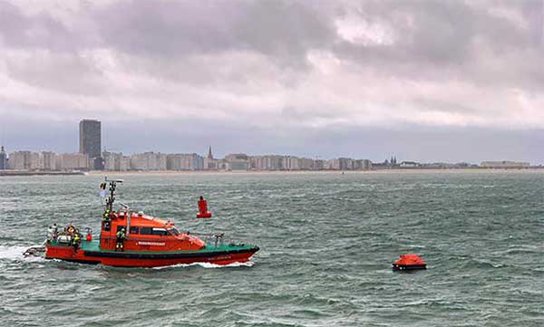
The scenario was simple. Tara was left alone at sea in a small life raft, but with a 406-MHz Cospas-Sarsat personal locator beacon (PLB). On activating the beacon, the stopwatch started. The time to receive the distress signal, compute her position and alert the relevant rescue authorities was recorded. The Belgian fast rescue boat ORKA R6 then dashed out to sea to pick her up.
Subsequently, a NH90 Cayman SAR helicopter from the Belgian 40th squadron was also scrambled to help transfer “injured” Tara to hospital.
Shark Bait was a great success with just 3 minutes 32 seconds elapsing from Tara activating her Galileo-enabled personal locator beacon (PLB) to the moment commanders at MRCC could dispatch the ORKA to her location.
The location, with an initial accuracy of 100 metres, is provided by the Galileo receiver inside the PLB to the Galileo satellites in view. The Galileo satellites then forward this information to the Cospas-Sarsat infrastructure, where the position is validated.
“The PLB used was developed under one of our Horizon 2020 projects and is the first Galileo-enabled beacon on the market,” said Fiammetta Diani, head of market development at the GSA.
Time saver, life saver
The day started at the MRCC in Ostend with a visit to the operations centre, an inspection of the ORKA Fast Rescue Boat and a chance to talk to Tara Foster before she was “castaway” on the waves.
Dries Boodts, deputy nautical director at MRCC, described the role of the center, which has a single focus on safety at sea. “The globe is divided into Search and Rescue Regions (SRRs),” Boodts said. “The MRCC oversees the Belgian maritime region that extends up to 47 miles off the Belgian coast.”
The region includes major shipping lanes and two large offshore wind energy parks. The MRCC deals with around 450 incidents each year involving a range of craft and issues from collisions at sea to war munitions recovery. It can call on an assortment of assets including its own rescue craft, police and navy vessels and the Belgian air force and the MRCC collaborates extensively with authorities in neighbouring countries.
Galileo is Europe’s contribution to upgrading Cospas-Sarsat, the global satellite-based search-and-rescue system. Since its introduction in 1981, Cospas-Sarsat is estimated to have saved 45,000 lives.
The current MEOSAR (Mid-Earth Orbit Search and Rescue) upgrade is based on the EU’s Galileo satellite constellation that carries a dedicated Cospas-Sarsat payload for the 406-MHz distress beacons that give users free access to global system.
The addition of Galileo (and other GNSS satellites) to the system has already enabled a dramatic increase in performance in terms of better accuracy to locate activated distress beacons and vastly improved global coverage.
“With the Galileo system, all parts of the world will be covered at least every 10 minutes — previously this was up to four hours — and guaranteed location accuracy is reduced from 10 to 2 kilometers,” explained Jolanda van Eijndthoven from the European Commission.
As well as the 23 SAR payloads currently provided by Galileo, with more to come, the EU also provides ground infrastructure including MEO Local User Terminals (LUTs) to pick up the signals relayed from the satellites. These LUTs are not just in Europe, and a fourth facility is o be opened soon on La Reunion island to improve coverage across the Indian Ocean.
Return link reassurance
From the end of the year the Galileo system will also provide a Return Link Service (RLS) that will be able to send an acknowledgement to the victim that their distress signal has been received and help is on its way. This new ability to provide reassurance should deliver a valuable psychological lift to victims and further boost survival rates.
“The PLBs developed under our Horizon 2020 projects will be the first ones on the market to have the RLS capability,” said Fiammetta Diani.
Back on dry land, Tara confessed that the simulation had felt very real to her. “The scariest part was the transfer to the helicopter from the rescue boat,” she said. “The winch was like a lift without a floor and very fast! Stepping from the flimsy life raft to the ORKA was also not easy – those waves were high!”
“The operation went just like clockwork,” concluded Paul Flament Head of the Galileo and EGNOS unit at the European Commission’s DG GROW.


