No audio available for this content.
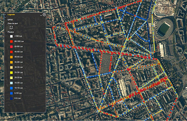
The BYes “GetYourSpace” service collects and analyzes lighting in urban environments using a GIS-based approach and the Trimble MB-TWO GNSS module.
One of the most visible services provided by cities and municipalities is the illumination of streets and public spaces. To optimize the use of public funds, cities need timely, comprehensive information on how their lighting systems are working. Operators use the data to monitor system performance and plan maintenance, repairs and upgrades.
Gathering data on street lighting is often performed manually. Technicians carrying photometers and clipboards visit individual light poles to collect information on the lighting output. The work, which must be performed at night, is slow and labor-intensive and can pose safety issues for the field technicians.
GetYourSpace debuts
The French company Bouygues Energies & Services (BYes) provides solutions that help cities operate efficiently. The company recognized the need for a mobile, automated system to collect lighting data and produce results accessible by a variety of users.
The opportunity evolved into the BYes “GetYourSpace” service, which collects and analyzes lighting and other facets of urban environments. It uses a GIS-based approach to provide mapping and visualization functions.
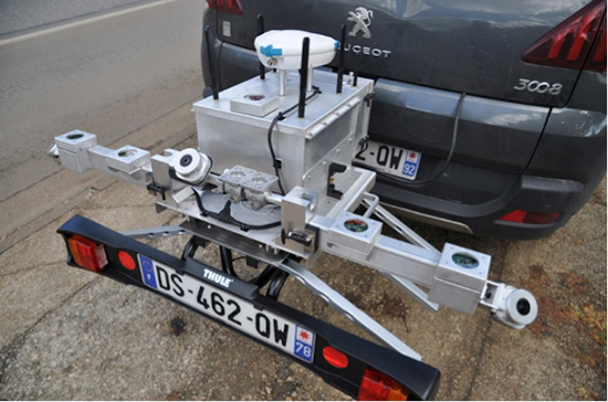
BYes set out to develop a compact platform that could detect and measure sources and characteristics of light. To present information using GIS, the GetYourSpace platform needed to include reliable geolocation. BYes called on Cadden, a French developer of location systems for marine and industrial applications, to provide the positioning component for the GetYourSpace platform.
Reliable geolocation

For the GetYourSpace collaboration, Cadden proposed a version of its G-Nav smart antenna, a product from Cadden’s GEOD brand. The G-Nav is built around a Trimble MB-TWO compact OEM GNSS module, an advanced GNSS receiver in a compact form designed for easy integration. The MB-TWO provides a range of GNSS configuration options, which allowed Cadden to produce a positioning system tailored to the BYes requirements.
The communications ability of the MB-TWO enabled Cadden to streamline the development process. The module provides multiple input/output options and can be configured and controlled using a web interface as well as a simple ASCII command set. Cadden leveraged the module’s small size and low power requirements to embed it into a compact, robust GNSS unit that combines power and data into a single connection.
High-speed data collection
Cadden’s implementation of Trimble GNSS provided key enabling technology for GetYourSpace. With an area of 1 square meter, the mobile platform includes the GNSS, light and environmental sensors, system controller and data logging.
The MB-TWO rapid update rate (up to 50 Hz) enables the GetYourSpace platform to capture accurate information even while moving at high speed. The low-power, lightweight platform can be mounted on a small car or towed behind a bicycle and requires minimal interaction with the operator or driver.


