
Listen to this content
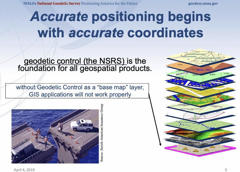
A National Geodetic Survey (NGS) slide illustrating the importance of accurate positioning shows a striking image of a bridge that fails to connect due to mismatched coordinates. While this may sound far-fetched at first, the significant differences between the current National Spatial Reference System (NSRS) and the new modernized NSRS make it a real risk — especially if users don’t supply the proper metadata for their coordinates and reference frames.

The new NSRS is almost here
I know I’ve been saying this for quite some time, but it’s truly getting close. My Oct. 2025 GPS World Survey Scene newsletter highlighted some of the significant horizontal and vertical coordinate changes expected between the current NAD 83 (2011)/NAVD 88 and the upcoming NSRS (NATRF2022/NAPGD2022).
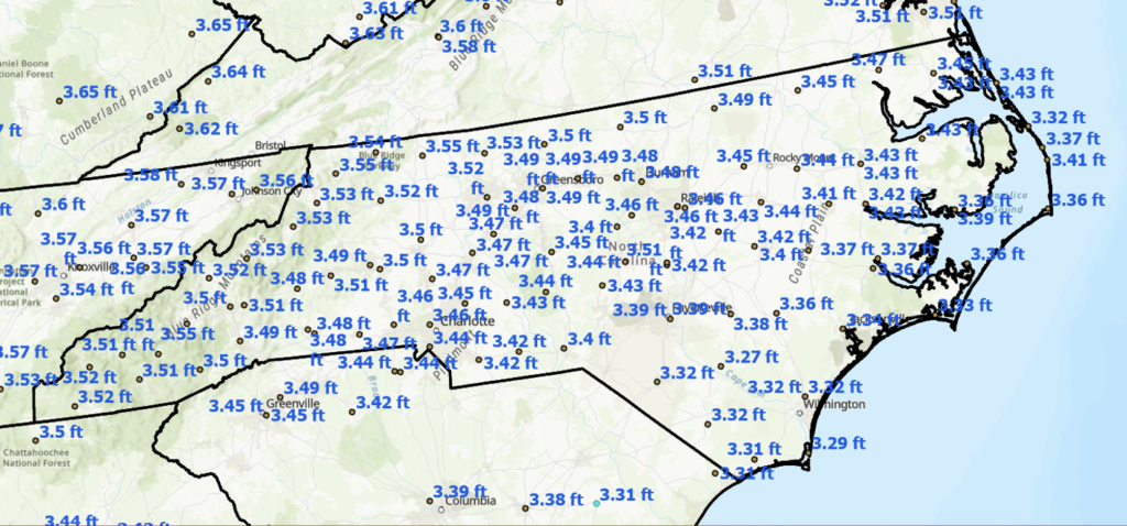
The figure from that newsletter, titled “Approximate Differences Between NATRF2022 (Epoch 2020.0) and NAD 83 2011 (Epoch 2010.0) in NC,” illustrates the approximate horizontal coordinate differences — exceeding 3 feet in some areas — based on NCN CORS data. (Note that the units are in ft.)
Providing feedback to NGS
In my newsletters and seminars, I regularly emphasize the importance of users providing feedback to the NGS on their products and services.
There are clear signs that the NGS feedback system is working. NGS is actively listening to its users and is developing new tools to help support the implementation of the modernized National Spatial Reference System (NSRS). Professional agencies and state working groups are actively providing valuable input on both current NGS products/services and the beta versions being prepared for the new NSRS.
I encourage all users to take advantage of NGS’s feedback system. Most NGS product webpages include a “Provide Feedback” statement. For example: “To provide feedback on any of the content on this site, please email ngs.feedback@noaa.gov.”
As a direct result of user feedback and ongoing discussions, NGS recently advertised a contract opportunity for NGS CORS Processing Development. I will describe this project in more detail later in the newsletter.
But first, what constitutes good feedback to NGS?
In my view, the most effective feedback should:
- Propose workflow improvements to NGS programs and services that help streamline the work of geospatial professionals,
- Identify and clearly illustrate potential software errors or issues, and
- Most importantly, recommend new products and services that will help users successfully implement the modernized NSRS.
NGS cannot act on every suggestion, but they certainly cannot act on those that are never submitted. So please share your feedback — NGS isn’t just hearing; they’re truly listening.
NC 2022 Reference Frame Working Group Update
In my May 2026 newsletter, I provided an update on the North Carolina 2022 Reference Frame Working Group (NC 2022 RFWG), which is actively preparing guidance for North Carolina’s geospatial providers and users.
In my October 2025 GPS World Survey Scene newsletter, I highlighted the excellent work of Dr. Dana J. Caccamise II, NGS Regional Geodetic Advisor, who has developed practical guidance materials to help geospatial professionals prepare for the implementation of the new NSRS.
In recent discussions with Dr. Caccamise, we emphasized the critical importance of computing coordinates in the new reference frames — such as NATRF2022 (epoch 2020.0) — for non-NCN stations as part of a smooth rollout of the modernized NSRS.
How do I know NGS is listening to user feedback?
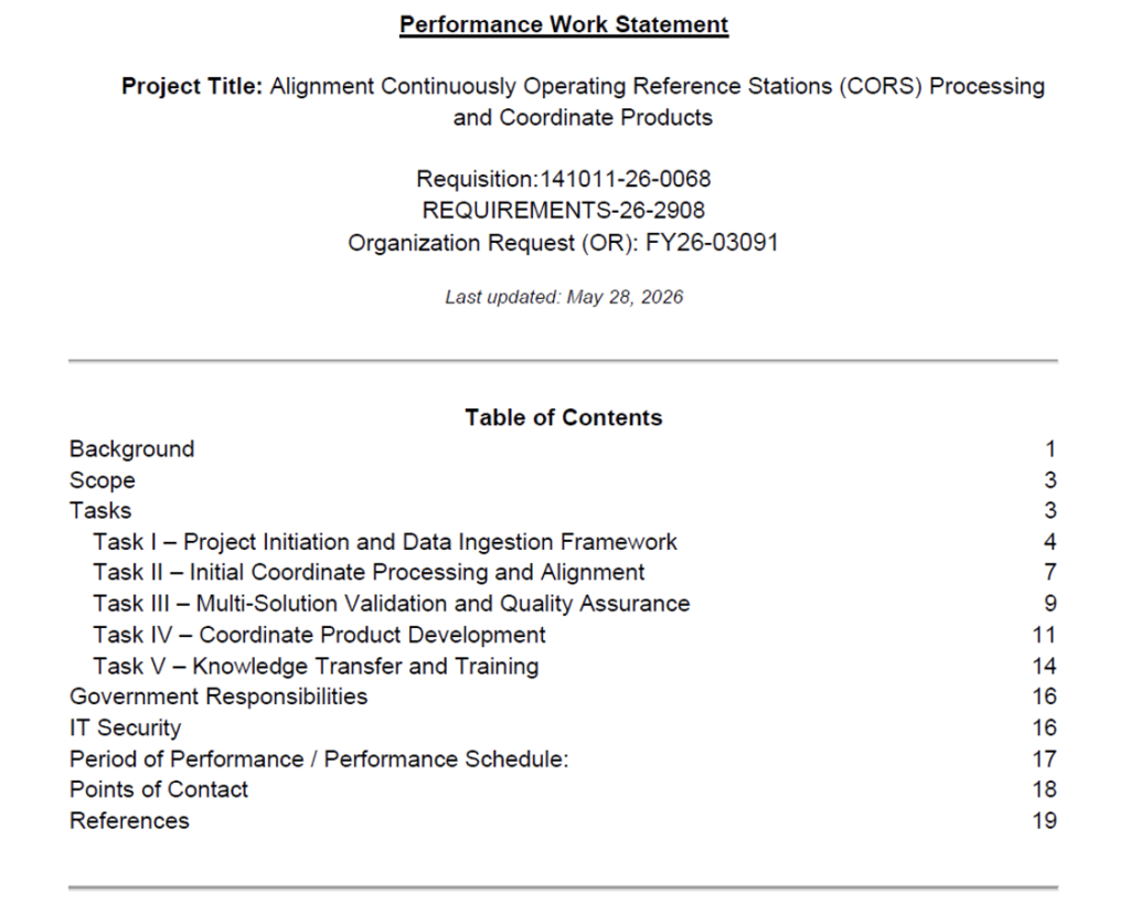
As mentioned earlier, NGS recently advertised a contract opportunity for NGS CORS Processing Development. The official project title is “Alignment Continuously Operating Reference Stations (CORS) Processing and Coordinate Products.”
In this newsletter, I will highlight the scope of the contract and discuss its implications for managers of CORS and Real-Time Network (RTN) systems.
The box titled “Table of Contents of the Performance Work Statement” provides an overview of the project.
Background Section Excerpts
The box titled “Excerpts for Background Section” provides the standard background information on the modernization of the NSRS and explains why this project is important to NSRS users.
I have highlighted the portions of the background section that are particularly relevant to RTN managers and users. The three statements below underscore that NGS recognizes the need to update coordinates at non-NOAA CORS stations. This will both facilitate the successful implementation of the new NSRS and provide a mechanism to support future expansion and updates of non-NOAA CORS.
- A significant operational gap currently exists for CORS stations that are not part of the NOAA CORS Network (NCN) or included within existing National Geodetic Survey (NGS) multi-year coordinate solutions. Many Real-Time Networks (RTNs), public agencies, universities, and private-sector positioning services depend on these non-NCN CORS stations to support GNSS operations and positioning services.
- To address this requirement, NGS seeks contractor support to develop and implement a scalable processing framework capable of generating coordinates for non-NCN CORS stations aligned to the International Terrestrial Reference Frame of 2020 (ITRF2020) at epoch 2020.0 and suitable for integration into the modernized NSRS.
- This effort will provide a scalable pathway for future expansion, episodic updates, and continued alignment of distributed GNSS infrastructure with the modernized NSRS.
Excerpts from Background Section
NGS is modernizing the NSRS through the development and release of new terrestrial reference frames and geopotential datums, including North American Terrestrial Reference Frame of 2022 (NATRF2022), Pacific Terrestrial Reference Frame of 2022 (PATRF2022), Caribbean Terrestrial Reference Frame of 2022 (CATRF2022), Mariana Terrestrial Reference Frame of 2022 (MATRF2022), and North American-Pacific Geopotential Datum of 2022 (NAPGD2022). These modernized reference frames are designed to improve positional accuracy, account for crustal motion and geophysical change over time, and support emerging geospatial and positioning technologies. The modernized NSRS will rely heavily on Global Navigation Satellite System (GNSS) infrastructure, including CORS, to provide direct access to authoritative positioning.
A significant operational gap currently exists for CORS stations that are not part of the NOAA CORS Network (NCN) or included within existing National Geodetic Survey (NGS) multi-year coordinate solutions. Many Real-Time Networks (RTNs), public agencies, universities, and private-sector positioning services depend on these non-NCN CORS stations to support GNSS operations and positioning services. Current operational tools provide limited capability for station managers to derive and maintain coordinates aligned with the modernized NSRS at a defined reference epoch in a scalable and repeatable manner. However, there is currently no simple and operationally scalable mechanism for generating and maintaining coordinates aligned to the modernized NSRS for these stations.
To address this requirement, NGS seeks contractor support to develop and implement a scalable processing framework capable of generating coordinates for non-NCN CORS stations aligned to the International Terrestrial Reference Frame of 2020 (ITRF2020) at epoch 2020.0 and suitable for integration into the modernized NSRS. The work will include ingestion and management of GNSS observation data and associated metadata, implementation of multiple independent processing approaches, validation and quality assurance procedures, coordinate combination methodologies, and development of operational coordinate products suitable for long-term maintenance and expansion.
The resulting products and workflows will support improved access to the modernized NSRS for RTN operators, government agencies, commercial providers, and the broader geospatial community. This effort will provide a scalable pathway for future expansion, episodic updates, and continued alignment of distributed GNSS infrastructure with the modernized NSRS. Coordinate products generated under this effort are intended to support NSRS modernization activities, validation, and operational alignment workflows and do not independently constitute official NSRS published coordinates unless adopted and published by NGS.
The document contains detailed information about the scope and tasks associated with the contract project. I have highlighted two statements that I believe are important to RTN managers and users.
- This project will develop a scalable and repeatable processing framework capable of generating NSRS-aligned coordinates for Geodetic Reference Points (GRPs) associated with CORS not currently included in existing NGS multi-year coordinate solutions
- The framework shall be designed to support scalable, repeatable, and maintainable future processing of additional stations and subsequent coordinate updates.
What does this mean for RTN managers and users?
These statements are significant because they indicate that, as new non-NOAA CORS are established (provided they adhere to NGS policies), a clear and defined process will be in place to generate NSRS-aligned coordinates — and to efficiently update those coordinates during future reference frame adjustments.
Why is this important to users?
Currently, non-NCN CORS stations do not automatically receive updated coordinates and velocities when NGS releases new realizations for the NCN CORS.
For example, NGS recently implemented the International Terrestrial Reference Frame 2020 (ITRF2020) and IGS20 realizations across the U.S. NOAA CORS Network (NCN). These updates applied only to NCN stations and not to non-NCN stations.
My August 2025 GPS World Survey Scene newsletter highlighted the Multi-Year CORS Solution 3 (MYCS 3), and my December 2025 newsletter covered the AAGS YouTube sessions, both stressing the importance of aligning Real-Time Networks (RTN) to the new modernized NSRS once it is officially adopted in 2027.
Excerpts for the Scope and Tasks Section
This project will develop a scalable and repeatable processing framework capable of generating NSRS-aligned coordinates for Geodetic Reference Points (GRPs) associated with CORS not currently included in existing NGS multi-year coordinate solutions. The resulting coordinate products shall support alignment with the modernized National Spatial Reference System (NSRS), including the new terrestrial reference frames associated with NATRF2022, PATRF2022, CATRF2022, and MATRF2022.
The contractor shall independently evaluate the consistency, stability, and suitability of coordinate solutions generated through multiple geodetic processing methodologies.
Processing activities include:
- Ingestion and management of GNSS observation data and associated metadata;
- Implementation of PPP and double-difference processing;
- Processing of observation windows near reference epoch 2020.0;
- Independent validation using additional observation windows and deformation modeling approaches, including IFDM2022;
- Comparison and validation against existing NCN and IGS coordinate products, where applicable;
- Coordinate combination and stacking methodologies;
- Development of repeatable workflows and supporting documentation; and
- Generation of coordinate products, including associated uncertainties and metadata.
The framework shall be designed to support scalable, repeatable, and maintainable future processing of additional stations and subsequent coordinate updates.
To support the management and execution of this effort, the work has been divided into the following tasks:
- Task I – Project Initiation and Data Ingestion Framework
- Task II – Initial Coordinate Processing and Alignment
- Task III – Multi-Solution Validation and Quality Assurance
- Task IV – Coordinate Product Development
- Task V – Knowledge Transfer and Training
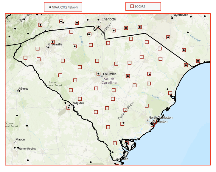
So, what does this specifically mean to some RTNs? Here are two examples that I’ve provided at recent seminars. The figure titled “Non-NOAA CORS in South Carolina” depicts the NCN stations and the non-NCN stations in South Carolina, and the figure titled “Non-NOAA CORS in Iowa” depicts the NCN stations and the non-NCN stations in Iowa.
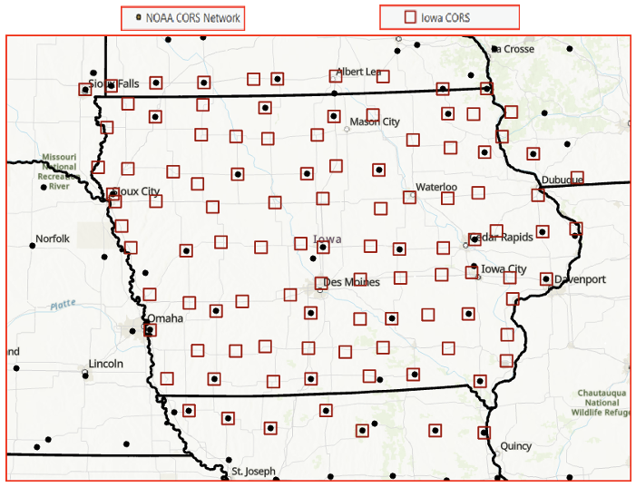
Implications for Non-NCN Stations
As the figures above illustrate, both states contain a large number of non-NCN stations. When NGS updated the NOAA CORS Network for MYCS 3, these non-NOAA CORS stations were not included. As a result, their coordinates became inconsistent with the surrounding NOAA CORS stations. Fortunately, this was not a major issue because the changes between MYCS 2 and MYCS 3 were relatively small.
However, as shown in the figure at the beginning of this newsletter titled “Approximate Differences Between NATRF2022 (Epoch 2020.0) and NAD 83 2011 (Epoch 2010.0) in NC,” the upcoming shift to the new reference frame will be significantly larger, exceeding 3 ft in many parts of North Carolina.
The proposed NGS contract project will deliver a reliable, consistent, and accurate method for aligning non-NCN CORS and RTNs with the modernized NSRS. This will greatly streamline implementation across the geospatial community. I want to emphasize once again that NGS is actively listening to user feedback.
Looking ahead, I hope NGS will pursue future initiatives to incorporate all non-NCN stations into the Intraframe Deformation Model (IFDM). Including these stations — particularly in areas with active crustal motion — would further improve the model’s reliability and accuracy.
Please share your feedback with NGS — they are listening.


NEIL HILL
The bummer – if I read that correctly is that the contract will initiate in Sept 2026. It will then run for a year and a half. I hope the state DOTs don’t wait that long to adjust their CORS, it will be 2028 at that rate.
HAROLD NELSON
Maine has 4 CORS out of 29, not in NCN. After MYCS3, I updated the 4 non-NCN stations to be consistent with the NCN stations, plus added 8 CAN-NET CORS from Canada all now in the Maine Real-Time Network. I recently got a ‘tweak’ on one of our CORS in Lincoln, Maine, adjusted by about a centimeter in Northing, and updated the value for that station. The rest seem fine, hoping won’t have to re-adjust until after the datum change. I should mention that due to a backlog at NGS, 2 of the 4 NCN stations ‘should’ reach NCN status, while two others don’t qualify. Stations that don’t qualify, I am told, that we can do some special observations of benchmarks around the stations and that will qualify for a NGS positional value, though not NCN. Those non-NCN stations would have their values adjusted by NGS when NGS updates the Realizations. It would be nice if we could do observations around the CAN-NET stations and have NGS put a positional value on them.
Dan Messerich
In Iowa there are 59 non-NCN stations. I blue booked those non-NCN stations a few years ago and they have a PID. Will NGS adjust all PID’s in the database?