No audio available for this content.
Hexagon’s Geospatial division has launched M.App Enterprise 2021, a significant update to its platform for creating geospatial and location intelligence applications. The latest release features new browser-based 3D capabilities and enhanced visual effects, plus the ability to create and configure custom applications more easily.
M.App Enterprise 2021 adds complete and seamless integration with Hexagon’s LuciadRIA. Now, users can access LuciadRIA’s 3D features, including support for panoramic imagery, shading, ambient occlusion and other visualization effects, to build browser-based solutions with no development necessary.
The latest version also features a new browser app configurator that makes it even easier to create spatio-temporal dashboards, known as Smart M.Apps. Additionally, Feature Analyzer has been expanded to allow users to add and manage multiple datasets on the fly and set up workflows. These enhancements enable more dynamic configurations, allowing field workers to be alerted quickly when action is required.
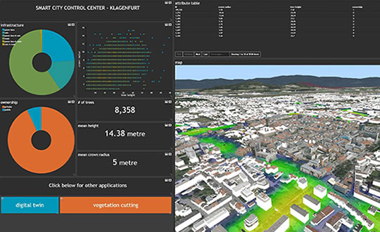
The city of Klagenfurt, Austria — a long-time Hexagon customer — has already begun using M.App Enterprise 2021 to create a city app platform that features a detailed 3D urban landscape of the entire city.
“This opens up endless possibilities for applications to automate several manual processes within different departments of the city,” said Günter Koren, head of the department of surveying and GIS at the city of Klagenfurt. “We believe M. App Enterprise will be an essential step in our journey to become a smarter, safer city for our 100,000 citizens.”
The latest release contains other new features and improvements, including an overhauled style editor, a new default dark theme, options for customized theming and full support for SAP HANA databases.
“M.App Enterprise 2021 helps organizations achieve smart monitoring of their cities, infrastructure and services by seamlessly incorporating location intelligence into enterprise systems and workflows,” said Georg Hammerer, chief technology officer of Hexagon’s Geospatial division. “With augmented visuals and dynamic configurations, this new version of M.App Enterprise can help customers easily set up powerful applications, allowing them to be more productive and efficient.”