No audio available for this content.
Eos will announce compatibility of its Arrow GNSS receivers with the inaugural ArcGIS Field Maps beta release, the expansion of Eos Locate underground mapping locator-device compatibility, as well more exciting updates for users of high-accuracy GPS with ArcGIS apps.
Eos Positioning Systems, manufacturer of the high-accuracy Arrow Series GNSS receivers for the GIS market, has announced several new releases ahead of the 2020 virtual Esri User Conference.
The announcements include the expansion of the availability of the Eos Locate
underground mapping solution, compatibility with the new ArcGIS Field Maps, the inaugural release of Eos Tools Pro for Windows, and a “special surprise” for virtual attendees of the 2020 Esri UC.
Expansion of Eos Locate
Eos Locate is a high-accuracy, real-time underground mapping solution for Esri
ArcGIS apps users. It allows organizations to accurately map already-buried assets straight to ArcGIS Online via either ArcGIS Collector or ArcGIS Field Maps.
Eos has expanded Eos Locate compatibility with additional models from Vivax-Metrotech, Subsite and Radiodetection.
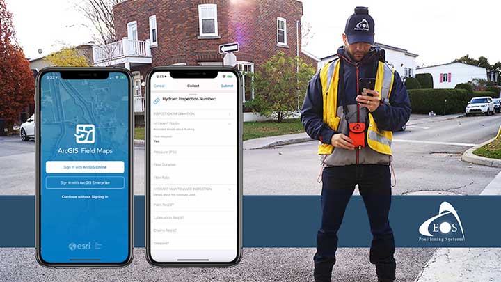
Compatibility with ArcGIS Field Maps beta
ArcGIS Field Maps is the newest Esri mobile application, which combines the functionality of several existing Esri mobile applications, such as ArcGIS Collector, ArcGIS Explorer, and ArcGIS Tracker.
The ArcGIS Field Maps beta release this month is already fully compatible with Arrow GNSS receivers (all models). This means organizations with Arrow GNSS receivers can immediately start taking advantage of survey-grade Arrow GNSS locations and metadata within ArcGIS Field Maps for data collection, markups, read-only routine field work (e.g., utility locates), GPS tracking, and more.
In addition, two Eos solutions previously exclusive only to Collector also already work with ArcGIS Field Maps. These include:
- Eos Locate for underground asset mapping
- Eos laser mapping (laser offsets) for collecting assets from afar
Inaugural release of Eos Tools Pro for Windows
Eos Tools Pro is a free GNSS monitoring application for Arrow GNSS receivers. For the first time, this app is now available for Windows 10 users.
Eos Tools Pro allows fieldworkers to:
- Connect to an RTK network or base station via NTRIP
- Get elevations in orthometric heights via geoid model conversions in real time, in the field (directly into an Esri app)
- Apply a simple X, Y, Z datum shift to the current location to match any local datum
- Set a vast number of audible alarms
In addition, developers using Windows 10 will now be able to access the wide array of Arrow GNSS metadata while eliminating the task of parsing NMEA data.
Finally, Eos Tools Pro features a built-in duo of virtual Com Port and TCP/IP server to output streams of standard NMEA sentences. This enables multiple apps to have simultaneous access to the Arrow GNSS location and metadata.
Special surprise for eligible 2020 Esri UC attendees
In support of the inaugural virtual Esri UC, Eos is offering a one-time-only chance to win an Arrow 100 submeter GNSS receiver. To enter to win, eligible attendees must both
- Complete a meeting with an authorized Eos representative during the 2020 Esri UC (July 13-16), which can be achieved by visiting the Eos virtual booth (V103), and
- Fill out a special contest contact form made available by that representative.
Both the meeting and special contest contact form submission must be completed no later than July 16.
The following people are not eligible to win: Employees of Eos and Eos distributors, employees of Esri and Esri distributors, employees of other exhibiting/sponsoring companies, employees of other GPS manufacturers or vendors, registered media, and others whom we deem to have a similar affiliation.
Visit the Eos virtual booth (V103) to talk with sales, marketing, and technical support staff during the event expo hours.


