No audio available for this content.
An interview with Chris Trevillian, director of product management, geospatial GNSS at Trimble about recent GNSS receiver innovations.

What was the most significant technical innovation in your GNSS receivers in the past five years?
In 2019, Trimble broke ground with Trimble ProPoint, the fifth generation high-precision positioning engine, engineered to provide position and orientation data from the fusion of GNSS signals, globally accessible high-accuracy correction services, and measurement data from a variety of sensors.
When Trimble launched ProPoint signal processing with the Trimble R12 GNSS receiver, head-to-head testing with the Trimble R10-2 in challenging GNSS environments (near canopy and built environment) showed the R12 performed 30% better across a variety of factors, including time to achieve survey precision levels, position accuracy and measurement reliability.
In September 2020, Trimble announced the Trimble R12i GNSS receiver. It incorporates tilt compensation based on an IMU using Trimble TIP technology, which enables points to be measured or staked out while the survey rod is tilted. This empowers land surveyors to focus on the job at hand and complete work faster and more accurately.
What has it enabled users to do that they could not do before?
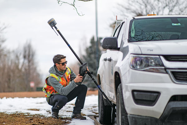
ProPoint provides new levels of reliability and productivity. In addition, the ProPoint engine is a key enabler of the new TIP technology.
The combination of ProPoint and TIP in the Trimble R12i allows users to accurately mark and measure points in areas previously inaccessible for GNSS rovers, such as building corners, or hazardous situations, such as the edge of an open excavation. The R12i also features real-time automatic inertial navigation system (INS) integrity monitoring. This system allows users to detect and correct for IMU biases introduced by use over time, temperature or physical shocks, helping ensure measurement quality and integrity for the life of the receiver. The combination of ProPoint and TIP technology improves accuracy, increases availability, provides better integrity and enhances constellation support.
Available on Trimble products utilizing Maxwell 7 technology, ProPoint leverages the latest developments in GNSS signal infrastructure and Trimble’s high-precision receiver hardware to deliver improved positioning performance in challenging environments. It also contains dynamic models of specific application movements, allowing it to filter out unexpected dynamic movements for improved accuracy.
What is a good example of this?
Benchmark Surveys, a small firm in Southwest England, wanted to test the R12i’s capabilities on a narrow road between an industrial park and Exeter Airport lined with high hedges, thick tangled foliage and large trees. The road-widening project, which required surveying 10 meters on either side of the road, would have been a challenge for any combination of surveying equipment. James Richards, Land, Utility and Measured Building Surveyor with Benchmark Surveys, told us the R12i was able to fix and gather points “in places not accessible by other GNSS kits we’ve used.” He said, “With the tilt compensation, we could reach under the edge of hedges and shrubs, up against buildings and walls, and safely out into the road.”


