No audio available for this content.
Tersus GNSS has updated its surveying smartphone app, Nuwa. The latest version includes features such as vector map import and digital surface stakeout.
The Nuwa app runs on Android and is reliable, and easy to operate. It has rich and powerful functions that can help surveyors complete measurements more efficiently and accurately.
The app is designed to work with the David and Oscar GNSS receivers from Tersus GNSS, plus other receivers that support NMEA-0183.
New features in Nuwa version 2.3.3.2 include:
- Vector map import and stake. The new version supports importing vector maps in DXF, LandXML, KML, and KMZ formats in the import module, optimizes the loading speed of vector maps for display in the Survey and Stakeout interface, and allows direct clicking to select points and lines on vector drawings for staking.
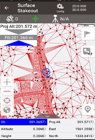
- Digital surface stakeout. The new version supports importing DXF files containing 3dface entities and LandXML files containing surfaces, manually selecting points to form Delaunay TIN, and entering surface offsets for fill and cut value interpolation calculations in Surface Stakeout.
- Update version description. Now, when receiving a version update, the highlights of the latest version are displayed directly in the application, including essential or market-focused features and fixes for issues.
Existing features of Nuwa include:
- Ability to configure base, rover and static surveys
- Graphical interface with background map (online/import)
- CAD stakeout, road stakeout and earthwork
- Data management (import/export multiple formats)
- Support for Bluetooth and USB connections
- Various built-in tools.
Download the latest version here.


