No audio available for this content.
SenseFly, provider of fixed-wing drones, has launched the eBee X for mapping.
The eBee X, part of the Parrot Business Solutions portfolio, is designed to boost the quality, efficiency and safety of an operator’s geospatial data collection.
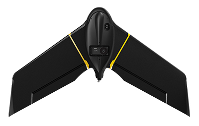
It offers a camera to suit every job, the accuracy and coverage capabilities to meet the requirements of demanding projects, and is durable enough to work virtually every site, the company said.
“The eBee X is a giant leap forward for mapping technology and underscores senseFly’s position as the leader in the fixed-wing drone market,” said Gilles Labossière, executive vice president and COO of Parrot Group and senseFly CEO. “No matter what type of project a professional is undertaking, the eBee X has the coverage, data and accuracy capabilities needed to get the job done.”
The eBee X includes a range of cameras for jobs ranging from land surveying and topographic mapping to urban planning, crop mapping, thermal mapping, environmental monitoring and more. Cameras include:
- The senseFly S.O.D.A. 3D: a unique drone photogrammetry camera with a one-inch sensor, which changes orientation during flight to capture three images (two oblique, one nadir) every time, instead of just one, for a much wider field of view. The result is stunning digital 3D reconstructions in vertically-focused environments—such as urban areas, open pit mines and coastlines—over larger areas than quadcopter drones can achieve. senseFly S.O.D.A. 3D is optimised for quick, robust image processing with Pix4Dmapper software.
- The senseFly Aeria X: a compact drone photogrammetry camera with APS-C sensor. This rugged innovation offers an ideal blend of size, weight and DSLR-like image quality. Thanks in part to its built-in Smart Exposure technology, it provides outstanding image detail and clarity, in virtually all light conditions, allowing operators to map for more hours per day than ever before.
- The senseFly Duet T: a dual-camera thermal mapping rig, which lets mapping professionals create geo-accurate thermal maps and digital surface models quickly and easily. The Duet T includes both a high-resolution (640 x 512 px) thermal infrared camera and a senseFly S.O.D.A. RGB camera with one-inch sensor. Both image sources can be accessed as required, while the rig’s built-in Camera Position Synchronisation feature works in sync with Pix4Dmapper photogrammetry software (optional) to simplify the map reconstruction process.
The eBee X is also compatible with the Parrot Sequoia+ multispectral camera for agriculture, the senseFly S.O.D.A. drone photogrammetry camera and senseFly Corridor for simple linear mapping.
The eBee X can meet the exacting requirements of every project. Its unique Endurance Extension option unlocks a flight time of up to 90 minutes (versus a maximum endurance of 59 minutes by default).
With this capability activated, the drone is able to achieve vast single-flight coverage of up to 500 hectares (1,235 acres) at 122 meters (400 feet), while the eBee X’s built-in High-Precision on Demand (RTK/PPK) function helps operators to achieve absolute accuracy of down to 3 centimeters (1.2 inch) — without ground control points.
According to senseFly, the eBee X allows users to work virtually every site, no matter how demanding, thanks to the drone’s built-in Steep Landing technology, ultra-robust design, live air traffic data and more, all backed by senseFly’s professional, localized support.
The eBee X is ideally suited to the varied and evolving needs of mapping professionals. These include: surveying and construction companies, quarry and mine operators, agronomists and forestry engineers, professional drone service providers, aerial imagery companies, environmental researchers and more, the company added.
The eBee X is supplied with senseFly’s eMotion flight planning and data management software.


