No audio available for this content.
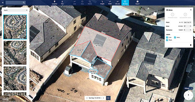
Nearmap has introduced a complete measurement toolset in MapBrowser for the solar, roofing and other rooftop industries.
The new tools allow users to measure roof-pitch, height, width and area, enabling roofers and solar installers to confidently measure rooftops and structures from high-resolution oblique aerial images, the company said.
The new MapBrowser helps customers significantly reduce onsite visits during the quoting and planning stages of projects and complements their remote roof/site inspection workflows, giving many small businesses the power of expensive systems that only large companies use.
“Gone are the days of climbing on roofs to take measurements,” said Tony Agresta, executive vice president of product at Nearmap. “Delivered to the cloud within days of capture, our aerial imagery allows roofers, solar companies and other small businesses to carry out assessments from the comfort of their office. Once the domain of large companies, the new features provide businesses of all shapes and sizes with the tools they need to save time, plan and estimate more accurately at a fraction of the price.”
Using Nearmap’s new tools, roofers and solar companies will be able to:
- Prospect more efficiently by viewing and expanding opportunities through aerial maps instead of other, more traditional ways.
- Process leads more quickly by qualifying prospects prior to visiting a potential job.
Reduce costs associated with the qualification and proposal stages. - Create better proposals using up-to-date, high-resolution photos, giving companies a better chance at winning a client’s business.
- Close more sales with the most accurate and competitive quotes.
Increase revenue without adding systems or headcount.
Businesses in construction, home building, painting, insurance and other industries can also benefit from these new tools to accurately measure areas on properties in three dimensions. Nearmap’s aerial imagery can help users to show context for work being done, and the imagery can be annotated with notes, drawings and measurements that provide details of the plan.
Nearmap Oblique imagery can be accessed through a standard web browser using Nearmap’s intuitive MapBrowser application. In addition, Nearmap Oblique photos are published at sub-7.5cm ground sampling distance (GSD) — better than satellite imagery — which allows users to see great detail, Nearmap said.