No audio available for this content.

Kaarta and Exploration Instruments have announced a collaboration and distribution agreement to address the needs of the unexploded ordnance (UXO) and geophysical industries.
Kaarta provides real-time mobile 3D reality capture, and Exploration Instruments LLC (EXI) has expertise in near-surface geophysical equipment and applications.
EXI now offers rental, sales, and training for Kaarta’s SLAM-based mobile mapping systems and the integration with geophysical equipment such as digital geophysical mapping (DGM) and advanced geophysical classification (AGC) sensors.
Contamination and munitions from former combat areas or military training grounds is a global hazard. In the U.S. alone, more than 5,400 sites covering millions of acres have been identified for investigation and environmental restoration according to the U.S. Army Corps of Engineers.
The general remediation approach pinpoints buried ordnance location using electromagnetic and magnetic detection systems with GNSS positioning technology. While these systems perform well in open areas, other common environments such as steep terrain and wooded areas under tree canopy are challenging to find and remediate UXO.
The most common method for achieving required positional accuracy for DGM or AGC in wooded terrain is the use of robotic total stations (RTS) to tie surveyed locations to detection systems. However, RTS line-of-sight requirements make mapping and classification difficult and time-consuming, resulting in slower production rates and increased effort as data-collection teams must revisit common data gaps in the RTS coverage to achieve 100% coverage of the mappable areas.
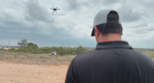
Kaarta’s simultaneous location and mapping (SLAM) solution provides accurate global positions within several centimeters in these demanding environments. Kaarta Stencil 2-16 mobile mapping system combines lidar, an inertial measurement unit (IMU) and visual odometry measurements to build a 3D map of the environment while updating global position data in real-time when moving through the map, without the need for external signals such as GNSS.
The U.S. Army Corps of Engineers tested Kaarta’s Stencil 2-16 to provide rapid positioning data in GNSS-denied areas and found it provides positional data with the required accuracy for DGM and AGC at military munitions response sites.
Kaarta systems are successfully integrated and used with a range of geophysical equipment including Geometrics MetalMapper 2×2, Geonics EM-61, and White River Technology’s APEX systems. EXI ties it together by providing geophysical expertise, training and access to the latest equipment through both rental and sales. Stencil 2-16 integration with other sensors is easy using customizable GNSS NMEA strings and supports a wide range of RS-232, USB and Ethernet interfaces.
“It’s exciting when a combination of technologies come together to address such a significant problem as locating UXO in the most challenging of environments,” said Dave Duggins, UXO applications specialist at Kaarta. “We’ve been out in the woods with customers and are thrilled with the results we’ve achieved which include increased production rates with fewer personnel. Partnering with EXI to bring this solution to market is a perfect match.”
“There are hundreds of thousands of wooded acres that still need to be remediated,” said Dennis Mills, EXI’s President, “Providing geophysicists with a proven integrated solution that significantly improves productivity over current methods is a win all around.”
Kaarta systems can also be integrated with other sensors that use GNSS for positioning – ground penetrating radar, magnetometers, terrain conductivity meters — for a wide range of applications where positioning is needed in GNSS-denied areas. Kaarta was recently issued a patent covering its novel approach to fuse data captured by SLAM systems with data from other sensors to measure and localize sensed data in the scanned environment.
EXI will be the primary provider of Stencil 2 rentals, sales, and training to the UXO and geophysical industry.