No audio available for this content.
New sensing and software tech spurs growth
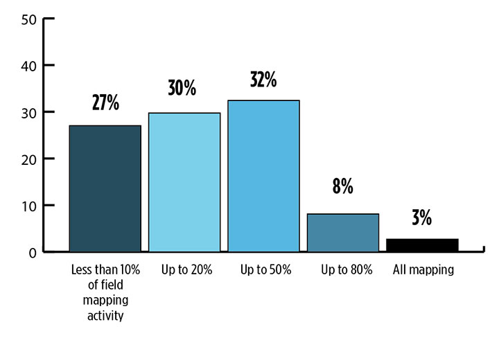
While UAVs are an exciting new technology for mapping, most respondents to our survey recognize the continued value of hands-on, in-the-field data collection.
 Most respondents think UAVs could be used for as much as half of data collection, but very few expect UAVs to be used for more than that. UAVs are just one mobile collection method, of course. Others include autos such as SUVs, boats and all-terrain vehicles.
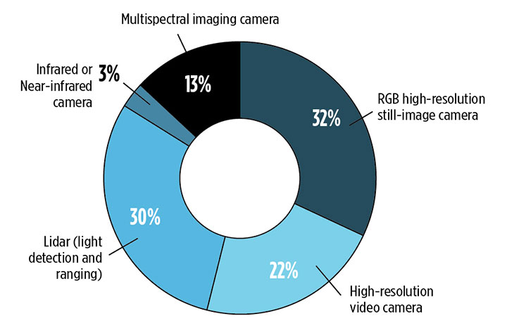
We also asked respondents how they use UAVs for data collection. RGB high-resolution still-image cameras and lidar are the most frequently used, with video cameras not far behind. Other specialty cameras collect infrared or thermal imagery, while specialty sensors collect everything from temperature to pressure and methane levels.
Whether mounted on a UAV, a vehicle, or on the ground, these technologies are used in fields as diverse as forest management, disaster response and infrastructure planning.
For instance, urban planners rely on mapping data for land value, topography and water and electricity resources. Meanwhile, forestry experts use infrared to detect areas of disease or die-off in the early stages.
Software in the Cloud. Turning to software, developments in cloud storage and open-source and subscription platforms are constantly improving geographic information systems (GIS). A wealth of GIS and GPS data is available from Google Maps, Apple Maps, OpenStreetMap and other applications. Specialty applications include Esri ArcGIS, Maptitude, Surfer and more. In the coming years, expect an increase in 3D modeling, digital elevation models (DEMs) and augmented reality.
The automotive sector has been adopting digital mapping applications for use in self-driving cars, as well as fleet management, logistics control systems, and advanced driver assistance systems (ADAS).
Every year, more satellites are launched for mapping and GIS data collection, and they don’t all provide photo imagery. For instance, NASA’s Aqua satellite detected and mapped huge concentrations of carbon monoxide drifting east across the U.S. from western wildfires — important information for public health planning.
For more results from the 2018 State of the GNSS Industry, see this page.


