No audio available for this content.
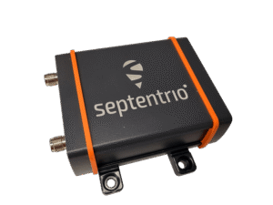
The Government of Nepal has completed fieldwork for measuring Everest’s height using GNSS equipment from Trimble, including the robust R10 receiver.
The Survey Department of the Government of Nepal has completed fieldwork for the National Initiative for the Measurement of the Height of Sagarmatha (Mount Everest). The Nepali survey team summited at 3 (local time) May 22, 2019 (by the Nepali calendar, that’s २०७६ जेठ ८, or June 8, 2076).
The summit team of Chief Survey Officer Khim Lal Gautam and Survey Officer Rabin Karki was supported by mountain guide Tshiring Jangbu and two of his fellow Sherpas.
The ascent was dark, windy and treacherous — the team had to make optimal use of the limited time that the hazardous conditions and their oxygen supplies afforded. The primary surveying task was to collect GNSS observations with the Trimble R10 GNSS receiver they carried.

Due to the limited time window on the summit, they had essentially one shot at the GNSS observations. The R10 was configured to begin collecting observations on power-up. During training and test observations before the ascent, the R10 had proven to be exceptionally reliable, with no malfunctions.
Compact size, light weight and durability were important factors for the receiver chosen for the summit observations. The IP67-rated R10 with internal battery weighs 1.12 kg (2.5 lb.) and operates in a temperature range of –40° C to +65° C (–40°F to +149° F). Its solid alloy housing withstands a 1-meter drop. The only concern for the team on the final ascent was to keep the battery and spares warm.
The R10 recorded 1 hour and 16 minutes of GNSS observations. The static data (observations from GPS, GLONASS, Galileo and BeiDou) was post-processed using Trimble Business Center software together with observations from eight GNSS reference stations established as an active control network for the survey. Several of the reference stations were Trimble NetR9 network receivers with Zephyr Geodetic antennas.
The team also used a compact ground penetrating radar (GPR) instrument to determine the distance between the top of the ice/snow cap on the summit and the highest point of solid rock beneath.
Many of the successive accepted heights for Everest have been to the top of the ice cap, which can vary seasonally by several meters. A goal of the survey is to provide heights for both aspects of the peak. An additional reason to establish a new height for Everest is to determine whether, and by how much, the 2015 earthquakes in the region altered the mountain.

While the Nepalese survey team’s GNSS observations on the summit will yield the height, the final orthometric elevation will be achieved by applying an updated gravity model. The gravity model was refined from supporting surveys on the mountain and surrounding region.
A total of 298 new gravity observations were performed over several years, with companion GNSS observations on each control point. More than 248 kilometers of precise leveling, supplemented with trigonometric leveling, was performed for the network of control and base receiver locations. Instruments employed for these terrestrial surveys included Trimble DiNi levels and S9 total stations.
Trimble GPS/GNSS instruments have been to the Sagarmatha summit on multiple occasions, including in 1990, 1998, 2005 and 2012. The R10 represents the lightest and most compact of these to date.
By prior agreement between Nepal and China, the results of the 2019 Nepali survey, and a May 2020 Chinese survey, will be jointly announced. Official results are expected this summer.
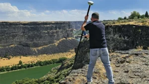
Featured photo: A GNSS reference station network was established before the survey to provide data for post processing, and to support additional surveying and geophysical studies of the region. (Photo: Trimble)