No audio available for this content.
Eos Positioning Systems — manufacturer of Arrow Series GNSS receivers — has released Eos Tools Pro for Windows 10.
Eos Tools Pro implements powerful new features that enables users to exploit all four global GNSS constellations and a state-of-the-art NTRIP client to access real-time kinematic (RTK) bases and RTK networks all over the world via NTRIP, Direct IP and wireless radios.
“This is a huge step forward in functionality and flexibility for our Windows users,” said Jean-Yves Lauture, CTO of Eos. “We implemented the latest support for Windows Geolocation and other features offered by Microsoft in order to allow our customers to use high-accuracy locations directly into their apps.”
Eos Tools Pro includes new features for both field professionals and application developers.
For field professionals
RTK network/RTK base connectivity. Eos Tools Pro implements state-of-the-art NTRIP connectivity to connect to any RTK network or RTK base in the world. For geographic areas without cellular coverage, Eos Tools Pro supports Bluetooth wireless radios (UHF/VHF, etc.) for base/rover connectivity.
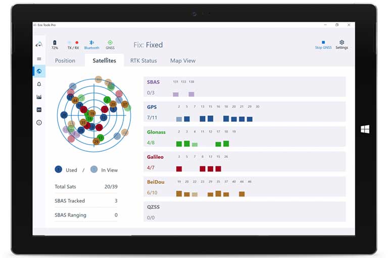
The software supports all new BeiDou and Galileo satellites in addition to GPS and GLONASS as well as SafeRTK functionality for areas with marginal cellular coverage.
Geoid models. Eos Tools Pro implements the latest geoid models for many regions in the world, providing survey-grade orthometric heights directly into any Windows applications.
Datum shift. Eos Tools Pro adds a new feature to apply a simple X, Y, Z shift to the current location to match any local datum.
Alarms. A vast number of audible alarms can be set to warn the user if parameters such as estimated accuracy, differential status, correction age, Bluetooth connectivity, are not met.
For Windows developers
Geolocation/Sensor API. Eos Tools Pro supports apps that rely on the Windows geolocation service to retrieve accurate latitude, longitude and altitude from their Arrow receiver. In addition, the Sensor API allows programmers to access the wide array of GNSS metadata while removing the laborious task of parsing NMEA data.
Virtual COM port and TCP/IP server. Eos Tools Pro features a built-in duo of virtual COM port and TCP/IP server to output streams of standard NMEA sentences. This enables multiple apps capable of parsing NMEA messages to have simultaneous access to the Arrow GNSS location and metadata.
“Eos Tools Pro for Windows enables users and developers to benefit from our leading-edge, high-accuracy GNSS receivers,” Lauture said. “When Windows tablets are the device of choice among our customers, the combination of Eos Tools Pro and Arrow GNSS receivers provide the absolute latest GNSS technology for GIS, engineering, construction, and surveying users. When Windows tablets are the device of choice among our customers, the combination of Eos Tools Pro and Arrow GNSS receivers provide the absolute latest GNSS technology for GIS, engineering, construction and surveying users.”
Eos Tools Pro for Windows is available for free to users of Arrow GPS and GNSS receivers. It is compatible with any Windows 10 desktop, laptop or tablet computer via Bluetooth or USB.


