No audio available for this content.
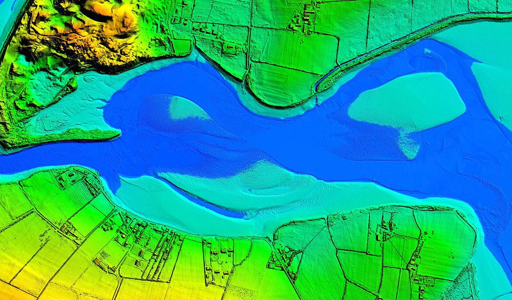
Bluesky International will use aircraft-mounted lidar sensors and laser scanners to create a highly detailed 3D map of the whole of the Northern Ireland coastline.
Working on behalf of the Department of Agriculture, Environment and Rural Affairs (DAERA), the lidar survey will be used to create the first complete baseline. The baseline will underpin recording of coastal change and help identify the rate at which the coastline is changing as a result of climate change.
In addition to the lidar data Bluesky will simultaneously capture high detailed aerial photography which will be processed to produce to a fully orthorectified, 10-centimeter-resolution database.
The Bluesky data will form part of the wider Northern Ireland 3-dimensional coastal survey. The survey will extending into the marine environment with a satellite-derived bathymetric survey and a pilot bathymetric lidar survey. Together, the surveys will inform the development of future coastal management policies.
“The Northern Ireland coast is a hugely valuable resource which is currently facing increasing pressure from climate change,” said Joanne Hanna, senior scientific officer within the Marine and Fisheries Division of DAERA. “Sea-level rise, in combination with an increase in extreme storm events, is resulting in greater energy impacting our coastlines, altering coastal processes and accelerating change.
“Despite the importance and the value of this coastline, the nature and scale of the issues arising from coastal change and sea-level rise are currently not known and there is limited and insufficient baseline data available,” Hanna said. “The coastal lidar survey carried out by Bluesky will provide scientifically robust baseline data which will enable decision makers and coastal managers to make informed decisions and devise solutions and appropriate management to the problems currently facing our coastline.”
Bluesky will undertake the specialist survey using a fixed wing manned aircraft and will fly the 763 kilometres of Northern Ireland coastline capturing height measurements of both the underlying terrain and any surface features at a resolution of better than 16 points per metre. This data will be used to create highly accurate 3D digital terrain and surface models (DTM, DSM) with a spacing of up 25 centimetres.
The Bluesky datasets will be supplied ready for use in a range of geographical information system (GIS), desktop mapping and other specialist software packages and will be compatible with other DAERA datasets including Ordnance Survey mapping.