No audio available for this content.
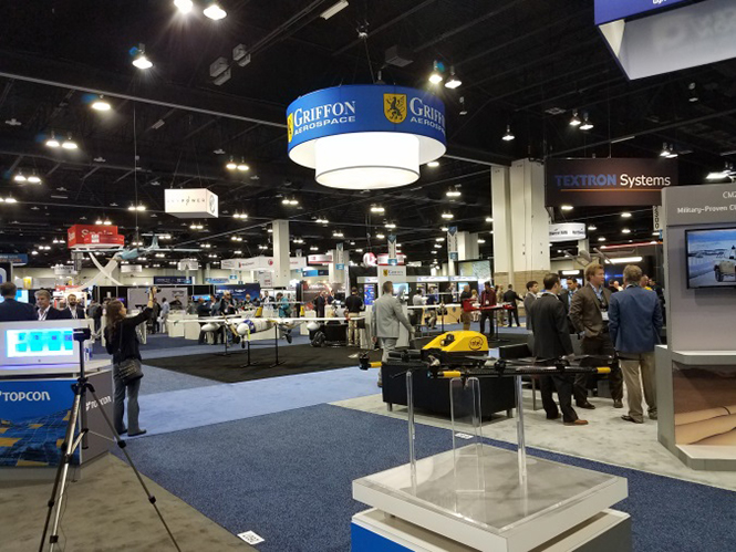
The Association for Unmanned Vehicle Systems International’s (AUVSI’s) Xponential 2018 show took place in Denver April 30-May 3. The event convenes the global community of commercial and defense leaders in intelligent robotics, drones and unmanned systems.
AUVSI Xponential was a big show once again — 8,500 attendees, more than 600 exhibitors, 200 educational sessions and 400 speakers. The show floor was huge as usual, with virtually every kind of UAS product and service imaginable for inspection at small, large and larger booths or display areas.
The morning kick-off presentation on Tuesday was enthusiastic about the coming large-scale adoption of drones and associated robotic technology, with a couple of real-time examples — driverless vehicles at Babcock Ranch in Florida and drone supply deliveries for humanitarian aid in Rwanda.
However, there still remain a number of barriers to wide-scale integration of drones into daily life from a regulation perspective, as Steven Bradbury, general counsel of the U.S. Department of Transportation, pointed out — while at the same time also indicating that the Federal Aviation Administration (FAA) has granted hundreds of waivers where the safety case has been adequate for lots of commercial UAS operations.
Most of the major GNSS players were exhibiting at the show, so we focused on gathering their news while also collecting a flavor of the many drone system suppliers in attendance.
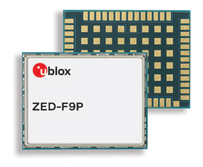 U-blox introduced its new ZED-F9P multi-band, multi-constellation chip — with GPS, GLONASS, Galileo and BeiDou signal reception and processing and on-chip multi-band RTK with fast convergence times — promising centimeter-level accuracy and low 85 mA (4x GNSS) power consumption in a 17 mm x 22 mm package.
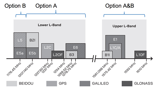
Initial urban testing in Finland in challenging conditions has indicated RTK performance at 9 cm 94%, with high availability, short convergence times (<10 seconds) and fast reconvergence. This kind of performance is apparently initially targeted at automotive applications — u-blox is a member of the Sapcorda automotive group — and is forecasting samples for this July, with production beginning before the end of this year.
The NovAtel tagline for the show was “Assured PNT,” which matches many U.S. and International agency objectives — this was accompanied by several announcements for both commercial and government agency products and applications.

For UAV and other commercial applications, NovAtel has introduced several small-sized OEM7 based products, including the PwrPak7D (GNSS only) and PwrPak7DE1 (GNSS + Epson G320N MEMS IMU) — both dual-antenna heading capable, multi-frequency packages.
The integrated E1 package includes NovAtel’s SPAN technology, which optimizes positioning and attitude performance during extended GNSS outages. Both new PwrPak enclosures come with the Interference Toolkit advanced interference detection and mitigation capability.
With most UAVs, the electronics on the airframe can produce a disruptive internal interference environment, and can lead to potential problems for the integration of sensitive GNSS. To help overcome this issue, NovAtel has released the OEM7600 receiver board in an extremely small form factor, enclosed with protective shielding to reduce the effects of emissions from nearby electronics.
The 7600 comes with 555 channels, multi-frequency/constellation positioning; L-band support for TerraStar corrections; serial, USB, CAN and Ethernet interfaces; advanced interference detection and mitigation features; RTK; GLIDE and Steadyline firmware options with 20-g vibration rating and the option to add integrated SPAN GNSS + inertial.
NovAtel also announced Inertial Explorer Express, which provides the same core processing and utilities as Waypoint Inertial Explorer software for applications including unmanned aerial vehicles (UAVs) and smaller projects. Inertial Explorer Express will produce centimeter-level position and attitude solutions for lidar, camera and other sensor data with faster processing times and reduced complexity.
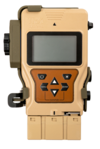
On the government/agency business side of the house, NovAtel has been quite successful with the GAJT antenna, which includes integrated anti-jam technology. GAJT is in use operationally and has been shipped to 16 allied nations around the globe, with the latest success being with the artillery Observation Post Vehicles (OPV) for the Canadian Army.


Canadian OPVs are used on the front-line of combat, so its essential that their location and timing information should not be compromised by enemy jammers. The NovAtel GAJT is readily retrofitted to existing vehicles to provide the necessary jamming defense needed by front-line forces.
Previously, NovAtel also announced the selection of GAJT for the UK fleet of Type 26 Frigates – providing essential anti-jam protection for its onboard navigation system.

Chris Wheeler and Omar Subra were good hosts when we visited them at the Trimble booth — Chris first made a YouTube video for GPS World (see below) and then gave me some insights into what’s new.
Basically, the OEM line has rolled over new versions of almost all individual receiver boards, with the addition of the BeiDou B3 frequency, capability for RTX PPP (precise point positioning) corrections, the addition of new constellations and inertial integration options.
An updated MB-Two receiver module can be configured for single frequency GPS through to dual frequency GPS, GLONASS, QZSS, Galileo and Beidou, uses RTX PPP and has an improved RTK engine for cm positioning from a base-station, or from over-the-air RTK corrections, or provides relative RTK against a moving base.
A typical Trimble application could include capturing an Insitu ScanEagle UAV in a difficult shipboard multipath environment with integrated GNSS-inertial, UAV navigation and control, UAV payload stabilization, or providing a “truth-system” for autonomous unmanned ground vehicles.
Since last year when Trimble introduced a “cell-phone” software receiver application, one useful application could have involved an insurance company using a “pocket-carried” antenna (with integrated RF) for field incident assessments. The cell-phone software license would be transferable to other assessors in the department, while a few pocket antennas are available for the whole assessment crew. This saves purchasing a whole load of hardware, and being limited to where the functionality can be moved or deployed. Everyone has a cell phone, and the relatively inexpensive antenna/RF can be available to all needing them.
Trimble is also ramping up its OEM customer service and repair capabilities to improve turn around for multiple customers and applications in the field. Improved results are beginning to help customers and its OEM business, while increased R&D investment is expected to put new products into the field in the fall.
This year Intel’s emphasis continued to be on how to manage the huge amount of data that high-precision visual and multi-spectral cameras are gathering by UAVs carrying out asset inspections for their customers. The Intel view is that this data is useless to an end-user unless it is interpreted and presented in a format that can be readily understood and used for the purpose it was intended.
Let’s say a company operates 75 drones inspecting installations it owns or operates across several states, and that 50 GB of data is the nominal amount of data each drone collects on each mission. That means that nearly 4 TB of data could be collected daily if all 75 drones operate at once. More likely, over 1 TB daily shows up in a central location — a huge amount of unprocessed data.
In a live demonstration, Intel showed how a typical installation inspection — by a drone taking high-resolution still photos at a remote location – could be collected and managed. Once in an Intel processing environment, the data quickly became visual format in 2D or 3D, and could be accessed remotely by an inspection team, saving significant travel costs and time to actionable results.
Intel also promised to soon exceed its record at the Pyeongchang Winter Olympics for the number of drones flown at once — currently set at 1,218 drones. The company’s next target is for a light display using 1,500 multi-colored drones.

Insitu held a media event at the show to announce its ScanEagle-3 drone system. Esina Alic, the new Insitu CEO, led a team who introduced and then unveiled the new commercial-standard ScanEagle variant.
This new variant has grown out of 20 years of experience and 15 years of working with the FAA to enable integration of drones into the U.S. National Airspace System (NAS). The ScanEagle-3 (SE-3) has been rebuilt with the objective of developing a certifiable vehicle with increased payload and endurance capability that is free of any ITAR restrictions — allowing export without restrictions to the rest of the world.
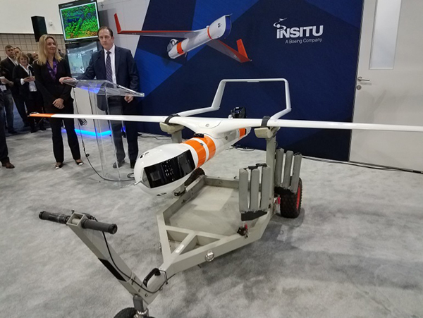
SE-3 features include:
- Significantly increased (x2) payload
- Still provides for full integration of all existing payloads
- Commercial, non-ITAR product for the global market
- Long-endurance platform
- Service contracts available
- Product release in Q2 2019
- Fully compatible with existing launch and recovery systems
- Around ~100 lb without payloads
ScanEagle variants were used in emergency response to the California wildfires at Santa Rosa and Medicina, gathering real-time information for fire-line combatants.
ScanEagle helped fight these wildfires using High Accuracy Photogrammetry (HAP) sensors. Military-grade electro-optical (EO) cameras during daylight and infrared (IR) cameras for night-time imaging extended the time available for tracking fire lines. Penetrating smoke or darkness, these UAVs gathered video and still images that were used to create geo-referenced, high-resolution digital fire progression and suppression maps to guide firefighting on the ground.

Summary
This small overview of Xponential 2018 attempts to provide a flavor of the breadth of activity we saw at the show last week. A good portion of this has also been captured through short videos published on the GPS World website, along with news articles.
There is more to come, with a report to follow from the show on Septentrio’s new product releases, Spirent’s GNSS simulation demo, DJI’s overview of drone products featured at the show, CyPhy Works tethered drones, Swift’s announcement of its Skylark correction service trials, Hemisphere’s new Vector Smart Heading Antenna, and Harxon’s antennas for drones.
A big show to cover, that’s for sure! It’s a good sign that people were perhaps talking more business than in previous years and a sign that the UAS industry is perhaps moving into its next growth phase.