No audio available for this content.
The Hawaiian Volcano Observatory (HVO) of the U.S. Geological Survey has been working to rebuild its geodesic monitoring network after lava consumed several GNSS stations in 2018.
The work began following the 2018 Kīlauea lower East Rift Zone eruption and summit collapse, with funding from the Additional Supplemental Appropriations for Disaster Relief Act of 2019 (H.R. 2157).
Teams are rebuilding and improving HVO’s geodetic monitoring network to better detect, assess and respond to volcanic hazards related to Hawaiian volcanoes. The main geodetic datasets used by HVO scientists to measure surface deformation (ground movements) are GNSS, tilt and satellite radar (InSAR) imagery.
HVO’s geodetic network includes more than 70 GNSS stations and 15 tiltmeters on the Island of Hawai’i that continuously record and transmit data. These instruments require routine maintenance, must be upgraded periodically due to age, and must be replaced if destroyed by volcanic activity such as in 2018.
Network upgrades include replacing out-of-date instruments and improving HVO’s network of near real-time monitoring instruments at critical areas on Kīlauea’s summit and rift zones to support early detection of magma movement and associated hazards.
Lava takes out stations
In 2018, lava flows destroyed three GNSS stations in the lower East Rift Zone. Another three GNSS stations were destroyed in the caldera collapses at Kīlauea’s summit.
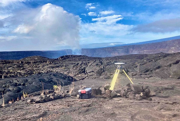
HVO staff rapidly deployed new GNSS stations at nearby locations to allow for continued monitoring during the eruption. These rapidly deployed sites included GNSS smart antennas mounted on surveys tripods — a setup typically only used for temporary deployments of several days to weeks.
Many of these rapidly deployed sites were decommissioned and removed after 2018. However, 13 of them are still being used for critical monitoring and remain on temporary tripods. These sites will be upgraded and hardened using engineered fixed monuments and masts. New sites will also be installed to replace sites destroyed in 2018.
Emergency monitoring ongoing
GNSS receivers acquired by supplemental funds already have supported emergency monitoring of active eruptions and other volcano-related activity. Data from these instruments help HVO detect volcanic activity and inform partners at Hawai’i Volcanoes National Park (HAVO), Hawai’i County Civil Defense (HCCD) and Hawai’i Emergency Management Agency (HI EMA).
For example, HVO rapidly deployed three new semi-continuous GNSS stations in response to the December 2020 Kīlauea eruption. These stations gave scientists a more complete view of magma returning to Kīlauea’s summit.
Similarly, HVO deployed rapid-response GNSS equipment at two pre-existing benchmarks during the Kīlauea south caldera intrusion event in August 2021, allowing scientists to track the migration of magma from the south caldera to farther south. New instruments give HVO a more detailed understanding of and ability to monitor Kīlauea’s volcanic processes.
HVO’s geodesy program plays a critical role in monitoring Hawaiian volcanoes. HVO’s updated geodetic network ensures that scientists can monitor changes in the shape of volcanoes, respond to eruptions, and understand magma storage and movement underground.
“Thanks to supplemental funding, HVO is in the best position ever to leverage our state-of-the-art geodetic network to gain insights into the active volcanoes in Hawai’i, assess their hazards, issue warnings, and advance scientific understanding to reduce the impacts of volcanic eruptions,” stated Volcano Watch, HVO’s weekly newsletter.