Listen to this content
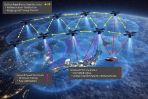
PlanetiQ has been awarded a $15 million, 48-month Strategic Funding Increase (STRATFI) contract by the U.S. Air Force. The program will support the development and launch of spacecraft equipped with next-generation GNSS radio occultation (GNSS-RO) and GNSS polarimetric radio occultation (GNSS-PRO) instruments and the delivery of high-value weather data to the U.S. Air Force.
The mission will focus on advancing GNSS-RO, GNSS-PRO and GNSS reflectometry (GNSS-R) capabilities. The program includes the development of advanced data assimilation techniques to integrate enhanced GNSS-PRO data into numerical weather prediction (NWP) models, improving forecast accuracy and enabling new insights into atmospheric conditions.
After spacecraft commissioning, PlanetiQ will provide on-orbit data delivery during the contract period. This will support multiple applications across the Department of the Air Force, including artificial intelligence (AI) model training, data assimilation, and performance evaluation.
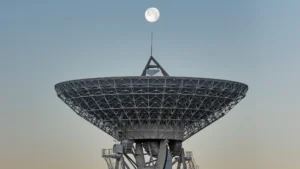
As the largest commercial provider of GNSS-RO data, PlanetiQ operates a global constellation of satellites, including spacecraft equipped with advanced receivers capable of capturing high signal-to-noise ratio (SNR) GNSS-RO and GNSS-PRO measurements. GNSS-PRO has demonstrated strong efficacy for measuring precipitation, a key capability for improving severe weather forecasting.
This STRATFI award will enable the development of a next-generation receiver that adds GNSS-R capabilities, supporting new applications such as ocean surface wind measurement, sea state characterization, and soil moisture monitoring over land.
“This award represents a major step forward in delivering more advanced, actionable weather information to the warfighter,” said Ira Scharf, CEO of PlanetiQ. “By combining GNSS-RO, PRO and R measurements in a single platform, we are unlocking a more complete picture of the atmosphere and Earth’s surface. We are proud to partner with the U.S. Air Force to accelerate these capabilities and bring next-generation environmental data into operational use.”