No audio available for this content.
Atmospheric and Environmental Research Inc. (AER), a Verisk business, will license a satellite-data-processing system from the University Corporation for Atmospheric Research (UCAR), building on UCAR’s commitment to improve weather forecasting.
The agreement will enable AER to process satellite data for commercial companies that sell their Earth observation data products to government agencies and other organizations that provide customized environmental information to a range of clients.
Under the agreement, AER will adapt UCAR’s SatDAACâ software system to process observations from satellites using GNSS radio occultation to observe the atmosphere. Those observations can lead to significantly improved weather forecasts.
From basic research to industry
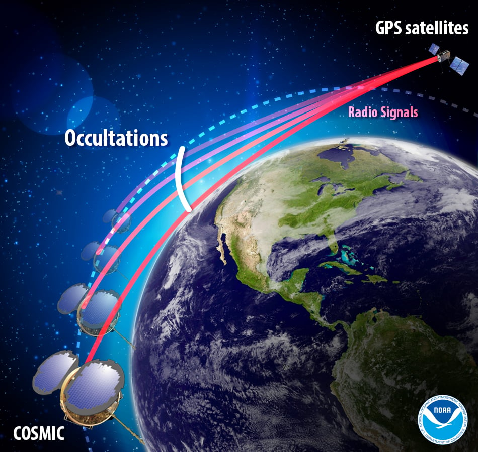
GNSS radio occultation measures the extent to which the radio signals from GNSS transmitter satellites (including GPS satellites) bend as they propagate through denser regions of the atmosphere.
The measurements can be further processed into information about temperature, pressure, and humidity in the lower atmosphere as well as the electron density in the ionosphere. The technique provides considerable accurate knowledge about a large volume of the atmosphere from near-Earth orbit down to the surface.
NASA’s Jet Propulsion Laboratory was first to use radio occultation to profile the atmospheres of Mars, Venus, and the outer planets starting in the 1960s. UCAR, in collaboration with JPL, pioneered the GNSS radio occultation observing technique for Earth’s atmosphere, building on basic research with funding from the National Science Foundation.
In 2006, UCAR began producing the first operational GNSS radio occultation data from a specialized constellation of small satellites known as the Constellation Observing System for Meteorology, Ionosphere, and Climate (COSMIC). The observations from COSMIC led to improved predictions of tropical cyclones and other storms as well as information about space weather and global climate.
A second constellation of small satellites, known as COSMIC-2, was launched in June 2019. It will provide twice as many soundings of the atmosphere with higher quality than COSMIC.
More GNSS-RO satellites coming
Now that the technology has been successfully demonstrated, additional satellites with GNSS radio occultation technology are being launched.
“This technology has moved quickly from being a research concept to providing vital information to forecasters,” said Ying-Hwa “Bill” Kuo. “The original investment in basic research is generating substantial benefits for society.”
Lead GNSS radio occultation researcher at AER Stephen Leroy said, “Earth radio occultation has a nearly 30-year history and has been a revolutionary force in numerical weather prediction and climate science in that time; and now with the commercialization of RO [radio occultation] data, we are looking forward to an explosion in RO data volume. I am really excited that we are performing the operational processing of this new data stream and expanding its scope and utility.”
The UCAR-AER agreement will likely lead to further advances in GNSS radio occultation technology, according to Bill Schreiner, director of the UCAR COSMIC Program.
“By transferring technology to the private sector, AER can take it to the next level in terms of distributing the data and finding new applications that help society,” he said. “This agreement will leverage SatDAAC’s advanced capabilities to develop new products for use by the environmental observing and prediction communities and will help us continue to innovate.”
At least three commercial enterprises are currently developing and deploying nanosatellites and microsatellites that perform GNSS radio occultation — Spire, GeoOptics and PlanetiQ — as well as several international space agencies.
AER works with governments and businesses worldwide to advance understanding of climate- and weather-related risks. The company develops analytical tools to help measure and observe the properties of the environment and translate those measurements into actionable information.
UCAR is a nonprofit consortium of 120 colleges and universities focused on research and training in the atmospheric and related sciences.


