
No audio available for this content.
The culmination of several years of test and analysis conducted by the U.S. Department of Transportation, the assessment will play a key role in the Federal Communications Commission’s upcoming decision on a proposal from Ligado Networks.
The long-awaited Final Report for the U.S. Department of Transportation’s Adjacent Band Compatibility (ABC) Assessment was released on April 26.
The report is the culmination of several years of test and analysis conducted by the DOT, with input and assistance from the public and federal agency stakeholders. Though not explicitly motivated by it, the assessment appears to be responsive to the Positioning, Navigation, and Timing (PNT) Executive Committee’s (EXCOM’s) Jan. 13, 2012, memorandum to the National Telecommunications and Information Administration (NTIA) that sought to develop metrics to inform commercial non-space proposals for use of frequency bands adjacent to those used by GPS, so that existing and evolving space-based PNT services “vital to economic, public safety, scientific and national security needs” were not affected by implementing such proposals.
The assessment will likely play a key role in the Federal Communications Commission’s upcoming decision on a proposal from Ligado Networks to add an extensive complex of powerful ground transmitters to its system, broadcasting on frequencies allocated for satellites.
Open and Transparent. Two key attributes of the ABC assessment were that it was conducted openly and transparently, with numerous public workshops announced via the Federal Register, and it was agnostic to any particular proposal for use of bands adjacent to GPS/GNSS services. The approach chosen by DOT in performing its assessment was to develop maximum tolerable effective isotropic radiated power (EIRP) levels that could be transmitted at differing frequency offsets from the GPS L1 center frequency.
The term “adjacent” in this regard is a bit of a misnomer in that the assessment range extended to 100 MHz on either side of the GPS L1 center frequency of 1575.42 MHz. This approach was recently validated by the National PNT Systems Engineering Forum (NPEF), which found the ABC assessment was the only one of five test and analysis efforts conducted since 2011 on adjacent-band terrestrial operations that met all six of the test criteria recommended by the experts serving on the National PNT Advisory Board. The NPEF analysis is available here.
Measurements on 80 civil GNSS and GPS receivers were performed at White Sands Missile Range (WSMR) in New Mexico. The Air Force conducted a prior week of testing on military GPS receivers at WSMR, and while the results of that testing are classified, an Air Force briefing at the November 2017 PNT Advisory Board meeting indicated the military receiver test results supported the conclusions drawn by the DOT ABC assessment. Certified aviation GPS/GNSS receivers were analyzed by RTCA Inc. and are being analyzed by the FAA in terms of determining power levels in adjacent bands that don’t exceed FAA Technical Standard Orders. However, the overall ABC assessment indicates that certified aviation receivers are not the limiting case for tolerable interference from adjacent-band services to GPS and GNSS receivers.
Test Procedures
Compatibility assessment for the civil receivers consisted of conducting the initial measurements at WSMR for six categories of receivers: aviation (non-certified), cellular, general location/navigation, high-precision, timing, and space-based receivers. These were evaluated to determine what DOT called Interference Tolerance Masks (ITMs) for each category of receiver and each receiver tested. The ITMs define the maximum aggregate interfering power that can be tolerated by a given GPS or GNSS receiver. The ITMs are based on the internationally accepted Interference Protection Criterion (IPC) of a 1-dB drop-in carrier-to-noise density ratio (C/NO) for the receiver, or, equivalently, an interference density-to-noise ratio (IO/NO) of –6 dB. This 1 dB IPC standard, which NTIA directed to be used in the NPEF evaluation of the original LightSquared (now Ligado) adjacent-band proposal in late 2011, is explained in great detail in a white paper the Air Force made publicly available in 2017.
The assessment then developed, with input from the public at several workshops convened by the DOT, use cases to determine how close a receiver for a particular GPS or GNSS application might be to a base station or handset of a commercial terrestrial service in an adjacent band. Proximity distances of 10 and 100 meters were selected from these use cases, and maximum tolerable transmit EIRP levels for a given frequency offset were determined; see Figure 1. The high-precision receivers (HPRs) were the most susceptible to interference from terrestrial operations in the adjacent bands.
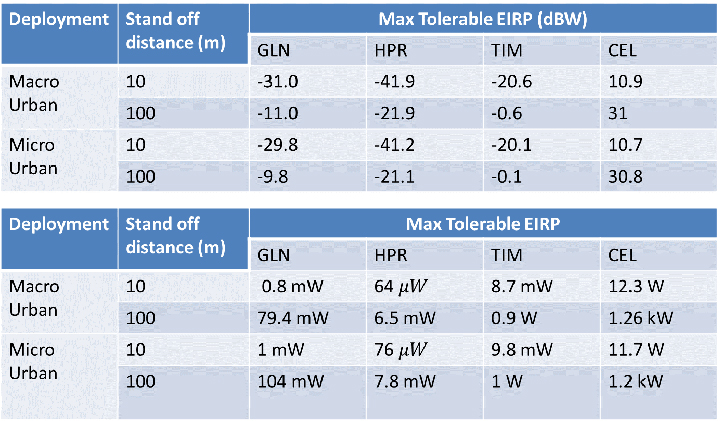
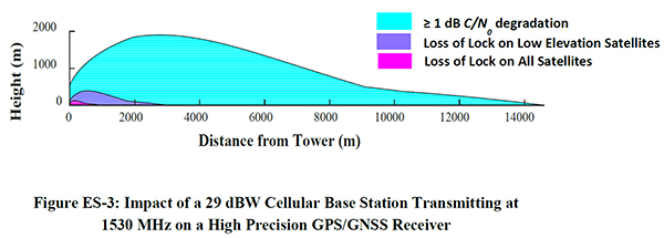
One thing that seems clear is that, with tolerable transmit power levels in the milliwatt and microwatt range, the potential to use the bands near GPS frequencies for commercial terrestrial wireless services may be limited. Illustrating that point further, the assessment shows that, based on the assumptions in the study, HPRs can be affected at distances beyond 14 kilometers (see Figure 2), and that loss of lock for low-elevation satellites can occur at distances of up to 3 kilometers from a base station providing terrestrial services using characteristics adopted internationally in the International Telecommunication Union (ITU) study groups.
Moreover, the assessment determined that the potential interference to other GNSS systems may be more problematic, noting that “the levels that protect all GNSS signals can be as much as 15 dB lower than those needed to protect L1 C/A signals from base station emissions with an average difference of 3.5 dB across all frequencies and five categories considered.”
Galileo’s Role. Since 2013, according to a Public Notice from the FCC, the European Commission has sought a waiver of FCC rules that require licensing of receivers operating with foreign satellites so that Galileo service can be provided in the United States. The FCC has yet to act on this waiver request, which was issued in a January 2017 Public Notice, despite overwhelming public support and a positive recommendation from the Executive Branch in 2015.
Conclusions
It is well known that all receivers take in some power from signals transmitted in nearby frequency bands. Considering this fact, the ABC assessment is relatively unique in that it examines the overall spectral environment in which GPS/GNSS operations can be affected rather than just the band allocated to the Radionavigation-Satellite Service (RNSS, the broad radiocommunication service defined in the ITU and in domestic rules under which GPS and other GNSS systems operate) between 1559–1610 MHz. That the overall environment should be considered is an important aspect of any discussion of protecting GPS and other GNSS services given the U.S. National Space Policy that was signed into effect June 28, 2010, that directs the U.S. government to “take necessary measures to sustain the radiofrequency environment in which critical U.S. space systems operate.” This policy is still in effect, and it would be difficult to argue that GPS is not a critical U.S. space system.
Recently, the reconstituted National Space Council adopted four recommendations, one of which related to spectrum used for satellite services and said that NTIA should coordinate with the FCC to ensure “the protection and stewardship of radio frequency spectrum necessary for commercial space activities.” Stewardship that is consistent with National Space Policy would include sustaining the RF environment for GPS.
As the PNT EXCOM has made clear, GPS is “vital to economic, public safety, scientific, and national security needs” of the U.S. Moreover, economic analysis presented to the PNT Advisory Board in 2015 estimated the economic benefit to the nation of GPS services at over 68 billion dollars annually. With the release of the ABC assessment, definitive information is now available to inform decisions on use of frequencies near those used to provide space-based PNT services so these critical services are not disrupted or degraded.


