No audio available for this content.
In the mountains of Northern California, a dangerously twisting stretch of road — the site of numerous fatal accidents — is being widened and realigned. Because it passes through the Six Rivers National Forest, the Highway 36 project is managed by the Federal Highway Administration (FHWA) in partnership with Caltrans.
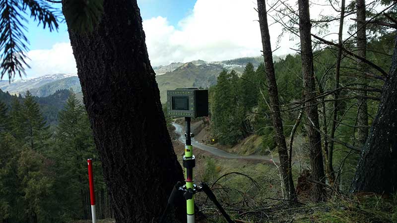
Surveyor Stephen Drake and his wife and business partner Mary Drake are using the Javad GNSS Triumph-LS to tackle the tricky assignment.
“We started this job in June 2017 shortly after founding Lost Coast Land Surveying,” Stephen explained.
“We ran slope staking and culvert cross-section/staking through about March 2018. We returned off and on to do topo mapping in areas that had landslides and other control surveys to support Mercer-Fraser [the construction contractor] grade-checking crews. We provided the control they calibrated their GPS systems to, based on the control we received from FHWA and Caltrans.”
Because of various troubles, such as landslides, the project is still a season from finishing, though the Drakes’ contribution is mostly complete.
The Drakes had tackled similar jobs, including on the Chiniak Highway near Kodiak, Alaska. Still, the task was daunting. The surveyors had to set catch points every 50 feet for four miles on both sides of the highway, 200 feet upslope and 100 feet downslope. “I have learned that the way to the end is one stake at a time, start, and keep going,” Stephen said.
The couple had to juggle home life with three boys with long days at the job site. Sometimes Mary had to remain home. “Usually I tried to hit more moderate slopes on those days,” Stephen said. “We bounced around the project a bit, some days only covering a 250-foot stretch because it was slow going scaling the slopes.”
The FHWA contracting officer, a veteran Federal Highways engineer, marveled at the efficiency of the modern surveying methods used by the Drakes, telling Stephen that two six-man crews used to be needed to accomplish what the couple could today.
“I will attribute a huge part of our efficiency to the Triumph-LS advantage,” Drake said, as well as the couple’s 20-year track record in environments as diverse as the Arctic, the Everglades and Arizona.
“During the course of the project we received a lot of comments from ‘I don’t know how you are doing this’ to ‘You are superhuman’ at one point,” Stephen said. “But it is just being tough, tenacious and Javad.”
All told, the surveyors set more than 2,000 stakes. “We got the toughest part of the job going for them,” Stephen said.


