No audio available for this content.
“Seen & Heard” is a monthly feature of GPS World magazine, traveling the world to capture interesting and unusual news stories involving the GNSS/PNT industry.
There’s an app for that
For 17 years, Kersey Valley Attractions in Archdale, N.C., created its annual corn maze by using a GPS-enabled tractor to cut paths out of grown corn. Instead of being limited by a tractor’s turning radius, this year’s “Maize Adventure” used a GPS planter programmed with a maze design from the MazePlay app. Based in Idaho, MazePlay provides maze design and cutting services throughout North America. The Apollo 11 example here is from Richardson Adventure Farm in Spring Grove, Illinois.

Just hit it already!
To speed play, officials for the PGA European Tour are using a GPS tracking system. Tracking devices were placed on one golf bag in each group in the BMW Championship, held Sept. 19–22 in Surrey, UK. When a group completed a hole, the information was sent to officials and displayed at five holes. Next year, all 18 holes will have displays, which include player names and indicate if the group is behind. The tour plans to increase fines for pace-of-play violations.
GPS makes it (too?) easy
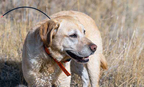
Animal rights groups are suing California over rules that allow animals to be hunted with the aid of hunting dogs wearing GPS tracking devices on their collars. The Animal Legal Defense Fund called the hunting method “unusually cruel and unfair” because tracking devices allow dogs to chase prey to the point of exhaustion, and then hunters follow the GPS signal to find an animal that can no longer flee and is easily shot. The lawsuit says the commission violated state environmental law by failing to conduct an assessment of how the use would affect wildlife.
Google Maps come alive
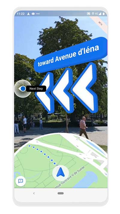
Google Maps is beta testing a new Live View feature, allowing travelers to use augmented reality (AR) to better see which way to go. Arrows and directions are placed in the real world to guide the walker. Google has tested Live View with its Local Guides and Pixel community for several months, and has now expanded the beta to Android and iOS devices that support ARCore and ARKit.


