No audio available for this content.
Parrot drones professional users benefit from an advanced control during complex fleet operations
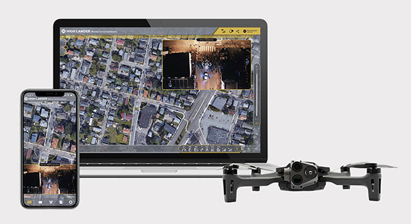
Drone company Parrot is partnering with High Lander, which provides drone fleets with autonomous flight, intelligent airspace control, and coordinated air continuity through its Mission Control platform.
Combining Parrot ANAFI USA and ANAFI platform drones with High Lander’s Mission Control software, professionals can now access drone features through an easy-to-use dashboard.
“Parrot is continuously striving to provide our professional users with extended capabilities — allowing them to rapidly adapt their drone operations to fit their changing and urgent needs,” said Jerome Bouvard, Parrot director of strategic partnerships. “Drone automation and intelligence are at the heart of our product and software developments. This new partnership with High Lander represents another step towards enhanced automation and control capability of our drones.”
Using real-time device reporting and telemetry, first responders can autonomously manage their drone fleets while performing takeoff and landing, route-planning, and other crucial tasks — all from the intuitive comfort of the Mission Control Operations Center dashboard. The software’s seamless interface paired with the ANAFI USA’s ease-of-operation and rapid deployment provide more safety for responders and allow faster intervention during critical moments. Mission Control’s customized live link generation can also provide team-members onsite with an instant view of a drone’s video feed for fast assistance during search-and-rescue missions.
For surveying and mapping missions, operators can use improved control modes including Path (which sets an automated plan including multiple waypoints, telemetric, gimbal and payload settings) and Modeling & Mapping (which allows operators to survey an area in detail) as they efficiently create 2D maps and 3D models using Parrot ANAFI’s precise GPS coordinates capabilities.
Operators can also benefit from Mission Control’s Payload Sidebar, which enables switching instantly to thermal imaging, an invaluable tool for missions in search and rescue, police pursuits, or solar panel inspections. Parrot ANAFI USA’s integrated FLIR Boson Thermal sensor and 32x zoom make it easy to identify thermal anomalies and centimetric hot spots from an altitude of up to 40 meters.
“As a hardware-free system, Mission Control is compatible with leading drone manufacturers’ solutions, now including Parrot, to provide our customers with the freedom of customizing their drone fleets with best-in-class UAVs,” said High Lander CTO Ido Yahalomi.
High Lander is working with a number of prominent organizations including police departments, sheriff’s offices, fire stations, and forestry services, and has 12 active clients who will now be able to use Parrot’s ANAFI USA and ANAFI drones in their fleets.
The High Lander Pilot app is available for download on Android and iOS systems for use with ANAFI and ANAFI USA platform drones.
For more information about ANAFI USA, contact Parrot through the ANAFI USA contact form.


