No audio available for this content.
The next-generation SLAM algorithm — GeoSLAM Beam — powers the new software
GeoSLAM has released a software update, Connect 2.0, at the Intergeo 2021 trade show. Intergeo is taking place this week in Hannover, Germany.
Connect 2.0 enables GeoSLAM scanners to achieve a higher level of accuracy compared to other SLAM-based mapping systems. Colorization from the new ZEB Vision panoramic camera provides even more visual context to a point cloud, as well as interactive “bubble” walkthroughs and measurements.
The update is powered with the next generation of GeoSLAM’s algorithm GeoSLAM Beam, which includes new filtering and georeferencing tools to help users get the best results from their datasets.
Connect 2.0 also simplifies data processing through a series of workflow scripts. This includes automatic data processing, stop-and-go georeferencing and stop-and-go alignment, all available as standard.

Connect 2.0 Features
- Intuitive interface – The Connect viewer is integrated into the main software interface, making it easy to view multiple point clouds simultaneously and measure the distance between data points.
- Change detection – Multiple point clouds can be compared, and any areas that have changed are automatically highlighted. Point clouds also can be compared with CAD models to track progress on a construction site or view changes between scans.
- Floor slices – Horizontal and vertical slices can be taken from any location within the point cloud. Horizontal floor slices can also be automatically taken at any given height above the floor.
- Environmental presets – Data is processed according to the environment it was captured in (indoor, outdoor, UAV or vehicle).
- Draw 4.0 – Draw projects can now be created automatically for any dataset.
GeoSLAM customers with a Care subscription will have full access to Connect 2.0. Any new product shipped starting today comes with both Connect and Hub software.
Real-time processing
GeoSLAM has also launched real-time SLAM processing through remote access. Using an API for remote data capture or automated robotic navigation, users can see the point cloud and trajectory in real time. The ZEB Revo RT can be used on and off a robotic platform.
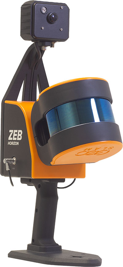
ZEB Vision panoramic camera
The ZEB Vision 16MP panoramic camera is now available for pre-order. Suitable for any ZEB Horizon, the new camera provides better colorization, image walkthroughs and pointcloud measurements using optional Draw software.
Use on UAVs. Further updates mean that GeoSLAM customers can now take a ZEB Horizon from handheld to UAV usage to get a more complete picture of projects. ZEB Horizon is compatible with the DJI Matrice 300 UAV.


