No audio available for this content.
Geoscience Australia is developing open-source software — named Ginan — that will provide real-time corrections to positioning signals of all the GNSS constellations.
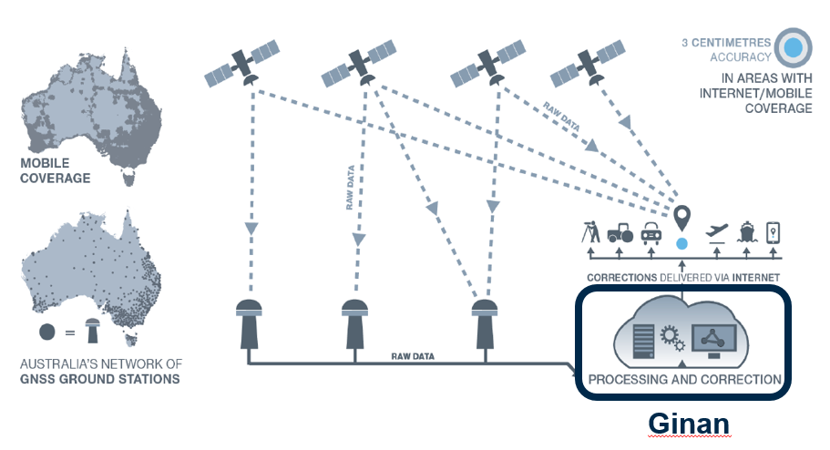
Once operational, Ginan will improve the accuracy of location data from 10 meters down to 3 to 5 centimeters for users with an internet and mobile connection. It will enable industry to provide reliable centimeter positioning to their customers, the agency said in a press release.
“Ginan is part of an exciting and innovative Australian Government program to enable precise positioning technology across the whole of the Australian continent,” said Martine Woolf, head of Geoscience Australia’s National Positioning Infrastructure Branch. “It will provide industry with the ability to use precise point positioning, bringing significant economic and social benefits to Australia.”
Examples of how this data could be used include reducing fertilizer and chemical spray waste in agriculture. It could also improve the operational efficiency of large mine sites through greater use of automation.
“Ginan will allow Australians to enjoy the benefits of precise positioning through the creation of new services and products, and in doing so, drive Australia’s economic growth,” Woolf said. “Our precise location data will inform of near real-time atmospheric conditions, which is already being used by the Bureau of Meteorology to assist with their weather predictions. It will also enable a greater understanding of movements in the Earth’s crust and provide insight into earthquakes, sea-level changes and the atmosphere.”
Ginan 1.0 will be publicly released in June 2022. An alpha version is now available on the Ginan GitHub repository, with a beta version planned for user testing from February 2022.
A thoughtful name
Ginan is named for a star that aided the First Australians as they navigated across the continent.
Woolf said the name of the software is a gift from the Wardaman people from the Northern Territory. Geoscience Australia sought permission to use the name Ginan as part of its commitment to respectfully engage and collaborate with Australia’s First Peoples.
“In the language of the Wardaman people, Ginan means ‘a red dilly-bag filled with songs of knowledge’. We like to think of this software as being similar to a dilly-bag full of knowledge because of the benefits it will unlock,” Woolf said. “Ginan is also the name of the fifth-brightest star in the Southern Cross. Just as the Southern Cross helped the First Australians to navigate this land, the positioning capability we are developing here at Geoscience Australia will enable us to know exactly where we are and where we are going.”
Wardaman Elder Diganbal Rosas said the dilly-bag was an important part of the Wardaman songline of the Katherine region. Songlines help to culturally and physically map land and seas through the transmission of traditional knowledge, cultural values, lore and wisdom across the landscapes. They are a living ancient memory code linking the environment, language and culture.
“Ginan [in our language] has all of the Wardaman knowledge regarding connection to country — all of the stars, the skies, the country, the people and the kinship. Everything we do is held in that dilly-bag, in that Ginan,” Rosas said. “The star teaches us many aspects of that spiritual connection to country, how it all began through those songlines, and how that story connects country to the stars. It is significant [that the Wardaman people have allowed Geoscience Australia to use this name] and I think it is a great opportunity for us to showcase our partnership.”
The Ginan initiative is part of Geoscience Australia’s Positioning Australia program, which is improving the accuracy of location-based data across the nation, bringing it from meters to centimeters.
Further information
Ginan Analysis Centre Software
Ginan GitHub repository
Positioning Australia