No audio available for this content.
3D measurement and imaging company Faro has joined with UAV provider Stormbee to offer an integrated airborne 3D scanning solution designed to quickly gather large area data for crash scene documentation, security pre-planning and military applications.
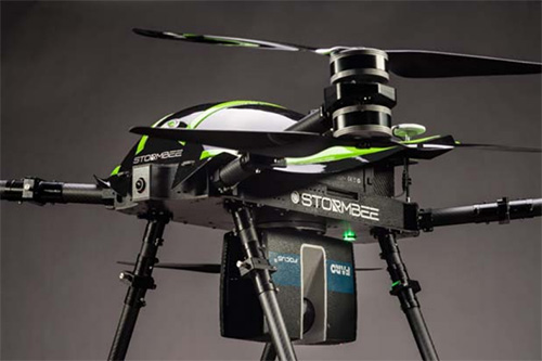
The integrated solution includes the Faro Focus laser scanner, the Stormbee S series UAV and the Beeflex software suite.
The airborne solution enables wide-area scanning missions, such as highways, train infrastructure, and buildings. While these would take days when scanned from the ground, they can now be completed in just hours without interrupting traffic or setting foot in a zone of interest.

The solution further enhances productivity by allowing users to capture complex environments where traditionally would be inaccessible to ground based scanning and levels of accuracy and detail from the air with exceptional.
The data can then download to FARO Zone for crash reconstruction, security pre-planning, military reconnaissance.
The Faro–Stormbee airborne solution has no need for control points, meaning is quicker to start scanning an area compared to other lidar drones. Drone pilots can fly with ease as it goes up to 100 meters (328 feet) in the air. With the drone’s integrated redundancy, even if a propeller or battery fails the UAV still flies.
“Stormbee has developed and validated its UAV credibility from real-life testing in the most rigorous environments,” said Liesbeth Buyck, CEO of Stormbee. “As a result, we are confident that this turnkey solution, that includes the Stormbee UAV and the FARO Focus laser scanner, creates a new reliability and quality benchmark for airborne 3D data capture solutions.”
Users can create centimeter-level accurate point clouds directly from the in-flight data. The user-friendly Beeflex software takes little training to use and can be exported directly into Faro Scene or Faro Zone 3D software for further analysis or to combine aerial scans with the detail-rich data from terrestrial scanners.
The Faro scanner can detach from the drone and be used as a terrestrial scanner or even a mobile mapper. This flexibility allows users to use one scanner in the air, on land or affixed to a vehicle.
Combined with Faro’s Focus laser scanner compact design, IP54 rating and laser technology users can scan a vast variety of scenarios, from large areas (railways, cities), areas with no light (tunnels, burned buildings), and hard-to-document areas (cluttered crime scenes, inside dumpsters).


