No audio available for this content.
Septentrio, Kespry share UAV advances; Game of Thrones, Mission Impossible also highlighted in GPS World webinar.
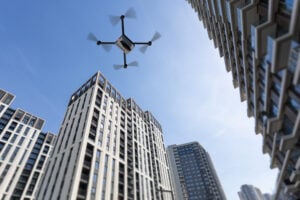
The UAV inspection industry continues to grow, as evidenced by these case studies of end-user application, presented in a free webinar available to readers of GPS World. As unmanned systems follow precise flight paths to gather data needed for missions in — to cite just a few examples — insurance, mining, construction and the pulp paper industry, they drastically reduce project time, workload and costs.
Narratives of how these tasks and other inspections are performed, and the requirements and challenges for positioning technology they pose, made up the October webinar, “Development Trends and Challenges for UAV Inspection Applications.”
Four expert speakers covered commercial applications in urban and remote areas, including issues generated by obstruction, interference and spoofing. The full webinar audio and slides are available for download.
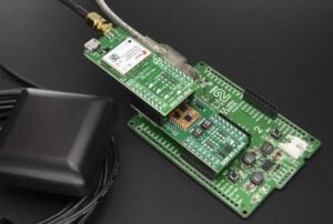
Septentrio. Gustavo Lopez, product manager for Septentrio, introduced the webinar and covered the main technical challenges and requirements for UAS inspection applications: reliable and accurate relative positioning and orientation; power efficient, vibration-robust technology; fail-safe systems; all-weather flying capability; long-duration precision flying; small data compression; sense and avoid mechanisms; and network centric infrastructure.
Lopez specified the capabilities an onboard GNSS receiver must have: interference monitoring and mitigation, and anti-spoofing — and briefly displayed the company’s products tailored for UAS inspection.
These include: AsteRx-m2, a single-antenna RTK/PPK base and rover; AsteRx-m2a, a dual-antenna RTK chip with 2D orientation; AsteRx-m2(a) UAS, an auto-pilot ready device for easy UAS integration; and AsteRx-i, a GNSS/inertial solution with RTK and 3D orientation.
Multi-Drone Mapping. Todd Humphreys from the University of Texas presented recent research developing the concept of collaborative mapping with multiple drones, creating a 3D display with decimeter accuracy. Ultimately the products from this prototype will serve in autonomous driving applications.
Humphreys displayed the Sensorium, an automobile equipped with stereo cameras, dual-antenna triple-frequency software-defined GNSS, an industrial-grade IMU, automotive radar, LTE connectivity — and a companion deployable UAV for reconnaissance.
Representing “eyes in the sky” for difficult or dangerous intersections. This little fellow carries a dual-antenna GNSS-IMU system developed in-house based on a software receiver delivering centimeter-accurate 2-degree UAV pose estimates.
The webinar then progressed to several Septentrio clients who are out on the leading edge of UAS inspections.

Kespry. UAV manufacturer Kespry provides a complete solution for construction and engineering companies to manage proposed and active earthwork operations. Without using multiple, cumbersome ground-control points, survey-grade field data can be collected for an entire site in as little as 30 minutes.
Attendees learned how drone technology is being used to:
- Validate proposed earthwork – reduce rework and extra earthmoving costs before the job begins
- Safely measure earthwork activity – ensure subcontractor work and delivered material are constantly measured
- Perform regular earthwork progress topos – accurately document completed grading and drainage phases.
Applied to insurance claims for inspections of roof damage, Kespry’s autonomous system improves safety, reduces loss adjustment expenses, and delivers more accurate assessments, while reducing overall costs.
For commercial property, the UAV solution helps prevent losses and informs underwriting decisions with high-resolution aerial and thermal imagery to identify exposures. Mobile tools are provided to review inspection imagery within minutes of flight; artificial intelligence technology generates fully dimensioned wireframes and 3D roof models.
Flying Cam. The webinar links to a YouTube video presentation by Flying-Cam CEO Emanuel Previnaire, showing exciting film footage from popular entertainment. Flying-Cam was closely involved in Game of Thrones, season 7, filming in Los Barruecos Natural Park in Spain; and Mission Impossible 6, filming in the heart of Paris.
The footage, delivered by the company’s UAVs flying very exact, high-speed pre-programmed flightpaths, was used to cinematically recreate flying dragons and exciting helicopter stunt work has been recognized over the years with two Oscars and one Emmy.
The Flying-Cam SARAH E unmanned helicopter, with a payload capability of 10 kg, is open to many sensor integrations. Recent projects have included several high-end sensors: magnetometer, hyperspectral camera system, lidar and more.
Flying-Cam introduced the specific use case of their customer Altametris, in a solution for rail inspection applications. Flying-Cam’s SARAH E successfully performed a lidar aerial survey in a populated area, the train station of Marseille Saint-Charles.
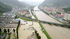
Altametris. A subsidiary of the French National Railway (SNCF), one of the densest and most complex networks in Europe, Altametris participates in monitoring and inspecting a system encompassing 58,000 kilometers of track, 1,700 tunnels, 27,000 bridges and 3,000 stations by using non-intrusive measurement methods (UAVs, robots and more).
Challenges for beyond-visual-line-of-sight (BVLOS) inspections of this vast network include countless obstructions, safety and regulations governing flights over populated areas, and the need to avoid interference with railway operations.
A typical rural scenario of long-range inspection involves a fixed-wing UAV with camera, lidar, multispectral camera and other sensors, flying at 150-meter altitude over a 50- to 100-kilometer stretch. Urban inspection uses rotary-wing UAVs with camera and lidar at even lower altitude (50 meters), along a 5-kilometer corridor.
Employing GNSS/INS solution for positioning and georeferencing combined with lidar leads to precise and valuable data (high-density point cloud, up to 1000 points/square meter). A highly accurate and robust GNSS system is also mandatory for safety and security as it could help to monitor and avoid drone fly-away.
Robust GNSS systems are therefore a key technology for the UAV industry and could open new business opportunities, through safe deployment in inhabited areas, high quality data for metrology,and more.
For full details on all the above, download the free webinar audio and slides.