No audio available for this content.
Providing high-speed internet access to businesses and residences is a highly active and expanding field. It closely involves geographic information systems (GIS) to efficiently achieve fiber to the home (FTTH) or fiber to the premises (FTTP), the installation and use of optical fiber from a central point directly to individual buildings such as residences, apartment buildings and businesses for high-speed internet access.
A free webinar on Jan. 18 will cover — among several other related topics — the integration of high-accuracy aerial imagery into this process. David K. Nelson, GISP, a GIS manager in telecommunications for Black & Veatch, will make the presentation. It will be complemented by a talk on how to “Plan Virtually, Manage Efficiently with High-Definition (HD) Aerial Maps” by imagery provider Nearmap, and one on use of HD aerial imagery for city storm-water management.

Nelson is responsible for developing GIS solutions for projects with the Black & Veatch’s telecommunications division. With over 13 years of experience in public and private sectors, Nelson is a visionary for adopting and enabling geospatial technologies and location content that drive operational efficiency. His presentation will cover such topics as GIS-centric approach for all projects; file-based vs. data-based transition; geospatial archives of all data; and integration with other technology platforms.
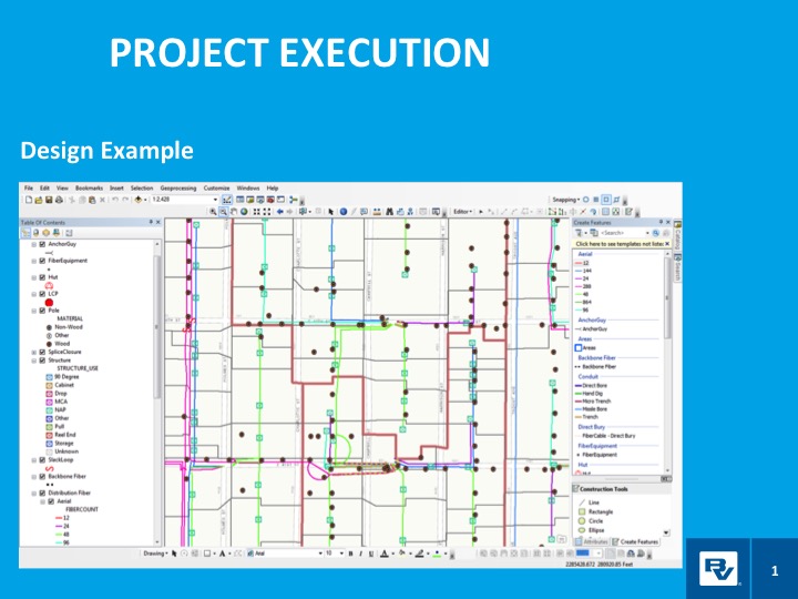
In a case study, he will take webinar attendees through a FTTH project design and execution example.
Black & Veatch is an engineering, consulting and construction company with more than 100 offices worldwide, specializing in infrastructure development in power, oil and gas, water, telecommunications, government, mining, data centers, smart cities and banking and finance markets.
The annual Black & Veatch Strategic Directions: Smart Cities & Utilities Report explores progress made across the smart city and smart utility landscape. This year’s report examines how modern, digital infrastructure is being used to optimize operations and create a sustainable future for our cities and utilities.
“From urban mobility to the proliferation of electric vehicles, transportation is changing rapidly, inviting opportunity in how people and goods move across cities. The next generation of wireless technology is upon us, further encouraging connectivity and enabling smart cities in myriad ways. Grid modernization continues as utilities work to create a customer-centric grid through a combination of smart devices, distributed energy and communications.”
Read more about the free webinar: “Truth on the Ground is Best Seen from the Air: How aerial imagery is propelling government and commercial organizations to higher levels of operational efficiency.”
Advances in aerial imagery including high-resolution maps and a streamlined process to capture, manage and deliver imagery in the cloud is transforming the way governments and businesses operate. With Aerial photography and instant access to current 2.8-in. GSD aerial views, Black and Veatch has increased efficiency in their telecommunications projects including assessment of ground conditions, construction and asset management. In Indiana, The City of Carmel’s Engineering Department has applied aerial imagery to enhance planning, operations and storm water management.
In this webinar, you will:
- Learn about the latest advances in aerial imagery including how imagery is supporting a variety of government and business applications today
- See real-world use cases of imagery in telecommunication, engineering and city government to improve operational efficiency
- Understand how imagery can be used standalone and within GIS and CAD products
- See the latest demos of Nearmap imagery including vertical, panorama and oblique views