No audio available for this content.

A famous quote applies to almost everything in our lives: “There is nothing permanent except change.”
This well-known saying is generally credited to the Greek philosopher Heraclitus (500 B.C.E.), although many historians and philosophy experts tend to agree the quote is a combination of many topics found in writings by Heraclitus.
However the quote came to be, it aptly describes the world we live in; especially now with lightspeed advancements in technology. Change is markedly evident in today’s surveying world, and almost no practitioner is exempt from revolutionary enhancements and necessary upgrades to stay current in our profession.
Change is on the horizon

The upcoming NGS 2022 datum change, triggered by advancements in positional accuracies and measurement techniques, has quietly created a groundswell of questions, concern and curiosity of how and why we are at these crossroads. In my September 2019 Survey Scene article, we discussed the background behind the necessity of the upgrade and moving toward a standardized measurement unit, (the “foot”). (For purposes of this article, let’s put aside any mention of using the meter/metric system; the U.S. went down that road in the late 1970s / early 1980s, yet crashed and burned upon implementation. I agree the meter is a more practical unit of measurement, but we need to leave that talk for another day.)
This article will be concentrating on the actual coordinate systems and how significant changes are coming for almost everyone performing surveying measurements. Yes, this means all those construction-based users of GNSS receivers and total stations performing pre-, in-progress and post- construction tasks. Our coordinate world will be turning upside down but, in this case, it will be changes for the good.
Origins of X/Y (otherwise known as Northing/Easting)
We have another philosopher to credit for the concept of coordinate geometry; he is the French scientist Rene Descartes (1596-1650) who was heavily influenced by Plato.
While he may be more well known for his famous quote “I think, therefore I am,” Descartes created what is believed to be the first graphical depiction of geometrical expressions and assigning coordinate values to the results; hence the background behind “Cartesian coordinates.” It is this coordinate system that was utilized by late 1800s/early 1900s surveyors who began using this system to create small networks within urban settings, including New York City, Cincinnati and Atlanta.
As economic expansion continued through the Great Depression and beyond, the need for larger survey networks became more evident. The first state plane coordinate system (SPCS) began in North Carolina in 1933-34 with more states quickly falling in behind them. The main force behind this effort was the U.S. Coastal & Geodetic Survey (now known as National Geodetic Survey), as they utilized many surveyors and engineers that were unemployed due to the Stock Market Crash of 1929 and Great Depression. Technology for the era was limited to theodolites and steel tapes, with most computations being based upon triangulation.
Enter the Electronic Age of surveying

Positional and measurement technology remained stagnant until the 1950s and 1960s with the introduction of the electronic distance meter (EDM). Longer measurements could be made with increased accuracy and helped expand our coordinate system capabilities.
These enhancements also led to faster expansion of a nationwide highway system (championed by President Dwight Eisenhower) by simply surveying more efficiently. It is along these highway corridors that state plane coordinate systems were expanded into remote areas and used to verify fractured SPC systems created through solar and/or astronomical means. While positional values at common monuments were found to have significant differences by today’s standards, most error was distributed throughout the network.
Because of the work necessary to complete a survey using a SPCS, it was not practical for any non-governmental project to attempt tying into a known system. Fundamental use of coordinate geometry (CoGo) typically utilized a project base point with a low assumed positional value, (i.e. northing of 1,000, easting of 2,000).
Most surveyors used the same coordinate values for each project and did not have any positional relationship between their projects. While the field portion of the project took a significant amount of time to traverse and collect, the office calculations and manual drafting were also tedious and time-consuming tasks.
Prior to the introduction of the handheld calculator in the early 1970s, traverse computations were completed manually using sine/cosine/tangent tables, traverse adjustment (i.e. compass, transit and Bowditch rule) and double distance meridian (DMD) methods. Even as the programmable calculator became the computation method of choice, regularly producing survey data in SPCS was still years away.
Along with the electronic theodolite and the personal computer with computation software, the introduction of the data collector quietly revolutionized the amount of data that could be stored and efficiently plotted for surveys. But even with the increased efficiencies, there was one big drawback to utilizing this electronic data collection with SPCS; most hardware was limited to values and significant figures not acceptable to using large coordinate values. Some tried truncating SPCS values but often found the trouble not worth the effort, not to mention having projects large enough to be affected by grid-to-ground scale factors (another topic for another day).
Fast forward to the 1980s and the introduction of ultimate surveying black box, the GPS receiver. Positional accuracy through static GPS sessions was now better than ever and allowed surveyors to cover greater distances in shorter time periods. It was the implementation of the GPS receiver (and subsequent reduction in cost of entry for its use) that allowed the surveyor to embrace the state plane coordinate system more than ever. Also addressed with the new technology was the ability for the data collector to handle larger coordinate values with increased significant figures.
As RTK and subsequent RTN systems have allowed for more efficient use of GNSS technology, the surveying profession has now overwhelmed the existing monument network and exposed the deficiencies of NAD83 and our various SPCS zones nationwide. NGS has done an excellent job for many years refining and adjusting the national datums (both horizontal and vertical) by augmenting the systems with new data and “turning the screws” as deemed necessary to provide a reliable network.
If it is not broken, why fix it?
The existing SPCS zones and overall NAD83 system works well but we will need to circle back to the quote in the opening paragraph: “There is nothing permanent except change.”
Research, not just completed by NGS but many other respected agencies and laboratories worldwide, has shown that our existing datums have significant flaws due to many factors. These factors include, but are not limited to, tectonic plate shifting, previous survey data that doesn’t meet today’s positional and measurement standards, and limitations in terrestrial measurements.
We are overdue for an upgrade to the national system and design of new policies and procedures has taken time and lots of hard work. NGS has created a new framework that will adapt to the changing needs of a state and/or regional authority.
But what does this mean for the surveyor, the contractor and anyone else in the geospatial world that uses state plane coordinates for the basis of data?

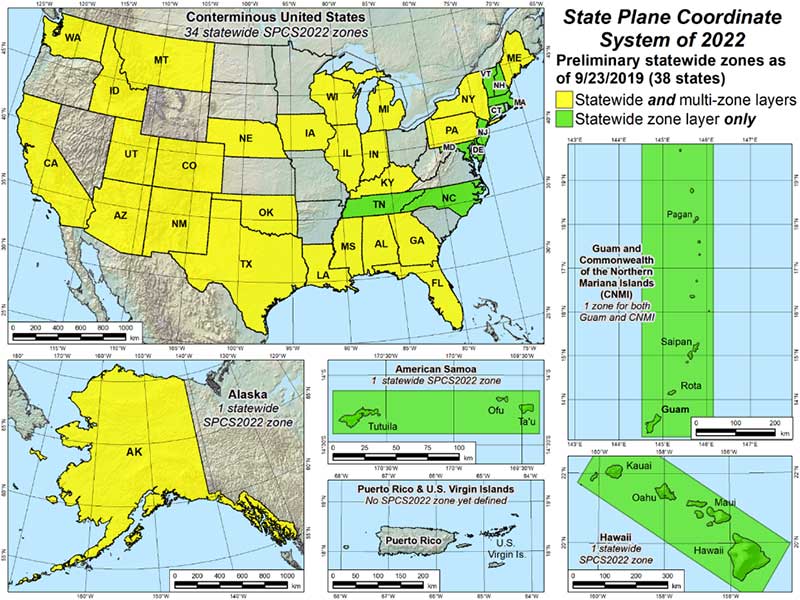
As discussed in the last article, NGS has been busy creating a new framework with a proposed implementation of 2022-2023. While NGS is creating the specifications, policies and procedures for the new system, it will be up to each state to decide if they want to keep their existing SPCS zones, change to a new scheme, and/or request that additional smaller zones be included for consideration. NGS, in keeping with existing policy, will work with each state to update their SPC definitions, but only if the state engages NGS during the setup period. Otherwise, NGS will apply the new datum specification to the existing zone(s).
What does this mean to the everyday surveyor?
For an example on how a state can revise their SPCS, let’s use Illinois and its plan to revise current zones. Illinois currently implements a two-zone system (East and West, lengthwise through the state) based upon a transverse Mercator projection.
For several years, GIS users and other agencies have discussed creating a single-zone system across the entire state for ease of use. Because of the size of the state and availability of RTN coverage to some remote areas, the realization of this new system has been on hold. Also, it is understood the distortion in data accuracy across a system this large would not be suitable for survey-grade applications.
Forward to 2019 and the NGS datum upgrade along with a substantial effort by several equipment manufacturers to install CORS stations across the state for broader RTN coverage (and the not-too-distant future rollout of 5G cellphone service). RTN coverage for mapping grade data collection is now readily available nearly everywhere in Illinois, so the potential of a single-zone system is now not far-fetched.
It should be noted that if Illinois decides to convert to a single-zone system, NGS will only recognize that system for future computations and documentation and the two-zone system will be scrapped. It will fall to each practitioner to convert their existing data and projects to the single-zone system if they choose to use it, but it will have some drawbacks due to the distortion of the larger system.
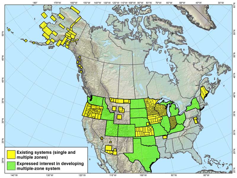
Enter the low distortion projection (LDP) system. Like other states, Illinois is discussing a potential LDP system containing 32-34 regions statewide for more accurate coordinate system development. These regions are being studied to concentrate on larger urban centers and areas where growth potential is predicted. Regions such as the Chicago, St. Louis and Peoria metropolitan areas are being highlighted for major LDP system use by not just surveyors but government and GIS analysts.
Having a coordinate system with less distortion and more accuracy can provide more reliable information for the survey but also provide more value for the residents and businesses. By concentrating the coordinate system on smaller areas through an LDP, surveyors will literally be using a communal network like their old calibrated or localized network systems of days past. The coordinates will still be large but the integrity of the data will be higher due to the reduced distortion of the system projection.
This system will also virtually eliminate the need to have a grid-to-ground scale factor because of the lack of distortion. So we will now have a large statewide system for mapping and smaller regional systems for accurate survey data going forward; sounds like a good plan, right?
Making a significant change increases our capabilities
Not to sound like a broken record, but let’s revisit the quote by Heraclitus one more time: “There is nothing permanent except change.”
Most people don’t like change, even if it is for the better. Surveyors are notoriously famous for not wanting change. Many surveyors I know would not embrace early GPS not simply due to cost, but more of not understanding how it works. They also didn’t understand how to embrace state plane coordinates and having survey data that will be compatible with their competitors. Most of those surveyors now are using it, but only because the data collectors have become more user friendly.
But why will this change be harder for most? Depending on where one is and how their state is going to adapt will affect that change. If your state is not changing any zones, they will have a -2 to +4.5-meter coordinate shift depending on where they are located. For states like Illinois and potentially changing from two zones (East and West) to a single zone and dozens of regional LDP systems, it will be a bit harder to translate all your existing survey data to the new systems if necessary.
There are several potential pitfalls in front of us if we aren’t careful. Here are a couple of scenarios to consider:
- Understanding the general change in datum values
- Converting old data to new system for reuse (additional time consideration)
- For practitioners working in several LDP regions, emphasize the importance of correct zone
- Software and equipment firmware updates
- Older unsupported data collectors
- Compatibility with current and archived GIS data
- Conversions of government agency-specific data and benchmark
Major milestone dates:
- Establishing a date in which all new survey data will use the new datum
- Establish a date in which all design projects will utilize the new datum
- Establish a date when all construction layout will utilize the new datum
These zone/LDP system changes also will be affected if your state is currently recognizing the U.S. Survey Foot and will be changing to the “foot” per my last article and ongoing NGS discussions. That change will also precipitate additional review and care for compliance of any old data to new systems.
As creatures of habit, change and adaptation moves us forward
Here’s the bottom line: We need to make this change in order to efficiently address future mapping needs and positional accuracies. Because of technology and evolution of measuring devices, we now know there are other factors that play into our coordinate systems.
As the world becomes more reliant on digital data and information, it will be critical that the right geospatial information is tied to it. There is nothing permanent except change, but change can also be for the better.


