
No audio available for this content.
25 years on the path to multi-GNSS
As Galileo, BeiDou, the Quasi-Zenith Satellite System, the Indian Regional Navigation Satellite System, and a variety of satellite-based augmentation systems join GPS and GLONASS, we help celebrate the coming 25th anniversary of the IGS as a truly multi-GNSS service.
Editor’s note: Tables 1 and 3 in the print version of this article contain some incorrect values and missing designators. These errors have been corrected in the tables below.

A QUARTER OF A CENTURY. That is how old the International GNSS Service (IGS) will be on Jan. 1, 2019. Conceived in the early 1990s as the International GPS Service for Geodynamics, the IGS continues to be the global standard bearer in providing receiver data, satellite orbit and clock products and other resources with the highest possible precision and accuracy. I remember the discussions that took place at international conferences about the need for such a service to provide the necessary data to advance our understanding of plate tectonics and other Earth-related phenomena. And this was well before GPS was officially declared fully operational in 1995. Remember, surveyors and geodesists were early adopters of GPS, making use of the technology even when only a partial GPS constellation was in place.
The initial ideas for the IGS were laid out in an article published in GPS World in February 1993 entitled “Geodynamics: Tracking Satellites to Monitor Global Change.” But the services provided by the IGS extended well beyond the needs of the geodynamics research community, and so its name was shortened to just the International GPS Service. When GLONASS data and products became available, the name was further changed to its current moniker.
One of the IGS’s notable achievements has been in advancing GNSS standards such as the Receiver-Independent Exchange format for receiver data and other information. The need for such a standard was clear even before the formation of the IGS, and it was documented in this column in the July 1994 issue of GPS World (“RINEX: The Receiver-Independent Exchange Format”). We continued to cover the evolution of the IGS over the years with, for example, the article “The International GNSS Service: Any Questions?” in the January 2007 issue of the magazine.
And now, as Galileo, BeiDou, the Quasi-Zenith Satellite System, the Indian Regional Navigation Satellite System, and a variety of satellite-based augmentation systems join GPS and GLONASS, we help celebrate the coming 25th anniversary of the IGS as a truly multi-GNSS service.
For going on 25 years, the International GNSS Service (IGS) has carried out its mission to advocate for, and provide, freely and openly available high-precision GNSS data, as well as derived operational data products, including satellite ephemerides, Earth rotation parameters, station coordinates and clock information. The IGS is a self-governed, voluntary federation of more than 300 contributing organizations from more than 100 countries around the world that collectively operate a global infrastructure of tracking stations, data centers and analysis centers to provide high-quality GNSS data products. The IGS products are provided openly for the benefit of all scientific, educational and commercial users.
The IGS was first approved by its parent organization, the International Association of Geodesy (IAG), at a scientific meeting in Beijing, China, in August 1993. A quarter of a century later, the IGS community gathers for a workshop in Wuhan, China, this November to blaze a path to multi-GNSS through global collaboration.
As a key component of the IAG’s global geodetic infrastructure, the IGS contributes to, extends and densifies the International Terrestrial Reference Frame (ITRF) of the International Earth Rotation and Reference Systems Service (IERS). The ITRF provides an accurate and consistent spatial frame for referencing positions at different times and in different locations around the world.
In addition, IGS products enable the use of GNSS technologies for scientific applications such as the monitoring of solid Earth deformations, monitoring of Earth rotation and variations in the liquid Earth, and for scientific satellite orbit determinations, precise timing, ionosphere monitoring and water vapor measurements.
IGS products are also considered critical by surveying, geomatics and geo-information users around the world, who rely on them on a daily basis to improve efficiency. Many applications that require reliable, accurate GNSS positioning in construction, agriculture, mining, exploration and transportation also benefit from the IGS.
Community Collaboration
At the heart of the IGS is a strong culture of sharing expertise, infrastructure and other resources for the purpose of encouraging global best practices for developing and delivering GNSS data and products all over the world. The collaborative nature of the IGS community leverages this diversity to integrate and make full use of all available GNSS technologies while promoting further innovation.
More than 15,000 geodetic community members, some of whom comprise the backbone of the worldwide geodetic community, ensure that new technologies and systems are integrated into operational IGS products. Responsive to this innovation, the IGS develops and publicly releases standards, guidelines and conventions for the collection and use of GNSS data and the aforementioned products.
The IGS strives to maintain an international federation with committed contributions from its members. Participation of individuals and organizations is often driven by user needs, a key characteristic of the inclusive culture within the IGS.
Structure of the IGS
The IGS consists of a central bureau, a global network of GNSS stations, data and analysis centers and a number of working groups all coordinated and overseen by a governing board.
Central Bureau. The IGS Central Bureau (CB) functions as the secretariat of the IGS, providing continuous management and technology to sustain the multifaceted efforts of the IGS in perpetuity. The CB responds to the directives and decisions of the IGS governing board. It coordinates the IGS tracking network and operates the CB information system, the principal information portal where the IGS web, FTP and mail services are hosted (www.igs.org). The CB also represents the outward face of IGS to a diverse global user community, as well as the general public. The CB office is hosted at the California Institute of Technology/Jet Propulsion Laboratory in Pasadena, California. It is funded principally by the U.S. National Aeronautics and Space Administration (NASA), which generously contributes significant resources to advance the IGS.
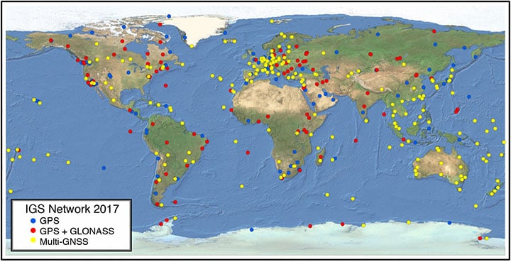
The IGS Network. The foundation of the IGS is a global network of more than 500 permanent and continuously operating stations of geodetic quality. These stations track signals from GPS, and increasingly also track signals from GLONASS, Galileo, BeiDou, the Quasi-Zenith Satellite System (QZSS), the Indian Regional Navigation Satellite System (IRNSS; also known as NavIC: Navigation with Indian Constellation), as well as space-based augmentation systems (SBAS).
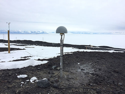
FIGURE 1 shows the recent state of the IGS network, indicating which stations are GPS only, GPS+GLONASS and multi-GNSS. FIGURE 2 is a photo of the IGS station ARHT at McMurdo Station, Antarctica.
The IGS is a critical component of the IAG’s Global Geodetic Observing System (GGOS), where it encourages and advocates for geometrical linkages of GNSS with other precise geodetic observing techniques, including satellite and lunar laser ranging, very long baseline interferometry and Doppler Orbitography and Radio Positioning Integrated by Satellite (DORIS). These linkages are fundamental to generating and accessing the ITRF.
Data and Analysis Centers. Lots of hard work and dedication from IGS contributing organizations goes into the fabrication of IGS products, which start at the tracking network, then are collected by data centers and sent to analysis centers. At these centers, the data are compared and combined by the analysis center coordinator, and finally made available as IGS products.
The IGS ensures high reliability by building redundancy into all of its components. In 1994, the IGS started with a network of about 40 stations; today, more than 500 receivers are included in the network. Critical to this activity are three categories of data center — operational, regional and global. At the ground level are operational data centers, which are in direct contact with IGS tracking sites and are responsible for such efforts as station monitoring and local archiving of GNSS tracking data. Operational data centers also validate, format, exchange and compress data. Regional data centers then collect tracking data from multiple operational data centers or stations, maintaining a local archive and providing online access to their data.
The six global data centers receive, retrieve, archive and provide online access to tracking data from operational and regional data centers. These global data centers are also responsible for archiving and backing up IGS data and products, and maintaining a balance of data holdings across the IGS network.
Analysis centers then receive and process tracking data from one or more data centers to generate IGS position, orbit and clock products. These products are produced in ultra-rapid, rapid, final and reprocessed versions for each analysis center.
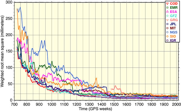
FIGURE 3 shows the huge improvement in the precision and accuracy of the final orbit submissions from the analysis centers over the past 25 years.
Associate analysis centers produce specialized products, such as ionospheric information, tropospheric parameters or station coordinates and velocities for global and regional sub-networks. Regional and global network associate analysis centers complement this work as new capabilities and products emerge within the IGS.
Products from each analysis center are then combined into a single set of orbit and clock products by the analysis center coordinator, who monitors and assists the activities of analysis centers to ensure IGS standards for quality control, performance evaluation and analysis are successfully executed. The different analysis solutions ultimately verify the accuracy of IGS products, provide important redundancy in the case of errors in a particular solution, and average out modeling deficiencies of a particular software package.
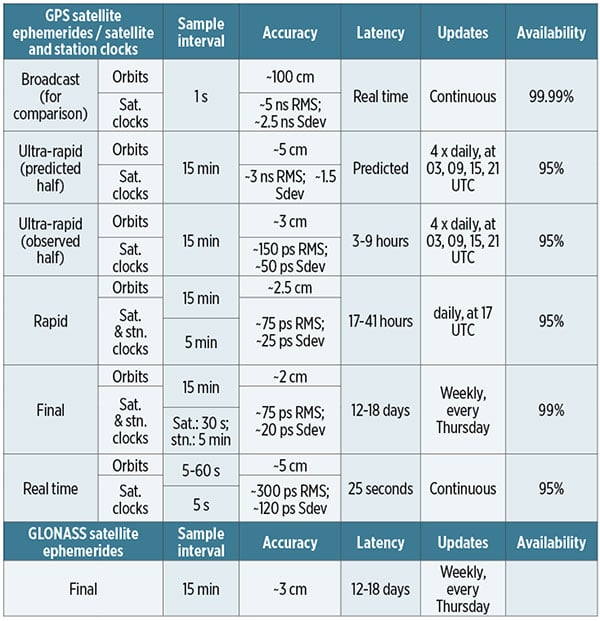
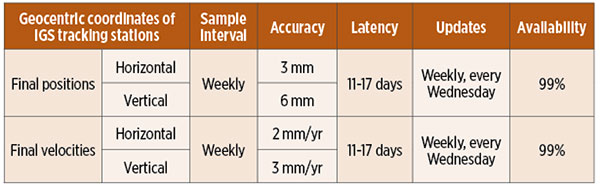
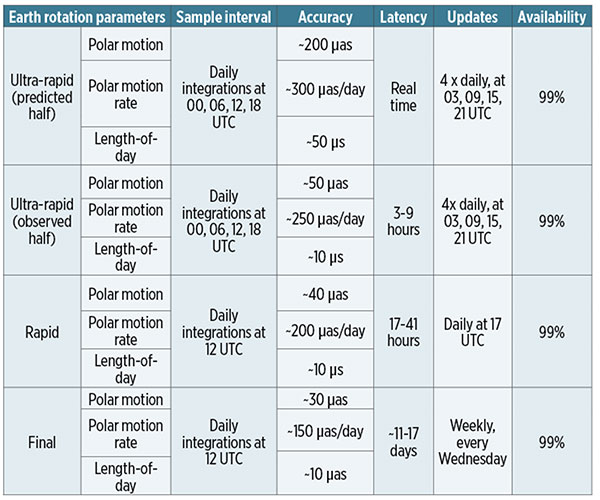
TABLE 1 shows the quality of service characteristics of the various IGS GPS and GLONASS orbit and clock products. Similarly, TABLES 2, 3 and 4 show the characteristics of the tracking station coordinates, Earth rotation parameters and atmospheric parameters. See www.igs.org/products for further details.

Working Groups and Projects
The IGS technical working groups (WGs) focus on topics of particular interest to the IGS, and consider various aspects of product generation and monitoring. The current working groups of the IGS span topics from antennas to tide gauges.
Antenna Working Group. To increase the accuracy and consistency of IGS products the Antenna WG coordinates research on GNSS receiver and satellite antenna phase-center determination. The group manages official IGS receiver and satellite antenna files and their formats.
Bias and Calibration Working Group. Different GNSS observables are subject to different satellite biases, which can degrade the IGS products. The Bias and Calibration WG coordinates research in the field of GNSS bias retrieval and monitoring.
Clock Products Working Group. This group is responsible for aligning the combined IGS products to a highly precise timescale traceable to the world standard: Coordinated Universal Time (UTC). The IGS clock product coordinator forms the IGS timescales based on the clock solutions of IGS analysis centers, and IGS rapid and final products are aligned to these timescales.
Data Center Working Group. The Data Center WG works to improve the provision of data and products from the operational, regional and global data centers, and recommends new data centers to the IGS governing board.
Joint GNSS Monitoring and Assessment Working Group. This working group, in conjunction with a joint trial project with International Committee on GNSS’s (ICG) International GNSS Monitoring and Assessment (IGMA) Task Force, seeks to install, operate and further develop a GNSS Monitoring and Assessment Trial Project.
GNSS Performance Monitoring ICG-IGS Joint Trial Project. The quality of navigation signals enables numerous applications, including worldwide time and frequency transfer and GPS meteorology. This project of the IGMA task force, coordinated in partnership with the IGS, focuses on monitoring GNSS constellation status.
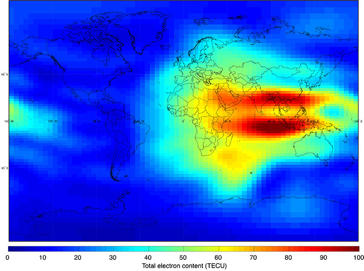
Ionosphere Working Group. This group produces global ionosphere maps of ionosphere vertical total electron content (TEC). A major task of the Ionosphere WG is to make available global ionosphere maps from the TEC maps produced independently by ionosphere associate analysis centers within the IGS.
FIGURE 4 shows an example TEC map recomputed from data collected on March 17, 2015. The large values of TEC in the ionosphere’s equatorial anomaly are plainly visible.
Multi-GNSS Working Group. This group supports the Multi-GNSS Experiment (MGEX) Project by facilitating estimation of intersystem biases and comparing the performance of multi-GNSS equipment and processing software. The MGEX Project was established to track, collate and analyze all available GNSS signals including those from BeiDou, Galileo and QZSS in addition to GPS and GLONASS.
Reference Frame Working Group. This working group combines solutions from the IGS analysis centers to form the IGS station positions and velocity products, and Earth rotation parameters for inclusion in the IGS realization of ITRF. A new reference frame, called IGS14, was adopted on Jan. 29, 2017 (GPS Week 1934). At the same time, an updated set of satellite and ground antenna calibrations, igs14.atx, was implemented.
Real-Time Working Group. The Real-Time WG supports the development and integration of real-time technologies, standards and infrastructure to produce high-accuracy IGS products in real time. The group operates the IGS Real-Time Service (RTS) to support precise point positioning (PPP) at global scales, in real time.
RINEX Working Group. The RINEX-WG jointly manages the Receiver-Independent Exchange (RINEX) format with the Radio Technical Commission for Maritime Services Special Committee 104 (RTCM-SC104). RINEX has been widely adopted as an industry standard for archiving and exchanging GNSS observations, and newer versions support multiple GNSS constellations. Recently, the IGS governing board agreed to adopt the official RINEX V3.04 format, handling the ability for nine-character station ID and fixing the definition of GNSS reference time scales.
Space Vehicle Orbit Dynamics Working Group. This group brings together IGS groups working on orbit dynamics and attitude modeling of spacecraft. This work includes the development of force and attitude models for new GNSS constellations to fully exploit all new signals with the highest possible accuracy.
Troposphere Working Group. The Troposphere WG supports development of IGS troposphere products by combining troposphere solutions from individual analysis centers to improve the accuracy of PPP solutions. The goal of the Troposphere WG is to improve the accuracy and usability of GNSS-derived troposphere estimates.
Tide Gauge (TIGA) Working Group. When studying sea level changes, where the GPS height of the benchmark is used for defining an absolute sea-level datum, problems occur when correcting the time series for height changes of the benchmark. TIGA is a pilot study for establishing a service to analyze GPS data from stations at or near tide gauges in the IGS network to support accurate measurement of sea-level change across the globe.
A Multi-GNSS IGS Network
The development of a multi-GNSS sub-network within the greater IGS network, led by the MGEX Project, develops the IGS’s capability to operate with multiple GNSS constellations. It has 223 multi-GNSS-capable (GPS + GLONASS + at least one other constellation) stations. Also, the number of IGS stations capable of real-time data streaming in support of the IGS Real-Time Project has increased to 195.
MGEX was founded in 2012 to build a network of GNSS tracking stations, characterize the space segment and user equipment, develop theory and data-processing tools, and generate data products for emerging satellite systems. The stations within its network contain a diverse assortment of receiver and antenna equipment, which are recognized and characterized by the IGS in equipment description files. Other than GPS and GLONASS, no combination process has yet been implemented within IGS for precise orbit and clock products of the other, newer, constellations. Despite this, cross-comparison among analysis centers, as well as with satellite laser ranging, has been used to assess the precision or accuracy for various products.
The growing role of multi-GNSS within the IGS network was benchmarked by the transition of MGEX to official IGS project status in 2016. For the sake of consistency, and as a nod to its heritage, use of the acronym “MGEX” has been retained.
Making Strides in Real Time
Through the Real-Time Service (RTS), the IGS extends its capability to support applications requiring real-time access to IGS products. The RTS is a GNSS orbit and clock correction service that enables PPP and related applications, such as time synchronization and disaster monitoring, at worldwide scales. The RTS is based on the IGS global infrastructure of network stations, data centers and analysis centers that provide world-standard high-precision GNSS data products.
The RTS is currently offered as a GPS-only operational service, but GLONASS is initially being offered as an experimental product for the development and testing of applications. GLONASS will be included within the service when the IGS is confident that a sufficient number of analysis centers can ensure solution reliability and availability. Other GNSS constellations will be added as they become available.
Engagement with the United Nations
The IGS engages with diverse organizations, outside of the immediate precise GNSS community, that have an interest in geodetic applications of GNSS. Notably, the IGS has supported the development of the Global Geodetic Reference Frame resolution, roadmap and implementation plan within the United Nations Global Geospatial Information Management (GGIM) Committee of Experts.
The IGS also works with the United Nations Office for Outer Space Affairs (UNOOSA) International Committee on GNSS (ICG) to develop common understandings of the requirements for multiple system monitoring through the joint pilot project with the ICG’s IGMA subgroup. The IGS also co-chairs ICG Working Group D, which focuses on reference frames, timing and applications.
A Multi-GNSS Future
Though the accuracy of current IGS multi-GNSS products lags behind standard IGS products for GPS and GLONASS, multi-GNSS paves the way for complete exploitation of new signals and constellations in navigation, surveying, geodesy and remote sensing.
IGS also looks externally to other techniques through its participation in the IAG’s GGOS, which has illuminated how satellite laser ranging observations to GNSS satellites improves our understanding of observational errors and thus drives further improvement of IGS position, clock and orbit products.
As it enters its second quarter-century, the IGS is evolving into a truly multi-GNSS service. For 25 years, IGS data and products have been made openly available to all users for use without restriction, and continue to be offered free of cost or obligation. In turn, users are encouraged to participate within the IGS, or otherwise contribute to its advancement.
Acknowledgements
The authors gratefully acknowledge the contributions of the IGS governing board and associate members in the drafting of this article. Special thanks to Anna Riddell and Grant Hausler, who, along with Gary Johnston, have an extensive chapter on IGS in the Springer Handbook of Global Navigation Satellite Systems, published in 2017 by Springer (see Further Reading). This book chapter is the new recommended official citation for publications referencing IGS data, products and other resources.
Allison Craddock a member of the Geodynamics and Space Geodesy Group in the Tracking Systems and Applications Section at the NASA Jet Propulsion Laboratory in Pasadena, California. She is the director of the IGS Central Bureau, manager of external relations for the International Association of Geodesy’s Global Geodetic Observing System, and staff member of the NASA Space Geodesy Program.
Gary Johnston is the head of the National Positioning Infrastructure Branch at Geoscience Australia. Johnston is the chair of the IGS governing board and the co-chair of the Subcommittee on Geodesy under the United Nations Global Geospatial Information Management committee of experts.
FURTHER READING
- GNSS Handbook Chapter on IGS
“The International GNSS Service” by G. Johnston, A. Riddell and G. Hausler, Chapter 33 in Springer Handbook of Global Navigation Satellite Systems, edited by P.J.G. Teunissen and O. Montenbruck, published by Springer International Publishing AG, Cham, Switzerland, 2017.
- IGS: Past, Present and Future
International GNSS Service Strategic Plan 2017, edited by the IGS Central Bureau.
International GNSS Service Technical Report 2017 (IGS Annual Report), edited by A. Villiger and R. Dach, published by IGS Central Bureau and University of Bern, Bern Open Publishing, Bern, Switzerland, 2018, doi: 10.7892/boris.116377. Includes reports from analysis centers, data centers and working groups.
“The International GNSS Service: Any Questions?” by A.W. Moore in GPS World, Vol. 18, No. 1, January 2007, pp. 58–64.
“Geodynamics: Tracking Satellites to Monitor Global Change” by G. Beutler, P. Morgan and R.E. Neilan in GPS World, Vol. 4, No. 2, February 1993, pp. 40–46.
- IGS Multi-GNSS Experiment
IGS White Paper on Satellite and Operations Information for Generation of Precise GNSS Orbit and Clock Products (2017) by O. Montenbruck on behalf of the IGS Multi-GNSS Working Group.
“The Multi-GNSS Experiment (MGEX) of the International GNSS Service (IGS) – Achievements, Prospects and Challenges by O. Montenbruck. P. Steigenberger, L. Prange, Z. Deng, Q. Zhao, F. Perosanz, I. Romero, C. Noll, A. Stürze, G. Weber, R. Schmid, K. MacLeod and S. Schaer in Advances in Space Research, Vol. 59, No. 7, April 1, 2017, pp. 1671–1697, doi: 10.1016/j.asr.2017.01.011.
“IGS-MGEX: Preparing the Ground for Multi-Constellation GNSS Science” by O. Montenbruck P. Steigenberger, R. Khachikyan, G. Weber, R.B. Langley, L. Mervart and U. Hugentobler in Inside GNSS, Vol. 9, No. 1, January/February 2014, pp. 42–49.
“Getting a Grip on Multi-GNSS: The International GNSS Service MGEX Campaign” by O. Montenbruck, C. Rizos, R. Weber, G. Weber, R. Neilan and U. Hugentobler in GPS World, Vol. 24, No. 7, July 2013, pp. 44–49.
- International GNSS Monitoring and Assessment
“The International GNSS Monitoring and Assessment Service in a Multi-System Environment” by E.N.J. Ada, M. Bilal, G. Agbaje, O.R. Kunle, O.A. Alexander, O. Okibe and O. Salu in Inside GNSS, Vol. 11, No. 4, July/August 2016, pp. 48–54.
- IGS Real-Time Service
“Coming Soon: The International GNSS Real-Time Service” by M. Caissy, L. Agrotis, G. Weber, M. Hernandez-Pajares and U. Hugentobler in GPS World, Vol. 23, No. 6, June 2012, pp. 52–58.
- RINEX
“Data Formats” by O. Montenbruck and K. MacLeod, Annex A in Springer Handbook of Global Navigation Satellite Systems, edited by P.J.G. Teunissen and O. Montenbruck, published by Springer International Publishing AG, Cham, Switzerland, 2017.
RINEX: The Receiver Independent Exchange Format, Version 3.03, International GNSS Service and Radio Technical Commission for Maritime Services, 2015.
“RINEX: The Receiver-Independent Exchange Format” by W. Gurtner in GPS World, Vol. 5, No. 7, July 1994, pp. 48–52.


