Satellite observation is helping to map lava from Hawaii’s Mauna Loa volcano
December 9, 2022
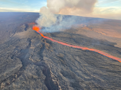
In late November, the Mauna Loa volcano in Hawaii erupted for the first time since 1984 and is […]
Read More
In late November, the Mauna Loa volcano in Hawaii erupted for the first time since 1984 and is […]

Operators of UK transport networks will be the first to benefit from Live Land, a satellite-based land monitoring system […]


Follow Us