No audio available for this content.
UAV technology developer Skyfish has introduced a computing platform for commercial drones that fully automates crucial infrastructure inspection and measurement tasks.
The Skyfish platform was unveiled and is being demonstrated at Booth #133 at the Commercial UAV Expo Americas conference being held Oct. 1-3 in Las Vegas.
Skyfish supports DJI and PixHawk flight controllers and other popular drone architectures, as well as 3D modeling software from companies such as Bentley Systems Inc.
Skyfish provides a smarter platform so anyone can fly, inspect and model complex infrastructure with an easy-to-use interface, the company said. The platform also pre-processes the collected infrastructure data and metadata to help create impeccable 3D models.
Available now to selected early-adopter customers, the Skyfish platform comprises:
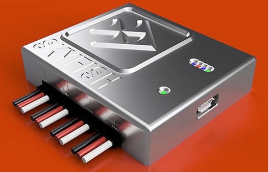
- SkyNode. Application-specific, onboard microcomputer controls the Skyfish system (and any Pixhawk 2.1 or DJI A3-based airframe.)
- SkyControl. Flight planning software that facilitates the creation and execution of complex flight plans in a few clicks.
- SkyFish Smart Gimbal. Delivers precision angle measurement with encoded motors to capture deep, highly accurate metadata for 2D mapping and 3D modeling.
- SkyFish M6 or a DJI Commercial Drone. An expandable and collapsible commercial-grade UAV.
“The Skyfish platform represents a sea change in commercial drone technology for infrastructure inspection, measurement and analysis,” said Mike Barkasi, project manager at Bentley Systems. “For our infrastructure customers that want to enable the benefits of drone sourced data — but need engineering grade accuracy for their 3D modeling — I believe leveraging both the Skyfish and Bentley platforms together is a good answer.”
“As a leader in the unmanned aerial system (UAS) industry since 2013, Vision Aerial’s been waiting for a well-designed, autonomous solution that provides both precision navigation and built-in sensor integration,” said Shane Beams, CEO at Vision Aerial. “Skyfish delivers exactly that.”


