No audio available for this content.
“Seen & Heard” is a monthly feature of GPS World magazine, traveling the world to capture interesting and unusual news stories involving the GNSS/PNT industry.
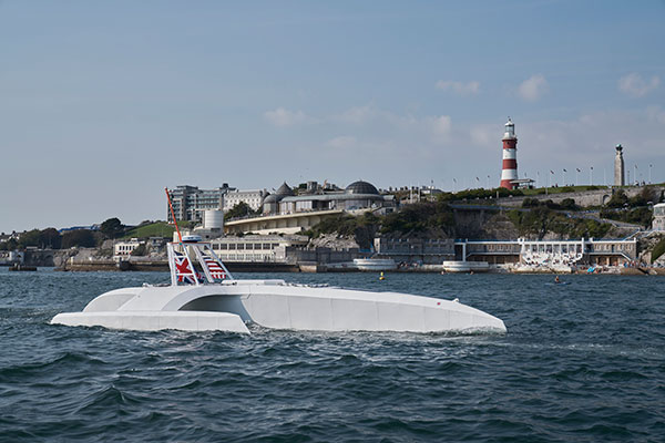
No pilgrims needed aboard
The autonomous Mayflower trimaran launched Sept. 16 from Plymouth, England, on a mission to traverse oceans and gather vital environmental data, guided by Veripos GNSS and inertial measurement units from iXBlue and Silicon Sensing. Ocean research non-profit ProMare joined with IBM on the Mayflower Autonomous Ship — an artificial intelligence and solar-powered marine research vessel, two years in the making. Designed to provide a safe, flexible and cost-effective way of gathering data about the ocean, the Mayflower works in tandem with scientists and other autonomous vessels to help understand critical issues such as global warming, micro-plastic pollution and marine mammal conservation.

A Guardian on the Bus
A school bus app aims to help monitor students’ exposure to others. App developer CalAmp’s Bus Guardian uses the same technology from its Here Comes the Bus app with an added layer of contact tracing. With Bus Guardian, parents can opt-in and invite their student to check on and off the bus. It uses telematics to convert a school bus into a contact tracing solution. Schools can deliver instant and actionable reports of ridership based on contact tracing — important if a student or driver becomes ill.

Rift splits Africa in two…eventually
GPS data is refining predictions of when Africa will split into two continents. In 5 to 10 million years , the Gulf of Aden and the Red Sea will flood the Afar region and the East African Rift Valley, creating a new ocean and continent. GPS data is precisely measuring ground movement as three tectonic plates peel away from each other at a triple junction, said Ken Macdonald, professor emeritus, University of California, Santa Barbara. “With GPS measurements, you can measure rates of movement down to a few millimeters per year,” Macdonald said. “As we get more and more measurements from GPS, we can get a much greater sense of what’s going on.”
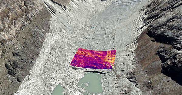
Dangerous Retreat
In a first for mapping glacier retreat in the Peruvian Andes, the CASCADA UK + Peru glacier project used a drone fitted with a FLIR Vue Pro R 640 thermal-imaging camera for insight. A thicker layer acts as insulation. Researcher Rosie Bisset, Edinburgh University, is building a mosaic of the images to better understand how surface cover is affecting the melt rate. The glaciers have shrunk by about 30% in the past few decades, and pose a serious threat to the water supply of in the Ancash region.


