No audio available for this content.
“Seen & Heard” is a monthly feature of GPS World magazine, traveling the world to capture interesting and unusual news stories involving the GNSS/PNT industry.

Sailing new school
An autonomous ship designed to recreate the Mayflower’s historic journey across the Atlantic 400 years ago returned to the UK after developing a mechanical problem. IBM’s Mayflower Autonomous Ship (MAS) set sail on June 15 on its 3,500-mile journey from Plymouth in the UK to Massachusetts in the United States. The voyage is expected to take about three weeks, and includes collections of data on marine life and sampling for plastic waste. The 50-foot long, solar-powered trimaran is capable of speeds of up to 10 knots (18 km/h) and is being navigated by on-board artificial intelligence (AI) with information from six cameras and 50 sensors. Project leaders say the AI worked perfectly. The ship navigates with precision GNSS, inertial measurement units, radar, weather station, SATCOM and the automatic identification system.

Sailing old school
U.S. Navy sailors aboard mine-countermeasures ship USS Patriot used celestial navigation to navigate an 1,100-mile voyage back to port on the western coast of Japan in July 2020. The voyage allowed the crew to improve their mariner skills as they used sextants to find their latitude and longitude and compasses to determine their heading. The exercise wasn’t entirely old school. The sailors entered the celestial measurements into a computer to pinpoint their position using the System to Estimate Latitude and Longitude Astronomically (STELLA). The combination of repeatedly inputting sextant measurements, the course and speed of the ship, and time into STELLA, provided an accurate fix of the ship’s position. For backup, Combat Information Center (CIC) watch standers followed the ship’s course with GPS. Training in celestial navigation returned to the Navy as a core competency in 2016, 17 years after the U.S. Naval Academy stopped requiring midshipmen to learn the technique.
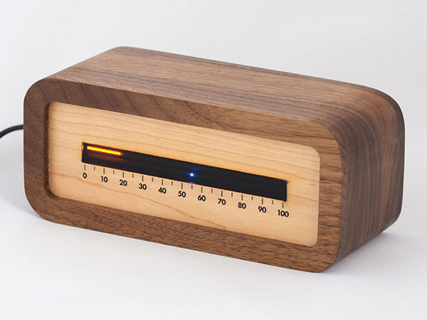
Linear clock shows sunrise, sunset
A creative technologist spent his COVID-19 downtime creating a device that uses a GNSS receiver to compute time relative to sunrise and sunset. “Since it derives time from the satellite signal, it never needs to be set, or ever adjusted for daylight saving time,” explains creator James Wilson on his webpage. The device uses satellite navigation and astronomy to show time as a progress bar measuring the percentage of the day elapsed since sunrise. A second indicator marks the time to sunset in blue.
Tracking Iran’s nuclear site
A team with Stanford University’s Center for International Security and Cooperation (CISAC) is keeping tabs on activity at Iran’s Natanz nuclear facility using BlackSky’s geospatial imagery and burst collection technology. BlackSky’s satellites provide intraday revisit capabilities, allowing CISAC’s research team to receive multiple images a day, throughout the day, rather than just one image collected at roughly the same time each day. The satellites also can capture a sequence of 20 images within minutes (burst collection) and splice them together to generate a moving sequence of activity. With BlackSky’s assistance, the research team was able to witness trucks emerging from the facility’s underground tunnels.


