Listen to this content
Maritime safety is underpinned by a precise understanding of a vessel’s location. Disrupted navigation systems and misleading positioning information can reduce situational awareness and increase the risks of groundings and collisions. Loss of navigational awareness is a particular threat in areas with small safety margins, such as constrained waterways and coastal regions.
For decades, the maritime industry has been reliant on Global Navigation Satellite Systems (GNSS) to provide this certainty. However, the technology depends on radio signals transmitted from satellites thousands of kilometers away. These signals are vulnerable to interference, including jamming and spoofing, while coverage limitations can also affect performance. As a result, overreliance on GNSS is becoming an increasing concern.
Interest is growing in alternative positioning systems that do not depend on external signals. Classical inertial navigation systems (INS) already provide such a capability through dead reckoning, which involves calculating position based on measured acceleration, rotation, and time from a known starting point. However, these systems are vulnerable to drift, where cumulative sensor errors cause accuracy to degrade over time and require periodic correction from external references.
Quantum navigation systems offer an upgrade, using quantum technologies, including quantum sensors and clocks, to measure time, acceleration and rotation with exceptional precision. These systems are less susceptible to drift and, in turn, less dependent on GNSS, providing a more resilient foundation for positioning in contested or signal-denied environments.
A growing problem
One of the most significant current threats to GNSS is the rise in spoofing and jamming. Jamming occurs when strong radio transmissions overwhelm satellite signals, preventing receivers from obtaining a reliable position. It may be targeted or incidental, with vessels affected by interference originating elsewhere. Spoofing presents a more insidious threat. By transmitting falsified signals, an attacker can manipulate a vessel’s perceived position, potentially concealing illicit activity or misdirecting navigation without immediate detection.
Recent geopolitical instability has made the scale of this issue harder to overlook. In the Strait of Hormuz, widespread GPS jamming and spoofing moved from occasional incidents to a persistent, region-wide hazard with reports of over a thousand vessels affected in a single 24-hour period. This forced operators to delay transits, restrict movement to daylight hours, or wait outside the Strait. The disruption illustrates the wider consequences that navigational uncertainty can create at one of the world’s most strategically important maritime chokepoints. The Strait of Hormuz is also not an isolated case; it highlights how dependent modern shipping has become on GNSS, and how vulnerable that dependence is when signals are disrupted.
Similar vulnerabilities can arise in other GNSS-challenged environments, including at high latitudes, where lower satellite elevation angles can result in poorer geometry and reduced positioning accuracy and integrity. This is becoming more operationally significant as Arctic routes such as the Northern Sea Route and Northwest Passage become increasingly navigable. Accurate positioning is key in Arctic navigation for ice avoidance, routing through narrow channels, and coordination with icebreakers. Outages or degraded GNSS integrity in these environments increase collision and grounding risks, especially where hydrographic data are sparse and real-time corrections are harder to maintain.
Against this backdrop, as the shipping industry moves towards autonomous and semi-autonomous cargo vessels, the need for navigation systems that can operate reliably without satellite input is also becoming more pressing. As levels of autonomy increase, navigation systems cannot necessarily rely on an onboard crew to identify GNSS degradation and fall back on visual or manual navigation methods.
Where classical systems fall short
Inertial navigation systems revolutionized marine navigation by allowing vessels to continuously estimate their position, speed, and direction without relying on external visual references or radio signals.
In 1958, the USS Nautilus made history by sailing under the North Pole using the N6A-1 inertial navigation system, demonstrating that a vessel could navigate accurately while submerged, relying only on inertial navigation. The fundamental principle remains the same. Accelerometers and gyroscopes measure a vessel’s acceleration and rotation, enabling its position to be estimated over time. These sensors sit within the ship and are not reliant on external signals to function.
Inertial navigation systems today function as a complement to GNSS, stepping in during outages rather than replacing satellite positioning altogether. However, they are prone to drift, with errors accumulating over time unless the navigation solution is periodically corrected using an external reference, such as GNSS, celestial observations, or other independent position fixes. This becomes an issue for vessels at sea for days or weeks in GNSS-denied or challenged environments.
The quantum alternative
Quantum inertial navigation improves on this system, increasing inertial measurement accuracy and further reducing reliance on GNSS.
Rather than a mechanical mass or electronic sensor, quantum inertial systems use a small cloud of atoms cooled to close to absolute zero. At this temperature, the atoms move slowly enough to be measured with extreme precision. A sequence of laser pulses places the atoms into a quantum superposition, allowing their matter waves to travel along two paths simultaneously. When the paths are later recombined, they produce an interference pattern that depends on any acceleration experienced during the measurement. By analyzing this pattern, the system can measure acceleration with extremely high precision.
Quantum sensors are less susceptible to drift and have greater long-term stability compared to their classical counterparts. As their measurements are based on stable atomic properties rather than mechanical or optical components that can age or vary with temperature, the slowly varying biases that cause position errors to accumulate over time are reduced. This could allow a vessel’s navigation solution to remain accurate for much longer without external recalibration or GNSS fixes.
Quantum navigation is broader than inertial sensing alone. Another important component is precision timing. Quantum clocks can provide an ultra-stable reference that is independent of GNSS signals.
Quantum clocks use the vibrations of atoms to measure time with extraordinary precision: the most advanced achieve accuracy to one part in a quintillion (1018), equivalent to losing no more than a second over tens of millions of years. Deployable navigation systems do not yet match this level of performance, but advances in quantum clock technology could provide highly accurate timing in environments where GNSS signals are unavailable or unreliable.
This precision matters for navigation because timing errors compound into position errors. A clock that holds its accuracy independently of GNSS gives a vessel a stable timing reference to work from. This supports both timing-dependent systems on board and, in combination with quantum inertial sensors, more accurate positioning over longer periods at sea.
Putting theory into practice
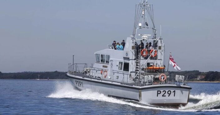
The UK has been leading the way in trialing quantum technology at sea. In June 2025, the Royal Navy put this technology to the test. Quantum sensing startup Aquark Technologies worked with the P2000 patrol vessel HMS Pursuer to trial AQlock, the UK’s first industrially designed and built cold atom clock. The system ran continuously on board in the Solent for three days, the first trial of its kind, marking a significant step forward for quantum navigation and reduced dependence on satellites.
Quantum sensors are still maturing from a lab-scale technology into something field-deployable: the cold atom systems that deliver the highest precision currently require vacuum chambers, laser systems and careful environmental control, which adds size, weight and cost. Nevertheless, recent advances such as AQlock demonstrate that cold atom technology can be miniaturised and ruggedised for deployment outside the laboratory.
The HARLEQUIN project (High Accuracy Robust deployable Quantum Inertial Navigation), led by CPI TMD in partnership with the University of Strathclyde, Covesion and Trinity House, has developed a hybrid system of this type. It combines conventional technologies, including a ring laser gyroscope and an atomic clock, with a cold-atom quantum accelerometer. The trial represented the first field demonstration of a cold-atom navigation system based on grating magneto-optical trap (gMOT) technology.
Looking ahead
Quantum inertial navigation is not yet ready to replace GNSS outright. The technology remains costly, the hardware is still being miniaturised for practical shipboard use, and further trials are needed to prove reliability across the range of conditions a vessel might encounter. These are real challenges, and progress will require sustained investment and testing.
However, as GNSS interference increases and interest in autonomous shipping grows, the maritime industry cannot afford to rely on a single source for something as fundamental as positioning. Greater resilience is likely to come from a system-of-systems approach that integrates multiple independent navigation techniques, including satellite, inertial, celestial and emerging quantum technologies. By combining complementary sources of information, vessels can maintain a reliable navigation solution even when one source becomes unavailable, degraded, or compromised.
Quantum navigation offers a promising path towards this resilience. By providing positioning, navigation, and timing capabilities that don’t depend on vulnerable satellite signals, it has the potential to reduce risk for vessels at sea and help safeguard the wider infrastructure that global shipping depends on.