No audio available for this content.
Asset and vegetation management applications help utilities minimize risk and improve the reliability of electric distribution networks
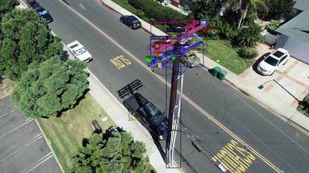
Geospatial data firm NV5 Geospatial is applying remote-sensing data analysis to improve the way utilities manage their distribution networks. The company mapped more than 5.5 million miles of utility distribution networks in the United States using a combination of lidar and orthoimagery sensors on mobile and airborne platforms to acquire data for both asset and vegetation management.
Analysis of this geospatial data enables electric utilities to minimize risk and maximize reliability, while increasing efficiency.
“An aging grid, workforce shortages, increasing energy demands and an uptick in major weather events are combining to create a perfect storm that could impact reliability, customer service and safety for electric utilities across the country,” said Eric Merten, vice president, Commercial Group at NV5 Geospatial. “A boots-on-the-ground approach to management cannot keep up with demands related to aging equipment, compliance, pole loading and vegetation encroaching on infrastructure.
“NV5 Geospatial’s innovative remote-sensing applications and data analysis tools give utilities the power to proactively address problems in their distribution network before they impact operations or customers,” Merten said.

Built on the success of its remote-sensing applications for utility transmission networks, NV5 Geospatial’s distribution management solutions offer end-to-end capabilities — from acquiring accurate, high-quality geospatial data to data analysis and visualization using custom viewers and enterprise geospatial information systems (GIS) — and can be customized to meet the use cases and budgets of utility companies.
Using NV5 Geospatial’s tools, distribution network asset managers can achieve compliance with National Electrical Safety Code (NESC) clearance guidelines, and get clear visibility into joint use of poles to prevent pirating.
The NV5 Geospatial remote-sensing data also can help quantify vegetation with distribution rights-of-way and determine risk based on proximity to wires and poles.


