No audio available for this content.
RTKsub, a Dutch provider of RTK corrections on the GEODNET network, has published the share of land within 25 km of a GEODNET reference station for 30 European countries, based on the network’s latest public coverage map. The study’s methodology is available here and briefly explained near the end of this post. The analysis covers all 27 European Union (EU) member states plus the United Kingdom, Switzerland, and Norway. For the whole EU the figure is 64.9 percent, ranging from 100 percent in Lithuania and 99.9 percent in Bulgaria, the Netherlands, Malta, and Slovenia to 27.3 percent in Sweden and 7.0 percent in Finland. The figures include the thin spots. The method is reproducible from GEODNET’s public map, and RTKsub says that it will repeat the calculation every quarter.
Nine of the 30 countries are above 95%. Besides the five at the top, these are mainland Portugal (98.7%), Germany (97.7%), Romania (96.9%) and Cyprus (95.7%). Central Europe is dense as well: Slovakia 90.9%, Hungary 89.4%, Austria 88.6% and Czechia 88.1%.
The large western countries have gaps. Italy stands at 64.1%, Spain at 60.8%, France at 56.8% and Ireland at 53.7%. Within countries the differences are larger still: Spanish regions range from 22.5% in La Rioja to 98.8% in the Balearic Islands, the United Kingdom combines 90.4% in England with 37.7% in Scotland, and Belgium (80.3%) splits into 100% for Flanders and Brussels and 64.1% for Wallonia.
The Nordic countries score low on land area. Sweden reaches 27.3%, Norway 17.1% and Finland 7.0%. The figures count land, not people or farmland: stations cluster where the users are. Oslo is at 100%, Stockholm County at 88.9%, Skåne at 79.4% and Uusimaa, the region around Helsinki, at 53.3%.
RTK (real-time kinematic) positioning brings a GNSS receiver to centimeter level by comparing it with a reference station at a known position. The error grows with the distance to that station. Receiver manufacturers specify RTK accuracy as a fixed error plus a distance-dependent part: u-blox, for example, rates its widely used ZED-F9P at 0.01 m + 1 ppm (one centimeter per 10 km), with the ppm term limited to baselines up to 20 km. For this analysis, 25 km is the reporting radius, chosen close to the baseline length for which receivers are specified. It is not a universal operating limit. Network RTK services that combine several stations are less sensitive to distance; GEODNET’s mountpoint delivers corrections from the nearest single station.
Share of land area within 25 km and within 100 km of a GEODNET reference station, calculated on the coverage map of November 10, 2026. The figures measure geographic proximity, not positioning accuracy, service uptime or the reliability of an individual station.
(Country: 25 km / 100 km)
1. Lithuania: 100% / 100%
2. Bulgaria: 99.9% / 100%
3. Netherlands: 99.9% / 100%
4. Malta: 99.9% / 100%
5. Slovenia: 99.9% / 100%
6. Portugal (mainland): 98.7% / 100%
7. Germany: 97.7% / 100%
8. Romania: 96.9% / 100%
9. Cyprus: 95.7% / 100%
10. Slovakia: 90.9% / 100%
11. Hungary: 89.4% / 100%
12. Austria: 88.6% / 100%
13. Czechia: 88.1% / 100%
14. Belgium: 80.3% / 100%
15. Switzerland: 80.2% / 100%
16. Luxembourg: 77.9% / 100%
17. Greece: 76.0% / 99.8%
18. Estonia: 75.6% / 100%
19. Poland: 73.8% / 100%
20. Latvia: 71.2% / 100%
21. United Kingdom: 69.7% / 99.4%
22. Croatia: 64.9% / 100%
23. Italy: 64.1% / 99.9%
24. Denmark: 62.1% / 100%
25. Spain (mainland and Balearic Islands): 60.8% / 100%
26. France (metropolitan): 56.8% / 100%
27. Ireland: 53.7% / 99.9%
28. Sweden: 27.3% / 81.1%
29. Norway (mainland): 17.1% / 85.6%
30. Finland: 7.0% / 38.4%
European Union (27): 64.9% / 92.9%
The 100 km radius is shown for context only; it says nothing about centimeter-level performance. At that radius, 27 of the 30 countries are above 99%; the exceptions are Norway, Sweden and Finland. Regional figures, more countries and the data: rtksub.com/coverage/by-country/.
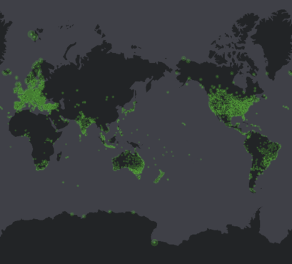
GEODNET is a network of GNSS reference stations hosted by companies and individuals. According to GEODNET, it counts more than 22,000 stations in more than 170 countries. According to GEODNET’s documentation, station rewards depend partly on signal quality, the number of satellites tracked, multipath and uptime, which gives hosts an incentive to place and maintain stations well. This analysis does not test the effect of those rules.
The figures are based on the 25 km and 100 km coverage polygons of the public GEODNET coverage map, retrieved on 10 November 2026 at 18:13 UTC, intersected with each country’s land area. Country and regional boundaries come from OpenStreetMap, land polygons from Natural Earth (1:10 million), so sea within territorial waters does not count. The overlap is calculated per line of latitude, 0.005 degrees apart, and weighted for latitude. Stations across a border count, because the coverage polygons do. The EU figure is the area-weighted total of the 27 member states.
Territories outside Europe are left out. France is metropolitan France including Corsica; Spain is the mainland and the Balearic Islands; Portugal and Norway are the mainland; Denmark excludes Greenland and the Faroe Islands; Cyprus is the whole island without the British base areas. Percentages are rounded to one decimal; 100% is shown only when coverage is complete.
The map is a snapshot. Stations go online and offline, and the figures move with them: between two retrievals on 10 November, Belgium went from 81.0% to 80.3%. Only public data was used, so anyone can repeat the calculation. RTKsub sells subscriptions to the network analysed here; this publication is its own calculation from GEODNET’s public map, not an independent performance audit.